بریسټول
ښکارېدونکې بڼه
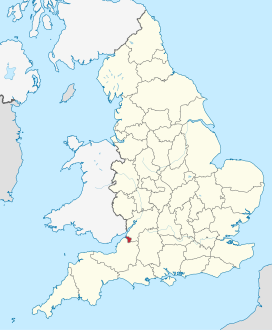
بریستول په انګلیسي bristol) د انګلستان له نیمه خپلواکه ښارونو څخه یو دی . بریسټول ښار د انګلستان هیواد په سویل لویدیځ کې د لندن ښار په ۱۶۹ کیلومترې کې موقیعت لري.
| بریستول | |
|---|---|
| City and County of Bristol[۱] | |
 د بریستول انځور
| |
| شعار: Virtute et Industria (By Virtue and Industry) |
|
د انګلستان په نقشه کې د بریسټول موقیعت
| |
| Lua error in Module:Mapframe at line 385: attempt to perform arithmetic on local 'lat_d' (a nil value). | |
| کورډېناټونه: ۵۱°۲۷′ شمال ۲°۳۵′ لویدیځ / 51.450°شمال 2.583°لويديځ | |
| Royal Charter | ۱۱۵۵ |
| County status | ۱۳۷۳ |
| اداري وېش | |
| هیواد | بریتانیا |
| هیواد | انګلستان |
| سیمه | سویل لویدیځ انګلستان |
| Status | ښار, and unitary authority |
| حکومت | |
| • ډول | Unitary authority |
| • Governing body | Bristol City Council |
| • Admin HQ | کينډۍ:ساده نوملړ |
| • Leadership | Mayor and Cabinet |
| • Mayor | Marvin Rees |
| • MPs | کينډۍ:ساده نوملړ |
| پراخوالی | |
| • City and county | [[۱ E+اصطلاحي تېروتنه: د ناپېژندلې ليکنښې لوښه "۱"._m²|۱۱۰ کلوميټر٢]] (۴۰ میله مربع) |
| لوړوالی | ۱۱ ميټره (۳۶ فوټ) [۲] |
| نفوس شمېرنه (۲۰۱۵) | |
| • City and county | ۴۴۲,۵۰۰ (Ranked ۱۰th district and [[List of ceremonial counties of England|کينډۍ:English cerem counties ceremonial county]]) |
| • د نفوسو کثافت | ۳۸۹۲/کلوميټر٢ (۱۰٬۰۸۰/ميله مربع) |
| • ښاري سیمه | ۶۱۷,۰۰۰ (۲٬۰۱۱ ONS estimate[۳]) |
| • ستره ښاري سيمه | ۱,۰۰۶,۶۰۰ (LUZ ۲۰۰۹) |
| • Ethnicity[۴] | کينډۍ:ساده نوملړ |
| وروستي مالومات | |
| وخت زون | ګینویچ ساعت (یوټیسی ۰۰:۰۰±) |
| • د اوړي وخت | د بریتانیا پسرلنی ساعت (ت.ع.م +۱) |
| Postcode | BS |
| سيمه ييز د زنګ کوډ | ۰۱۱۷, ۰۱۲۷۵ |
| آی اېس او 3166 | GB-BST |
| GVA | ۲۰۱۲ |
| • Total | اسټرلینګ پونډ 11.7bn ($19.4bn) (8th) |
| • Growth | کينډۍ:زیاتوالی ۱٫۶٪ |
| • Per capita | £۲۷٬۱۰۰ ($44,900) (5th) |
| • Growth | کينډۍ:زیاتوالی ۰٫۶٪ |
| رسمي وېبپاڼه | www.bristol.gov.uk |
| سمول |
|
تاریخ
[سمول]جغرافیه
[سمول]- ↑ "The Lord-Lieutenant of the County & City of Bristol". The Lord-Lieutenant of the County & City of Bristol. بياځلي په 8 June 2015.
- ↑ "Historical Weather for Bristol, England, United Kingdom". Weatherbase. Canty & Associates. بياځلي په 15 October 2015.
{{cite web}}: CS1 errors: archive-url (link) CS1 errors: unsupported parameter (link) - ↑ "The Population of Bristol August 2013" (PDF). Bristol City Council. خوندي شوی له the original (PDF) on 11 February 2014. بياځلي په 18 April 2015.
- ↑ "2011 Census: Ethnicgroup, local authorities in England and Wales". Census 2011. Office for National Statistics. بياځلي په 12 December 2012.

