
دوتنه:Map of Karelian dialects.png

د همدې ليدنې کچه: ۳۴۱ × ۶۰۰ پېکسل. نورې ژورليدنې: ۱۳۶ × ۲۴۰ پېکسل | ۴۲۶ × ۷۴۹ پېکسل.
اصلي دوتنه (۴۲۶ × ۷۴۹ پېکسل, د دوتنې کچه: ۶۲ کيلوبايټ, MIME بڼه: image/png)
لنډيز
| څرگندونه |
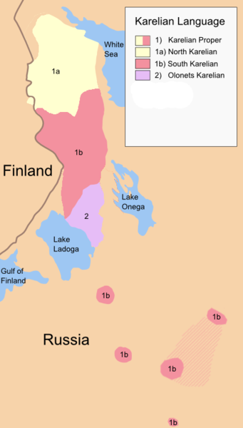
English: Map of Karelian dialects before the second World War. Map has present-day borders of Finland. |
| نېټه | |
| سرچينه | شخصي اثر, Data from http://www.kotus.fi/index.phtml?s=343 Anneli Hänninen 2006 |
| ليکوال | Maksamakkara |

|
This linguistic map image could be re-created using vector graphics as an SVG file. This has several advantages; see Commons:Media for cleanup for more information. If an SVG form of this image is available, please upload it and afterwards replace this template with
{{vector version available|new image name}}.
It is recommended to name the SVG file “Map of Karelian dialects.svg”—then the template Vector version available (or Vva) does not need the new image name parameter. |
منښتليک:
| I, the copyright holder of this work, release this work into the public domain. This applies worldwide. In some countries this may not be legally possible; if so: I grant anyone the right to use this work for any purpose, without any conditions, unless such conditions are required by law. |
د دوتنې پېښليک
په يوې نېټې/يوه وخت وټوکۍ چې د هماغه وخت او نېټې دوتنه چې څنگه ښکارېده هماغسې درښکاره شي.
| نېټه/وخت | بټنوک | ډډې | کارن | تبصره | |
|---|---|---|---|---|---|
| اوسنی | ۱۵:۵۹, ۲۲ نومبر ۲۰۱۹ | | ۴۲۶ × ۷۴۹ (۶۲ کيلوبايټ) | Paranaja | Updated based on newer version of the source https://www.kotus.fi/files/6912/karjalat_kartta_2019.png |
| ۱۹:۵۲, ۷ جون ۲۰۱۰ |  | ۴۲۶ × ۶۸۰ (۵۰ کيلوبايټ) | Maksamakkara | {{Information |Description={{en|1=Map of Karelian dialects before the second World War. Map has present-day borders of Finland.}} |Source={{own}}, Data from http://www.kotus.fi/files/523/uusi-karjala.jpg |Author=Maksamakkara |Date=20 |
د دوتنې کارېدنه
دا لاندينی مخ د همدې دوتنې سره تړنې لري:
د نړېوالې دوتنې کارېدنه
همدا دوتنه لاندينۍ نورې ويکي گانې کاروي:
- په af.wikipedia.org کارونې
- په ast.wikipedia.org کارونې
- په az.wikipedia.org کارونې
- په bg.wikipedia.org کارونې
- په ca.wikipedia.org کارونې
- په ca.wiktionary.org کارونې
- په cs.wikipedia.org کارونې
- په cy.wikipedia.org کارونې
- په da.wikipedia.org کارونې
- په de.wikipedia.org کارونې
- په el.wikipedia.org کارونې
- په es.wikipedia.org کارونې
- په fa.wikipedia.org کارونې
- په fi.wikipedia.org کارونې
- په fr.wikipedia.org کارونې
- په incubator.wikimedia.org کارونې
- په ja.wikipedia.org کارونې
- په myv.wikipedia.org کارونې
- په nn.wikipedia.org کارونې
- په no.wikipedia.org کارونې
- په olo.wikipedia.org کارونې
- په ru.wikinews.org کارونې
- په se.wikipedia.org کارونې
- په smn.wikipedia.org کارونې
- په sv.wikipedia.org کارونې
- په tt.wikipedia.org کارونې
- په vi.wikipedia.org کارونې
- په www.wikidata.org کارونې
- په zh.wikipedia.org کارونې