
دوتنه:Abu Reyhan Biruni-Earth Circumference.svg

اصلي دوتنه (SVG دوتنه، نومېنلي ۱٬۰۰۰ × ۹۰۰ پېکسل، د دوتنې کچه: ۱۶ کيلوبايټ)
لنډيز
| څرگندونه |
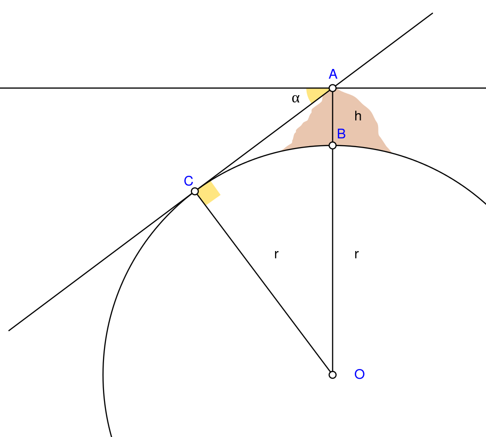
English: Biruni (973 - 1048) developed a new method using trigonometric calculations to compute earth's radius and circumference based on the angle between the horizontal line and true horizon from a mountain top with known height. He calculated the height of the mountain by going to two points at sea level with a known distance apart and then measuring the angle between the plain and the top of the mountain for both points.
Biruni's estimate of 6,339.9 km for the Earth radius had an error of 0.0026 and was 16.8 km less than the current value of 6,356.7 km. The idea came to him when he was on top of a tall mountain near Nandana in Pakistan. He measured the dip angle using an astrolabe and he applied to the law of sines formula. He also made use of algebra in his calculation.
Solution: Français : Biruni (973-1048) développa une nouvelle méthode utilisant la trigonométrie pour calculer le rayon et la ciconférence de la Terre, basée sur l'angle entre la ligne horizontale et l'horizon réel depuis le sommet d'une montagne de hauteur connue. Il calcula la hauteur de la montagne en se rendant en deux points situés au niveau de la mer dont l'écartement était connu, puis en mesurant l'angle entre la ligne horizontale formée par les deux points au niveau de la mer et le sommet de la montagne, et ceci depuis chacun des deux points.
L'estimation de Biruni de 6 339,9 km pour le rayon de la Terre comportait une erreur de 0,26 %, soit une valeur inférieure de 16,8 km par rapport à la valeur actuelle de 6 356,7 km. L'idée lui était venue alors qu'il se trouvait au sommet d'une haute montagne, près de Nandana en Inde. Il mesura l'angle d'incinaison avec un astrolabe et il appliqua la formule des sinus. Il fit également usage de l'algèbre pour ses calculs.
Solution : |
| نېټه | |
| سرچينه | شخصي اثر Using Geogebra and Inkscape |
| ليکوال | Nevit Dilmen |
| SVG genesis | and with GeoGebra. |
منښتليک:
- تاسې کولی شئ چې:
- بيا يې د نورو سره شريک کړئ – همدا اثر ولمېسئ، و وېشئ او بيا يې خپور کړئ
- بيا ادلون بدلون راولئ – بدل شوی اثر خپل کړئ
- د لاندې شرطونو له مخې:
- اړوندېدنه – تاسې بايد دا اثر د ليکوال يا منښتگر لخوا د ځانگړو شويو اصولو سره اړونده وگڼئ (خو په دې توگه نه چې داسې ښکاره شي چې گنې تاسې يا ستاسې لخوا کارېدنه د اثر د ملاتړ سبب شوی)
- يوشان شريکول – که تاسې همدا اثر بدلوئ، رغوئ، او يا يې هم سر له نوي جوړوئ نو په پايله کې رامېنځ ته شوی اثر به يوازې د همدې دوتنې ورته منښتليک پر بنسټ خپروئ.
د دوتنې پېښليک
په يوې نېټې/يوه وخت وټوکۍ چې د هماغه وخت او نېټې دوتنه چې څنگه ښکارېده هماغسې درښکاره شي.
| نېټه/وخت | بټنوک | ډډې | کارن | تبصره | |
|---|---|---|---|---|---|
| اوسنی | ۰۵:۲۵, ۲ مې ۲۰۱۰ | | ۱٬۰۰۰ × ۹۰۰ (۱۶ کيلوبايټ) | Nevit | Crop |
| ۰۵:۲۱, ۲ مې ۲۰۱۰ |  | ۱٬۳۹۰ × ۱٬۲۲۰ (۱۶ کيلوبايټ) | Nevit | Yellow removed | |
| ۰۵:۱۹, ۲ مې ۲۰۱۰ |  | ۱٬۳۹۰ × ۱٬۲۲۰ (۱۶ کيلوبايټ) | Nevit | Image version | |
| ۰۵:۱۸, ۲ مې ۲۰۱۰ |  | ۶۴۰ × ۴۸۰ (۲۲ کيلوبايټ) | Nevit | {{Information |Description={{en|1=Biruni (973 - 1048) developed a new method using trigonometric calculations to compute earth's circumference based on the angle between the horizontal line and true horizon from a mountain top with known height. He calcu |
د دوتنې کارېدنه
دا لاندينی مخ د همدې دوتنې سره تړنې لري:
د نړېوالې دوتنې کارېدنه
همدا دوتنه لاندينۍ نورې ويکي گانې کاروي:
- په af.wikipedia.org کارونې
- په ar.wikipedia.org کارونې
- په bcl.wikipedia.org کارونې
- په bn.wikipedia.org کارونې
- په bs.wikipedia.org کارونې
- په diq.wikipedia.org کارونې
- په en.wikipedia.org کارونې
- په es.wikipedia.org کارونې
- په fa.wikipedia.org کارونې
- په fr.wikipedia.org کارونې
- په he.wikipedia.org کارونې
- په hr.wikipedia.org کارونې
- په id.wikipedia.org کارونې
- په it.wikipedia.org کارونې
- په ja.wikipedia.org کارونې
- په pt.wikipedia.org کارونې
- په pt.wikibooks.org کارونې
- په ro.wikipedia.org کارونې
- په ru.wikipedia.org کارونې
- په sd.wikipedia.org کارونې
- په sh.wikipedia.org کارونې
- په sr.wikipedia.org کارونې
- په ta.wikipedia.org کارونې
- په tr.wikipedia.org کارونې
- په tt.wikipedia.org کارونې
- په uk.wikipedia.org کارونې
- په uz.wikipedia.org کارونې
- په www.wikidata.org کارونې
د دې دوتنې نورې نړېوالې کارېدنې کتل.