
دوتنه:Location of Donetsk People's Republic.png

د همدې ليدنې کچه: ۸۰۰ × ۵۸۶ پېکسل. نورې ژورليدنې: ۳۲۰ × ۲۳۴ پېکسل | ۶۴۰ × ۴۶۹ پېکسل | ۱٬۰۲۴ × ۷۵۰ پېکسل | ۱٬۲۸۰ × ۹۳۸ پېکسل | ۱٬۶۹۴ × ۱٬۲۴۱ پېکسل.
اصلي دوتنه (۱٬۶۹۴ × ۱٬۲۴۱ پېکسل, د دوتنې کچه: ۹۰۱ کيلوبايټ, MIME بڼه: image/png)

|
This locator map image could be re-created using vector graphics as an SVG file. This has several advantages; see Commons:Media for cleanup for more information. If an SVG form of this image is available, please upload it and afterwards replace this template with
{{vector version available|new image name}}.
It is recommended to name the SVG file “Location of Donetsk People's Republic.svg”—then the template Vector version available (or Vva) does not need the new image name parameter. |
لنډيز
| څرگندونه |
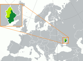
English: territory controlled by the self-proclaimed Donetsk People's Republic (dark green) inside of the Donetsk Oblast (green, light and dark) Русский: Заявленная (светло-зелёный) территория Донецкой Народной Республики, совпадающая с территорией Донецкой области Украины, и контролируемая ДНР территория (тёмно-зелёный) Français : Territoire de la République populaire de Donetsk (vert foncé) dans l'oblast de Donetsk (vert clair) |
| نېټه | |
| سرچينه |
شخصي اثر |
| ليکوال | Oude-rusman |
| نورې بڼې | Derivative works of this file: Location of Donetsk People's Republic (before 2022 invasion).png |
.png)
منښتليک:
| This map is ineligible for copyright and therefore in the public domain, because it consists entirely of information that is common property and contains no original authorship. For more information, see Commons:Threshold of originality § Maps.
|
د دوتنې پېښليک
په يوې نېټې/يوه وخت وټوکۍ چې د هماغه وخت او نېټې دوتنه چې څنگه ښکارېده هماغسې درښکاره شي.
| نېټه/وخت | بټنوک | ډډې | کارن | تبصره | |
|---|---|---|---|---|---|
| اوسنی | ۰۳:۳۱, ۲۳ فبروري ۲۰۲۳ | | ۱٬۶۹۴ × ۱٬۲۴۱ (۹۰۱ کيلوبايټ) | DinoSoupCanada | Update |
| ۱۹:۲۷, ۱۳ نومبر ۲۰۲۲ |  | ۱٬۶۹۴ × ۱٬۲۴۱ (۷۱۳ کيلوبايټ) | DinoSoupCanada | Since the article is repurposed as a disputed subject of Russia, then it's fine to edit again. | |
| ۲۲:۳۸, ۱۲ اکتوبر ۲۰۲۲ |  | ۱٬۶۹۴ × ۱٬۲۴۱ (۲۶۵ کيلوبايټ) | DinoSoupCanada | DPR doesn't exist after September 30th | |
| ۱۹:۲۷, ۱ اکتوبر ۲۰۲۲ |  | ۱٬۶۹۴ × ۱٬۲۴۱ (۲۶۵ کيلوبايټ) | Nahabino | Update per ISW; last update for self-proclaimed DPR state | |
| ۲۳:۳۴, ۳۰ سپټمبر ۲۰۲۲ |  | ۱٬۶۹۴ × ۱٬۲۴۱ (۲۶۵ کيلوبايټ) | Nahabino | Update per ISW | |
| ۲۲:۵۳, ۲۸ سپټمبر ۲۰۲۲ |  | ۱٬۶۹۴ × ۱٬۲۴۱ (۲۶۶ کيلوبايټ) | Nahabino | Update per ISW | |
| ۲۳:۰۵, ۲۷ سپټمبر ۲۰۲۲ |  | ۱٬۶۹۴ × ۱٬۲۴۱ (۲۶۶ کيلوبايټ) | Nahabino | Update per ISW | |
| ۲۳:۳۴, ۲۶ سپټمبر ۲۰۲۲ |  | ۱٬۶۹۴ × ۱٬۲۴۱ (۲۶۶ کيلوبايټ) | Nahabino | Update per ISW | |
| ۰۹:۲۱, ۲۶ سپټمبر ۲۰۲۲ |  | ۱٬۶۹۴ × ۱٬۲۴۱ (۷۱۴ کيلوبايټ) | Durranistan | update per File:Russian Occupation of Donetsk Oblast.svg | |
| ۰۸:۴۲, ۲۴ سپټمبر ۲۰۲۲ |  | ۱٬۶۹۴ × ۱٬۲۴۱ (۲۶۶ کيلوبايټ) | Nahabino | Update per ISW |
د دوتنې کارېدنه
دا لاندينی مخ د همدې دوتنې سره تړنې لري:
د نړېوالې دوتنې کارېدنه
همدا دوتنه لاندينۍ نورې ويکي گانې کاروي:
- په af.wikipedia.org کارونې
- په azb.wikipedia.org کارونې
- په be-tarask.wikipedia.org کارونې
- په be.wikipedia.org کارونې
- په bg.wikipedia.org کارونې
- په br.wikipedia.org کارونې
- په ckb.wikipedia.org کارونې
- په crh.wikipedia.org کارونې
- په cs.wikipedia.org کارونې
- په cv.wikipedia.org کارونې
- په en.wikipedia.org کارونې
- په es.wikipedia.org کارونې
- په ext.wikipedia.org کارونې
- په fa.wikipedia.org کارونې
- په fi.wikipedia.org کارونې
- په fr.wikipedia.org کارونې
- په he.wikipedia.org کارونې
- په hu.wikipedia.org کارونې
- په id.wikipedia.org کارونې
- په ie.wikipedia.org کارونې
- په is.wikipedia.org کارونې
- په it.wikipedia.org کارونې
- په ja.wikipedia.org کارونې
- په ka.wikipedia.org کارونې
- په ko.wikipedia.org کارونې
- په ku.wikipedia.org کارونې
- په kv.wikipedia.org کارونې
- په lij.wikipedia.org کارونې
- په li.wikipedia.org کارونې
- په lt.wikipedia.org کارونې
- په lv.wikipedia.org کارونې
- په mi.wikipedia.org کارونې
- په ml.wikipedia.org کارونې
- په nl.wikipedia.org کارونې
- په no.wikipedia.org کارونې
- په pl.wikipedia.org کارونې
- په pnb.wikipedia.org کارونې
- په pt.wikipedia.org کارونې
- په sah.wikipedia.org کارونې
- په scn.wikipedia.org کارونې
- په sco.wikipedia.org کارونې
- په simple.wikipedia.org کارونې
- په sl.wikipedia.org کارونې
- په sq.wikipedia.org کارونې
- په sr.wikipedia.org کارونې
د دې دوتنې نورې نړېوالې کارېدنې کتل.