
دوتنه:Chad sat.jpg

د همدې ليدنې کچه: ۳۹۴ × ۵۹۹ پېکسل. نورې ژورليدنې: ۱۵۸ × ۲۴۰ پېکسل | ۳۱۶ × ۴۸۰ پېکسل | ۵۰۵ × ۷۶۸ پېکسل | ۱٬۲۶۵ × ۱٬۹۲۲ پېکسل.
اصلي دوتنه (۱٬۲۶۵ × ۱٬۹۲۲ پېکسل, د دوتنې کچه: ۱٫۷۹ مېگابايټ, MIME بڼه: image/jpeg)
لنډيز
| څرگندونه |
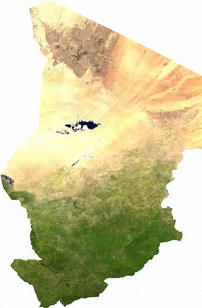
Español: Mapa satelital de Chad, se puede apreciar el contraste entre la zona árida del norte, que corresponde al sur del Sahara; y la zona fértil del sur.
Los musulmanes del norte piden privilegios económicos.
|
| نېټه | |
| سرچينه | user |
| ليکوال | Cwolfsheep |
منښتليک:
| This file is in the public domain, because it was generated by a user, using free sources available at The Map Library.
Note that this does not include the maps in the Global Administrative Areas section of the homepage. |
د دوتنې پېښليک
په يوې نېټې/يوه وخت وټوکۍ چې د هماغه وخت او نېټې دوتنه چې څنگه ښکارېده هماغسې درښکاره شي.
| نېټه/وخت | بټنوک | ډډې | کارن | تبصره | |
|---|---|---|---|---|---|
| اوسنی | ۰۳:۴۳, ۱۳ جولای ۲۰۰۶ | | ۱٬۲۶۵ × ۱٬۹۲۲ (۱٫۷۹ مېگابايټ) | Unquietwiki | ECW to TIFF to JPEG (100% quality; progressive formatting). {{PD-MapLibrary}} |
د دوتنې کارېدنه
دا لاندينی مخ د همدې دوتنې سره تړنې لري:
د نړېوالې دوتنې کارېدنه
همدا دوتنه لاندينۍ نورې ويکي گانې کاروي:
- په af.wikipedia.org کارونې
- په als.wikipedia.org کارونې
- په ar.wikipedia.org کارونې
- په bg.wikipedia.org کارونې
- په bs.wikipedia.org کارونې
- په ca.wikipedia.org کارونې
- په da.wikipedia.org کارونې
- Tchad
- Tchads historie
- Wikipedia:Dagens skandinaviske artikel/september 2009
- Wikipedia:Dagens skandinaviske artikel/Svensk/Uge 36, 2009
- Wikipedia:Dagens skandinaviske artikel/august 2012
- Wikipedia:Dagens skandinaviske artikel/Bokmål/Uge 32, 2012
- Wikipedia:Dagens skandinaviske artikel/maj 2014
- Wikipedia:Dagens skandinaviske artikel/Søndag/Uge 20, 2014
- په de.wikipedia.org کارونې
- په de.wikiversity.org کارونې
- په el.wikipedia.org کارونې
- په en.wikipedia.org کارونې
- په eo.wikipedia.org کارونې
- په es.wikipedia.org کارونې
- په eu.wikipedia.org کارونې
- په fa.wikipedia.org کارونې
- په fr.wikipedia.org کارونې
- په hu.wikipedia.org کارونې
- په ig.wikipedia.org کارونې
- په is.wikipedia.org کارونې
- په it.wikipedia.org کارونې
- په ja.wikipedia.org کارونې
- په ka.wikipedia.org کارونې
- په kk.wikipedia.org کارونې
- په li.wikipedia.org کارونې
- په mn.wikipedia.org کارونې
- په mt.wikipedia.org کارونې
- په nn.wikipedia.org کارونې
- په no.wikipedia.org کارونې
د دې دوتنې نورې نړېوالې کارېدنې کتل.