
دوتنه:Pacific-Ocean-Pitcairn-Island-on-globe-view-English.jpg
Pacific-Ocean-Pitcairn-Island-on-globe-view-English.jpg (۴۰۰ × ۴۰۰ پېکسل, د دوتنې کچه: ۵۹ کيلوبايټ, MIME بڼه: image/jpeg)

|
This locator map image could be re-created using vector graphics as an SVG file. This has several advantages; see Commons:Media for cleanup for more information. If an SVG form of this image is available, please upload it and afterwards replace this template with
{{vector version available|new image name}}.
It is recommended to name the SVG file “Pacific-Ocean-Pitcairn-Island-on-globe-view-English.svg”—then the template Vector version available (or Vva) does not need the new image name parameter. |


لنډيز
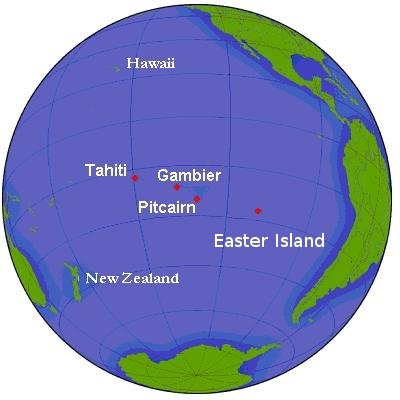
Simple map of globe, seen from area of Pitcairn Island and Tahiti. Ocean waters along continental shelves are shaded in darker hue. Parallels of latitude are at 15° intervals. Labels are in English.
Source URL (Wikimedia Commons): http://upload.wikimedia.org/wikipedia/commons/2/2c/Pitcairn.png (file downloaded, cropped, and re-labeled in larger font, as JPEG format, 10x times faster than PNG format).
This file, in JPEG-format, is intended for use in frequently-read articles (might display 20x times faster than larger PNG-format file, and with large, clear labels).
منښتليک:

|
د دې لاسوند د لمېسلو، وېشلو او/يا هم د بدلولو پرېښه د GNU د وړيا لاسوندکښنې منښتليک 1.2 بڼې او يا هم تر دې نوې بڼې چې د وړيا ساوتريو بنسټ لخوا خپره شوې وي ورکړل شوې، د نابدلېدونکو برخو او د مخ-پوښ او د شا-پوښ د متنونو پرته. د دې منښتليک يوه لمېسه د GNU د وړيا لاسوندکښنې منښتليک په سرليک برخه کې شامل شوی. |
| دا دوتنه د کريټيف کامنز Attribution-Share Alike 3.0 Unported په منښتليک سمبال ده. | ||
| ||
| This licensing tag was added to this file as part of the GFDL licensing update. |
- تاسې کولی شئ چې:
- بيا يې د نورو سره شريک کړئ – همدا اثر ولمېسئ، و وېشئ او بيا يې خپور کړئ
- بيا ادلون بدلون راولئ – بدل شوی اثر خپل کړئ
- د لاندې شرطونو له مخې:
- اړوندېدنه – تاسې بايد دا اثر د ليکوال يا منښتگر لخوا د ځانگړو شويو اصولو سره اړونده وگڼئ (خو په دې توگه نه چې داسې ښکاره شي چې گنې تاسې يا ستاسې لخوا کارېدنه د اثر د ملاتړ سبب شوی)
- يوشان شريکول – که تاسې همدا اثر بدلوئ، رغوئ، او يا يې هم سر له نوي جوړوئ نو په پايله کې رامېنځ ته شوی اثر به يوازې د همدې دوتنې ورته منښتليک پر بنسټ خپروئ.
د دوتنې پېښليک
په يوې نېټې/يوه وخت وټوکۍ چې د هماغه وخت او نېټې دوتنه چې څنگه ښکارېده هماغسې درښکاره شي.
| نېټه/وخت | بټنوک | ډډې | کارن | تبصره | |
|---|---|---|---|---|---|
| اوسنی | ۱۵:۴۱, ۲۱ جنوري ۲۰۱۴ | | ۴۰۰ × ۴۰۰ (۵۹ کيلوبايټ) | AxG | Gambieri > Gambier |
| ۱۶:۴۷, ۲۲ مارچ ۲۰۰۹ |  | ۴۰۰ × ۴۰۰ (۲۳ کيلوبايټ) | AnonyLog | added Easter Island label | |
| ۱۹:۲۲, ۱۹ جنوري ۲۰۰۷ |  | ۴۰۰ × ۴۰۰ (۲۰ کيلوبايټ) | Wikid77 | Simple map of globe, seen from area of Pitcairn Island and Tahiti. Ocean waters along continental shelves are shaded in darker hue. Parallels of latitude are at 20-degree intervals. Labels are in Engl |
د دوتنې کارېدنه
دا لاندينی مخ د همدې دوتنې سره تړنې لري:
د نړېوالې دوتنې کارېدنه
همدا دوتنه لاندينۍ نورې ويکي گانې کاروي:
- په af.wikipedia.org کارونې
- په ca.wikipedia.org کارونې
- په cs.wikipedia.org کارونې
- په en.wikipedia.org کارونې
- په fa.wikipedia.org کارونې
- په fiu-vro.wikipedia.org کارونې
- په io.wikipedia.org کارونې
- په is.wikipedia.org کارونې
- په lt.wiktionary.org کارونې
- په pt.wikipedia.org کارونې
- په ta.wikipedia.org کارونې
- په ur.wikipedia.org کارونې
- په vi.wikipedia.org کارونې