
دوتنه:Malta topographic map.png
تر دې کچې لوړې بېلن نښې نشته.
Malta_topographic_map.png (۷۶۵ × ۴۹۹ پېکسل, د دوتنې کچه: ۹۳ کيلوبايټ, MIME بڼه: image/png)
لنډيز
| څرگندونه |
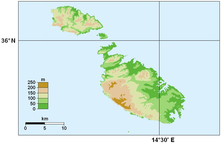
English: Topographic map of Malta. |
||
| نېټه | |||
| سرچينه | |||
| ليکوال |
Original by Hamelin de Guettelet. Retouched by Piroska. |
||
| اجازه (دا دوتنه بيا کارول) |
Hamelin de Guettelet, the copyright holder of this work, hereby publishes it under the following license:
|

د دوتنې پېښليک
په يوې نېټې/يوه وخت وټوکۍ چې د هماغه وخت او نېټې دوتنه چې څنگه ښکارېده هماغسې درښکاره شي.
| نېټه/وخت | بټنوک | ډډې | کارن | تبصره | |
|---|---|---|---|---|---|
| اوسنی | ۰۱:۴۸, ۱۰ نومبر ۲۰۰۸ | | ۷۶۵ × ۴۹۹ (۹۳ کيلوبايټ) | Piroska | {{Information |Description={{en|1=Topographic map of Malta. Cutting out from Europe location Malte.png.}} |Source=Own work by uploader |Author=Piroska |Date=10th November 2008 |Permission={{self|FAL}} |
د دوتنې کارېدنه
دا لاندينی مخ د همدې دوتنې سره تړنې لري:
د نړېوالې دوتنې کارېدنه
همدا دوتنه لاندينۍ نورې ويکي گانې کاروي:
- په de.wikibooks.org کارونې
- په en.wikipedia.org کارونې
- په fa.wikipedia.org کارونې
- په fi.wikipedia.org کارونې
- په fr.wikipedia.org کارونې
- په hu.wikipedia.org کارونې
- په incubator.wikimedia.org کارونې
- په vep.wikipedia.org کارونې