
دوتنه:LanguageMap-Lingala-Larger Location.png
تر دې کچې لوړې بېلن نښې نشته.
LanguageMap-Lingala-Larger_Location.png (۳۸۸ × ۳۴۱ پېکسل, د دوتنې کچه: ۱۳ کيلوبايټ, MIME بڼه: image/png)

|
This linguistic map image could be re-created using vector graphics as an SVG file. This has several advantages; see Commons:Media for cleanup for more information. If an SVG form of this image is available, please upload it and afterwards replace this template with
{{vector version available|new image name}}.
It is recommended to name the SVG file “LanguageMap-Lingala-Larger Location.svg”—then the template Vector version available (or Vva) does not need the new image name parameter. |
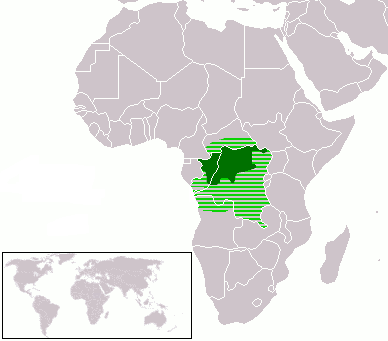
- Dark Green: Lingala native speakers
- Light Green: Area where Lingala is sometimes used
| I, the copyright holder of this work, release this work into the public domain. This applies worldwide. In some countries this may not be legally possible; if so: I grant anyone the right to use this work for any purpose, without any conditions, unless such conditions are required by law. |
د دوتنې پېښليک
په يوې نېټې/يوه وخت وټوکۍ چې د هماغه وخت او نېټې دوتنه چې څنگه ښکارېده هماغسې درښکاره شي.
| نېټه/وخت | بټنوک | ډډې | کارن | تبصره | |
|---|---|---|---|---|---|
| اوسنی | ۱۹:۳۸, ۸ مارچ ۲۰۱۸ | | ۳۸۸ × ۳۴۱ (۱۳ کيلوبايټ) | Maphobbyist | Check |
| ۱۹:۳۳, ۸ مارچ ۲۰۱۸ |  | ۳۸۸ × ۳۴۱ (۱۳ کيلوبايټ) | Maphobbyist | South Sudan border | |
| ۰۶:۱۸, ۱۳ اپرېل ۲۰۱۲ |  | ۳۸۸ × ۳۴۱ (۱۶ کيلوبايټ) | Hoshie | added South Sudan and Cabinda (Angola). Under same Lic. | |
| ۰۳:۱۹, ۱۲ اپرېل ۲۰۰۵ |  | ۳۸۸ × ۳۴۱ (۶ کيلوبايټ) | Moyogo | better colours | |
| ۰۳:۱۳, ۱۲ اپرېل ۲۰۰۵ |  | ۳۸۸ × ۳۴۱ (۶ کيلوبايټ) | Moyogo | Lingala Language * Dark Green: Lingala native speakers * Light Green: Area where Lingala is sometimes used {{PD}} Category:Linguistic maps |
د دوتنې کارېدنه
دا لاندينی مخ د همدې دوتنې سره تړنې لري:
د نړېوالې دوتنې کارېدنه
همدا دوتنه لاندينۍ نورې ويکي گانې کاروي:
- په af.wikipedia.org کارونې
- په als.wikipedia.org کارونې
- په am.wikipedia.org کارونې
- په ar.wikipedia.org کارونې
- په ast.wikipedia.org کارونې
- په bn.wikipedia.org کارونې
- په br.wikipedia.org کارونې
- په ca.wikipedia.org کارونې
- په ckb.wikipedia.org کارونې
- په cy.wikipedia.org کارونې
- په de.wikipedia.org کارونې
- په el.wiktionary.org کارونې
- په en.wikipedia.org کارونې
- په eo.wikipedia.org کارونې
- په es.wikipedia.org کارونې
- په et.wikipedia.org کارونې
- په eu.wikipedia.org کارونې
- په fr.wikipedia.org کارونې
- په fr.wikivoyage.org کارونې
- په gl.wikipedia.org کارونې
- په id.wikipedia.org کارونې
- په ig.wikipedia.org کارونې
- په ja.wikipedia.org کارونې
- په kbd.wikipedia.org کارونې
- په kg.wikipedia.org کارونې
- په ko.wikipedia.org کارونې
- په kv.wikipedia.org کارونې
- په ln.wikipedia.org کارونې
- په lv.wikipedia.org کارونې
- په nl.wikipedia.org کارونې
- په nn.wikipedia.org کارونې
- په no.wikipedia.org کارونې
- په oc.wikipedia.org کارونې
- په pl.wikipedia.org کارونې
- په pt.wikipedia.org کارونې
- په qu.wikipedia.org کارونې
- په ru.wikipedia.org کارونې
- په rw.wikipedia.org کارونې
- په sat.wikipedia.org کارونې
- په sk.wikipedia.org کارونې
- په sr.wikipedia.org کارونې
- په sv.wikipedia.org کارونې
- په ta.wikipedia.org کارونې
د دې دوتنې نورې نړېوالې کارېدنې کتل.