
دوتنه:Gorno badakhshan map.png

د همدې ليدنې کچه: ۸۰۰ × ۵۹۸ پېکسل. نورې ژورليدنې: ۳۲۰ × ۲۳۹ پېکسل | ۶۴۰ × ۴۷۹ پېکسل | ۹۴۸ × ۷۰۹ پېکسل.
اصلي دوتنه (۹۴۸ × ۷۰۹ پېکسل, د دوتنې کچه: ۲۰ کيلوبايټ, MIME بڼه: image/png)

|
This file requires updating because: The China-Tajikistan border has changed. In doing so, you could add a timestamp to the file.
|
لنډيز
| څرگندونه |
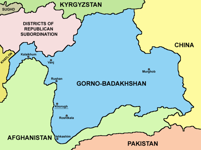
English: Map of Gorno-Badakhshan. |
| نېټه | |
| سرچينه | شخصي اثر |
| ليکوال | PANONIAN |
منښتليک:
زه، د دې اثر د خپرولو او لمېسلو خاوند، دا دوتنه د لاندې منښتليک پر بنسټ دلته خپروم:
| This file is made available under the Creative Commons CC0 1.0 Universal Public Domain Dedication. | |
| The person who associated a work with this deed has dedicated the work to the public domain by waiving all of their rights to the work worldwide under copyright law, including all related and neighboring rights, to the extent allowed by law. You can copy, modify, distribute and perform the work, even for commercial purposes, all without asking permission.
|
د دوتنې پېښليک
په يوې نېټې/يوه وخت وټوکۍ چې د هماغه وخت او نېټې دوتنه چې څنگه ښکارېده هماغسې درښکاره شي.
| نېټه/وخت | بټنوک | ډډې | کارن | تبصره | |
|---|---|---|---|---|---|
| اوسنی | ۲۱:۱۵, ۹ اگسټ ۲۰۲۳ | | ۹۴۸ × ۷۰۹ (۲۰ کيلوبايټ) | Lojwe | Cropped 2 % horizontally, 5 % vertically using CropTool with precise mode. |
| ۰۴:۰۸, ۲۷ سپټمبر ۲۰۲۱ |  | ۹۷۰ × ۷۴۹ (۵۷ کيلوبايټ) | GPinkerton | Reverted to version as of 09:58, 14 May 2013 (UTC) COM:CROP | |
| ۱۷:۲۵, ۴ اپرېل ۲۰۲۱ |  | ۹۷۰ × ۷۴۹ (۴۷ کيلوبايټ) | Claude Zygiel | Differenciate international boundaries (black) from administrative of Tadjikistan (grey) | |
| ۰۹:۵۸, ۱۴ مې ۲۰۱۳ |  | ۹۷۰ × ۷۴۹ (۵۷ کيلوبايټ) | PANONIAN | {{Information |Description ={{en|1=Map of Gorno-Badakhshan.}} |Source ={{own}} |Author =PANONIAN |Date =2013 |Permission = |other_versions = }} |
د دوتنې کارېدنه
دا لاندينی مخ د همدې دوتنې سره تړنې لري:
د نړېوالې دوتنې کارېدنه
همدا دوتنه لاندينۍ نورې ويکي گانې کاروي:
- په be.wikipedia.org کارونې
- په bg.wikipedia.org کارونې
- په cs.wikipedia.org کارونې
- په el.wikipedia.org کارونې
- په en.wikipedia.org کارونې
- په eo.wikipedia.org کارونې
- په es.wikipedia.org کارونې
- په et.wikipedia.org کارونې
- په fa.wikipedia.org کارونې
- په fi.wikipedia.org کارونې
- په fr.wikipedia.org کارونې
- په gl.wikipedia.org کارونې
- په hi.wikipedia.org کارونې
- په id.wikipedia.org کارونې
- په incubator.wikimedia.org کارونې
- په it.wikipedia.org کارونې
- په kaa.wikipedia.org کارونې
- په ko.wikipedia.org کارونې
- په lt.wikipedia.org کارونې
- په pl.wikipedia.org کارونې
- په pnb.wikipedia.org کارونې
- په pt.wikipedia.org کارونې
- په sr.wikipedia.org کارونې
- په sv.wikipedia.org کارونې
- په ta.wikipedia.org کارونې
- په tg.wikipedia.org کارونې
- په tr.wikipedia.org کارونې
- په ur.wikipedia.org کارونې
- په uz.wikipedia.org کارونې
- په vi.wikipedia.org کارونې
- په xmf.wikipedia.org کارونې
- په zh.wikipedia.org کارونې