
دوتنه:SH-60B helicopter flies over Sendai.jpg

د همدې ليدنې کچه: ۸۰۰ × ۵۳۴ پېکسل. نورې ژورليدنې: ۳۲۰ × ۲۱۴ پېکسل | ۶۴۰ × ۴۲۷ پېکسل | ۱٬۰۲۴ × ۶۸۴ پېکسل | ۱٬۲۸۰ × ۸۵۵ پېکسل | ۲٬۷۶۳ × ۱٬۸۴۵ پېکسل.
اصلي دوتنه (۲٬۷۶۳ × ۱٬۸۴۵ پېکسل, د دوتنې کچه: ۳٫۷۸ مېگابايټ, MIME بڼه: image/jpeg)
لنډيز
| څرگندونه |
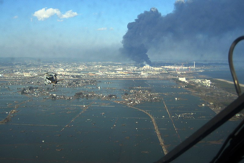
English: An SH-60F helicopter assigned to the Chargers of Helicopter Antisubmarine Squadron (HS) 14 from Naval Air Facility Atsugi flies over the port of Sendai to deliver more than 1,500 pounds of food to survivors of an 9.0 magnitude earthquake and a tsunami (2011 Tōhoku earthquake and tsunami). The citizens of Ebina City, Japan, donated the food, and the U.S. Military provided earthquake and tsunami relief support.
日本語: 海老名市民から寄付された1500ポンド(680kg)の食料を携え、M9.0を記録した東北地方太平洋沖地震被災地の救援に向かう、厚木海軍飛行場・第14対潜ヘリコプター隊(HS-14)「チャージャーズ」のSH-60B(津波で水没した仙台港付近上空)。
한국어: 에비나시 시민들의 기증한 1500 파운드 (680kg) 이상의 식량을 피해자들에게 전달하는 임무에 해당 SH - 60 시호크 (아츠기 해군 비행장 미 해군 제 14 대잠 헬기 비행대)가 촬영한 센다이 항 상공의 사진. 2011 년 동북 지방 태평양 연안 지진 발생 다음날 상황이다 |
|||
| نېټه | ||||
| سرچينه |
|
|||
| ليکوال | U.S. Navy photo | |||
| نورې بڼې |

.jpg)
| Camera location | | View this and other nearby images on: OpenStreetMap |
|---|
منښتليک:
This file is a work of a sailor or employee of the U.S. Navy, taken or made as part of that person's official duties. As a work of the U.S. federal government, it is in the public domain in the United States.
|
 | |
| This file has been identified as being free of known restrictions under copyright law, including all related and neighboring rights. | ||
د دوتنې پېښليک
په يوې نېټې/يوه وخت وټوکۍ چې د هماغه وخت او نېټې دوتنه چې څنگه ښکارېده هماغسې درښکاره شي.
| نېټه/وخت | بټنوک | ډډې | کارن | تبصره | |
|---|---|---|---|---|---|
| اوسنی | ۱۴:۱۵, ۱۶ مارچ ۲۰۱۱ | | ۲٬۷۶۳ × ۱٬۸۴۵ (۳٫۷۸ مېگابايټ) | Citypeek | autorotate |
| ۱۷:۲۱, ۱۳ مارچ ۲۰۱۱ |  | ۲٬۸۷۷ × ۱٬۹۲۶ (۳٫۷ مېگابايټ) | BurtAlert | {{Information |Description ={{en|1=An SH-60B helicopter assigned to the Chargers of Helicopter Antisubmarine Squadron (HS) 14 from Naval Air Facility Atsugi flies over the city of Sendai to deliver more than 1,500 pounds of food to survivors of an 8.9 |
د دوتنې کارېدنه
داسې هېڅ کوم مخ نه شته چې د دغې دوتنې سره تړنې ولري.
د نړېوالې دوتنې کارېدنه
همدا دوتنه لاندينۍ نورې ويکي گانې کاروي:
- په ar.wikipedia.org کارونې
- په ar.wikinews.org کارونې
- په ast.wikipedia.org کارونې
- په as.wikipedia.org کارونې
- په azb.wikipedia.org کارونې
- په az.wikipedia.org کارونې
- په ba.wikipedia.org کارونې
- په bcl.wikipedia.org کارونې
- په bg.wikipedia.org کارونې
- په bn.wikipedia.org کارونې
- په ca.wikipedia.org کارونې
- په ckb.wikipedia.org کارونې
- په cs.wikipedia.org کارونې
- په cy.wikipedia.org کارونې
- په de.wikipedia.org کارونې
- په el.wikipedia.org کارونې
- په el.wikinews.org کارونې
- په en.wikipedia.org کارونې
- Geography of Japan
- Sendai
- Portal:Japan
- Lists of disasters
- List of earthquakes in Japan
- HSC-14
- 2011 in politics
- 2011 Tōhoku earthquake and tsunami
- User:Bencana Tsunami
- User:Bencana Tsunami/sandbox
- Devil Survivor 2: The Animation
- User:ThatGuyJabbles/sandbox
- User:Daniel Mietchen/gallery
- User:The ganymedian/sandbox
- په en.wikinews.org کارونې
- 8.9 magnitude earthquake hits Japan, causes tsunami
- Death toll rises from Japan quake
- Japan facing 'most severe crisis since World War II', says prime minister
- Japan earthquake shifts Earth's axis 10 centimetres
- Template:2011 Sendai earthquake and tsunami
- Japan earthquake death toll estimated at over 10,000
- Third explosion at Fukushima Daiichi nuclear power plant
- Fukushima reactor suffers multiple fires, radiation leak confirmed
- In pictures: Japan earthquake and tsunami
د دې دوتنې نورې نړېوالې کارېدنې کتل.