
دوتنه:Location Portugal EU Europe.png
د همدې ليدنې کچه: ۷۱۴ × ۶۰۰ پېکسل. نورې ژورليدنې: ۲۸۶ × ۲۴۰ پېکسل | ۵۷۲ × ۴۸۰ پېکسل | ۹۱۵ × ۷۶۸ پېکسل | ۱٬۲۱۹ × ۱٬۰۲۴ پېکسل | ۲٬۰۴۸ × ۱٬۷۲۰ پېکسل.
اصلي دوتنه (۲٬۰۴۸ × ۱٬۷۲۰ پېکسل, د دوتنې کچه: ۲۳۹ کيلوبايټ, MIME بڼه: image/png)

|
File:EU-Portugal with islands circled.svg is a vector version of this file. It should be used in place of this PNG file when not inferior.
File:Location Portugal EU Europe.png → File:EU-Portugal with islands circled.svg
For more information, see Help:SVG. |
 |
لنډيز
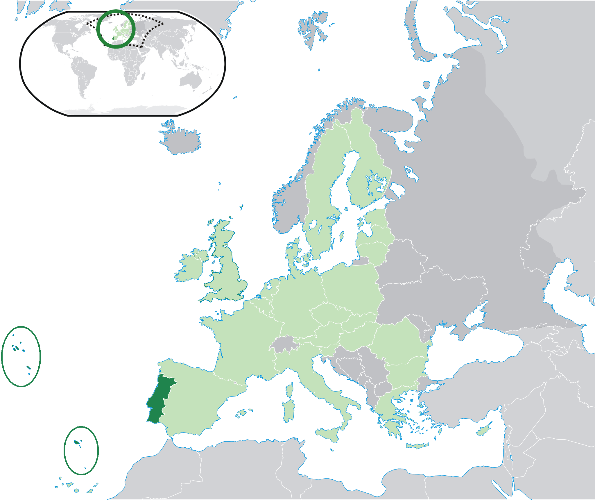
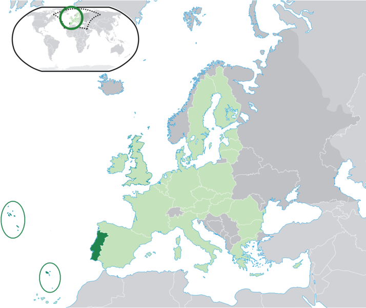
| څرگندونه | Location map: Portugal (dark green) / European Union (light green) / Europe (dark grey); inspired by and consistent with general country locator maps by User:Vardion, et al. |
| نېټه | |
| سرچينه | شخصي اثر |
| ليکوال | Quizimodo |
| نورې بڼې |
|


منښتليک:
| This work has been released into the public domain by its author, I, Quizimodo. This applies worldwide. In some countries this may not be legally possible; if so: I, Quizimodo grants anyone the right to use this work for any purpose, without any conditions, unless such conditions are required by law. |
د دوتنې پېښليک
په يوې نېټې/يوه وخت وټوکۍ چې د هماغه وخت او نېټې دوتنه چې څنگه ښکارېده هماغسې درښکاره شي.
| نېټه/وخت | بټنوک | ډډې | کارن | تبصره | |
|---|---|---|---|---|---|
| اوسنی | ۱۹:۴۷, ۲۶ جولای ۲۰۰۹ | | ۲٬۰۴۸ × ۱٬۷۲۰ (۲۳۹ کيلوبايټ) | The Ogre | Small correction |
| ۱۴:۳۷, ۲۴ جولای ۲۰۰۹ |  | ۲٬۰۴۸ × ۱٬۷۲۰ (۲۴۱ کيلوبايټ) | The Ogre | Still better visivility of islans (in agreement with the fact that the Savage islands ar a part of the Madeira archipelago) | |
| ۱۴:۳۰, ۲۴ جولای ۲۰۰۹ |  | ۲٬۰۴۸ × ۱٬۷۲۰ (۲۴۱ کيلوبايټ) | The Ogre | Better visibility of islands in the Atlantic | |
| ۱۴:۱۳, ۲۴ جولای ۲۰۰۹ |  | ۲٬۰۴۸ × ۱٬۷۲۰ (۲۴۰ کيلوبايټ) | The Ogre | Small corrections - included the islands of Corvo and Flores in the Azores, and the Desertas and Savage islands in Madeira. | |
| ۰۱:۰۶, ۱۸ جون ۲۰۰۷ |  | ۲٬۰۵۶ × ۱٬۷۱۰ (۱۷۶ کيلوبايټ) | Quizimodo~commonswiki | image (updated) | |
| ۱۰:۱۳, ۱۷ جون ۲۰۰۷ |  | ۲٬۰۵۶ × ۱٬۷۱۰ (۲۲۷ کيلوبايټ) | Quizimodo~commonswiki | image (tweaked) | |
| ۱۰:۰۶, ۱۷ جون ۲۰۰۷ |  | ۲٬۰۵۶ × ۱٬۷۱۰ (۲۲۷ کيلوبايټ) | Quizimodo~commonswiki | image (tweaked) | |
| ۰۷:۵۳, ۱۷ جون ۲۰۰۷ |  | ۲٬۰۵۶ × ۱٬۷۱۰ (۲۲۷ کيلوبايټ) | Quizimodo~commonswiki | image (tweaked) | |
| ۰۷:۱۸, ۱۷ جون ۲۰۰۷ |  | ۲٬۰۵۶ × ۱٬۷۱۰ (۲۲۳ کيلوبايټ) | Quizimodo~commonswiki | image (tweaked) | |
| ۰۶:۴۵, ۱۷ جون ۲۰۰۷ |  | ۲٬۰۵۶ × ۱٬۷۱۰ (۲۲۷ کيلوبايټ) | Quizimodo~commonswiki | {{Information |Description=Location map: Portugal (dark green) / European Union (light green) / Europe (dark grey); inspired by and consistent with general country locator maps by User:Vardion, et al |Source=self-made |Date= |Author= [[User:Quizimodo|Quiz |
د دوتنې کارېدنه
داسې هېڅ کوم مخ نه شته چې د دغې دوتنې سره تړنې ولري.
د نړېوالې دوتنې کارېدنه
همدا دوتنه لاندينۍ نورې ويکي گانې کاروي:
- په bcl.wikipedia.org کارونې
- په ceb.wikipedia.org کارونې
- په de.wikinews.org کارونې
- په dv.wikipedia.org کارونې
- په dz.wikipedia.org کارونې
- په es.wikipedia.org کارونې
- په es.wikiquote.org کارونې
- په eu.wiktionary.org کارونې
- په fr.wikipedia.org کارونې
- په gag.wikipedia.org کارونې
- په got.wikipedia.org کارونې
- په gu.wikipedia.org کارونې
- په ka.wikipedia.org کارونې
- په kn.wikipedia.org کارونې
- په ku.wiktionary.org کارونې
- په no.wikipedia.org کارونې
- په pl.wiktionary.org کارونې
- په pt.wikinews.org کارونې
- په ro.wikipedia.org کارونې
- په ro.wikibooks.org کارونې
- په te.wikipedia.org کارونې
- په ug.wikipedia.org کارونې
- په zh-classical.wikipedia.org کارونې