
دوتنه:Westbankjan06.jpg
اصلي دوتنه (۲٬۱۹۹ × ۳٬۶۶۶ پېکسل, د دوتنې کچه: ۱٫۸۴ مېگابايټ, MIME بڼه: image/jpeg)
لنډيز
| څرگندونه |
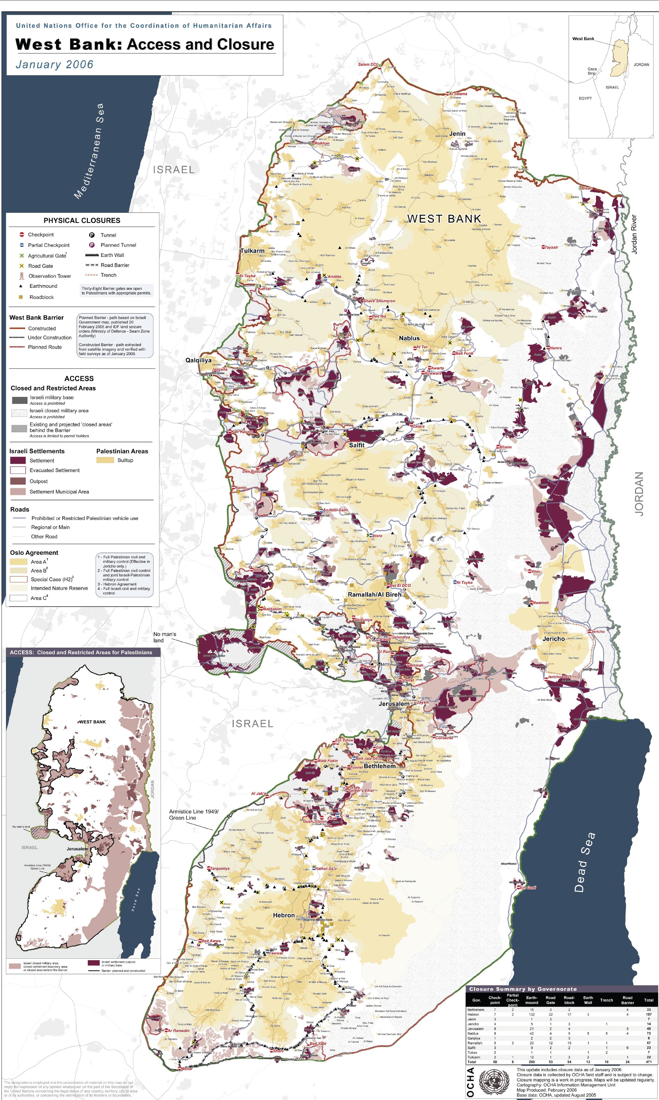
English: Detailed map of Israeli settlements on the West Bank, January 2006. Produced by the United Nations Office for the Coordination of Humanitarian Affairs - public UN source. Map Centre:
العربية: مناطق السلطة الفلسطينية في الضفة الغربية حسب اتفاق أوسلو، حيث يشير اللون الأصفر الغامق (أ) للمناطق ذات السيادة الفلسطينية التامة، بينما اللون الأصفر الفاتح (ب) فهي مناطق ذات سيطرة فلسطينية - إسرائيلية مشتركة، اما اللون الأبيض (ج) فهي مناطق تحت السيطرة الإسرائيلية الأمنية المباشرة. اللون البني يبين التجمعات الاستيطانية الإسرائيلية منذ حرب 1967. بالنسبة لقطاع غزة فهو تحت السيطرة الفلسطينية الكاملة حاليا - بعد انسحاب إسرائيل منه عام 2005 وإخلاء مستوطناتها منه.
|
| نېټه | |
| سرچينه |
United Nations See: Commons:PDF to image files |
| ليکوال | United Nations |
| نورې بڼې |
Derivative works of this file: |

|
This file has been superseded by West Bank Access Restrictions.pdf. It is recommended to use the other file. Please note that deleting superseded images requires consent.
|

|
منښتليک:
| This image is a map derived from a United Nations map.
Unless stated otherwise, UN maps are to be considered in the public domain. This applies worldwide. UN maps are, in principle, open source material and you can use them in your work or for making your own map. UN requests however that you delete the UN name, logo and reference number upon any modification to the map. Content of your map will be your responsibility. You can state in your publication, if you wish, something like: based on UN map … (map name, map number, revision number and date). See: Geospatial Information Section. And: Geospatial, location data for a better world. |
 |
د دوتنې پېښليک
په يوې نېټې/يوه وخت وټوکۍ چې د هماغه وخت او نېټې دوتنه چې څنگه ښکارېده هماغسې درښکاره شي.
| نېټه/وخت | بټنوک | ډډې | کارن | تبصره | |
|---|---|---|---|---|---|
| اوسنی | ۰۹:۱۴, ۲۳ جون ۲۰۰۷ | | ۲٬۱۹۹ × ۳٬۶۶۶ (۱٫۸۴ مېگابايټ) | Oikema 0 | {{Information |Description= |Source= |Date= |Author= |Permission= |other_versions= }} |
د دوتنې کارېدنه
دا لاندينی مخ د همدې دوتنې سره تړنې لري:
د نړېوالې دوتنې کارېدنه
همدا دوتنه لاندينۍ نورې ويکي گانې کاروي:
- په ar.wikipedia.org کارونې
- په ar.wikinews.org کارونې
- په arz.wikipedia.org کارونې
- په ca.wikipedia.org کارونې
- په da.wikipedia.org کارونې
- په de.wikipedia.org کارونې
- په en.wikipedia.org کارونې
- په fa.wikipedia.org کارونې
- په fa.wikivoyage.org کارونې
- په frr.wikipedia.org کارونې
- په glk.wikipedia.org کارونې
- په it.wikipedia.org کارونې
- په it.wikinews.org کارونې
- په ku.wikipedia.org کارونې
- په nl.wikipedia.org کارونې
- په nn.wikipedia.org کارونې
- په no.wikipedia.org کارونې
- په pt.wikipedia.org کارونې
- په ru.wikipedia.org کارونې
- په sk.wikipedia.org کارونې
- په www.wikidata.org کارونې
- په zh-yue.wikipedia.org کارونې
- په zh.wikipedia.org کارونې