
دوتنه:Palestine election map.PNG

د همدې ليدنې کچه: ۴۳۷ × ۶۰۰ پېکسل. نورې ژورليدنې: ۱۷۵ × ۲۴۰ پېکسل | ۳۵۰ × ۴۸۰ پېکسل | ۵۶۰ × ۷۶۸ پېکسل | ۱٬۱۱۵ × ۱٬۵۳۰ پېکسل.
اصلي دوتنه (۱٬۱۱۵ × ۱٬۵۳۰ پېکسل, د دوتنې کچه: ۱۰۶ کيلوبايټ, MIME بڼه: image/png)

|
This election map image could be re-created using vector graphics as an SVG file. This has several advantages; see Commons:Media for cleanup for more information. If an SVG form of this image is available, please upload it and afterwards replace this template with
{{vector version available|new image name}}.
It is recommended to name the SVG file “Palestine election map.svg”—then the template Vector version available (or Vva) does not need the new image name parameter. |
لنډيز
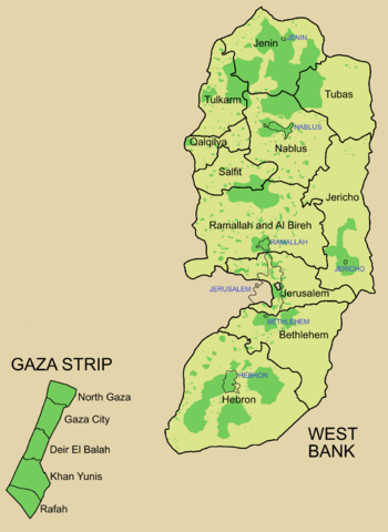
Palestine divided into electoral districts (as of 2006), marked with thick black borders. (thinner borders show boundaries of cities, with city names marked in blue). Green shows areas of formal Palestinian authority. Map made using information from other maps such as this. There is a map of the West Bank and Gaza governates from 1995 here
منښتليک:

|
د دې لاسوند د لمېسلو، وېشلو او/يا هم د بدلولو پرېښه د GNU د وړيا لاسوندکښنې منښتليک 1.2 بڼې او يا هم تر دې نوې بڼې چې د وړيا ساوتريو بنسټ لخوا خپره شوې وي ورکړل شوې، د نابدلېدونکو برخو او د مخ-پوښ او د شا-پوښ د متنونو پرته. د دې منښتليک يوه لمېسه د GNU د وړيا لاسوندکښنې منښتليک په سرليک برخه کې شامل شوی. |
| دا دوتنه د کريټيف کامنز Attribution-Share Alike 3.0 Unported په منښتليک سمبال ده. | ||
| ||
| This licensing tag was added to this file as part of the GFDL licensing update. |
د دوتنې پېښليک
په يوې نېټې/يوه وخت وټوکۍ چې د هماغه وخت او نېټې دوتنه چې څنگه ښکارېده هماغسې درښکاره شي.
| نېټه/وخت | بټنوک | ډډې | کارن | تبصره | |
|---|---|---|---|---|---|
| اوسنی | ۰۹:۵۷, ۵ جولای ۲۰۰۶ | | ۱٬۱۱۵ × ۱٬۵۳۰ (۱۰۶ کيلوبايټ) | Roke~commonswiki | request to make all of gaza strip dark green |
| ۰۵:۳۸, ۲۸ جنوري ۲۰۰۶ |  | ۱٬۱۱۵ × ۱٬۵۳۰ (۱۰۴ کيلوبايټ) | Roke~commonswiki | Palestine divided into electoral districts, marked with black borders. Green shows areas of formal Palestinian authority. I made the map, using information from other maps such as [http://www.nytimes.com/imagepages/2006/01/25/international/20060125_palest |
د دوتنې کارېدنه
دا لاندينی مخ د همدې دوتنې سره تړنې لري:
د نړېوالې دوتنې کارېدنه
همدا دوتنه لاندينۍ نورې ويکي گانې کاروي:
- په arz.wikipedia.org کارونې
- په bcl.wikipedia.org کارونې
- په be.wikipedia.org کارونې
- په bn.wikipedia.org کارونې
- په br.wikipedia.org کارونې
- په ca.wikipedia.org کارونې
- په cs.wikipedia.org کارونې
- په en.wikipedia.org کارونې
- Palestinian territories
- State of Palestine
- List of cities administered by the Palestinian Authority
- Governorates of Palestine
- Template talk:Governorates of the State of Palestine
- Next Palestinian legislative election
- Condoleezza Rice's tenure as Secretary of State
- Talk:Next Palestinian legislative election
- 2006 Palestinian legislative election
- User:Falcaorib
- په en.wikinews.org کارونې
- په eo.wikipedia.org کارونې
- په es.wikipedia.org کارونې
- په es.wikinews.org کارونې
- په fa.wikipedia.org کارونې
- په fr.wikipedia.org کارونې
- په gv.wikipedia.org کارونې
- په he.wikipedia.org کارونې
- په hy.wikipedia.org کارونې
- په id.wikipedia.org کارونې
- په it.wikipedia.org کارونې
- په ja.wikipedia.org کارونې
- په ja.wikinews.org کارونې
- په ko.wikipedia.org کارونې
- په ms.wikipedia.org کارونې
د دې دوتنې نورې نړېوالې کارېدنې کتل.