
دوتنه:Map of Europe (political).png
اصلي دوتنه (۱٬۵۹۶ × ۱٬۰۴۳ پېکسل, د دوتنې کچه: ۸۶ کيلوبايټ, MIME بڼه: image/png)
.png)

|
This map has been uploaded by Electionworld from en.wikipedia.org to enable the |
لنډيز
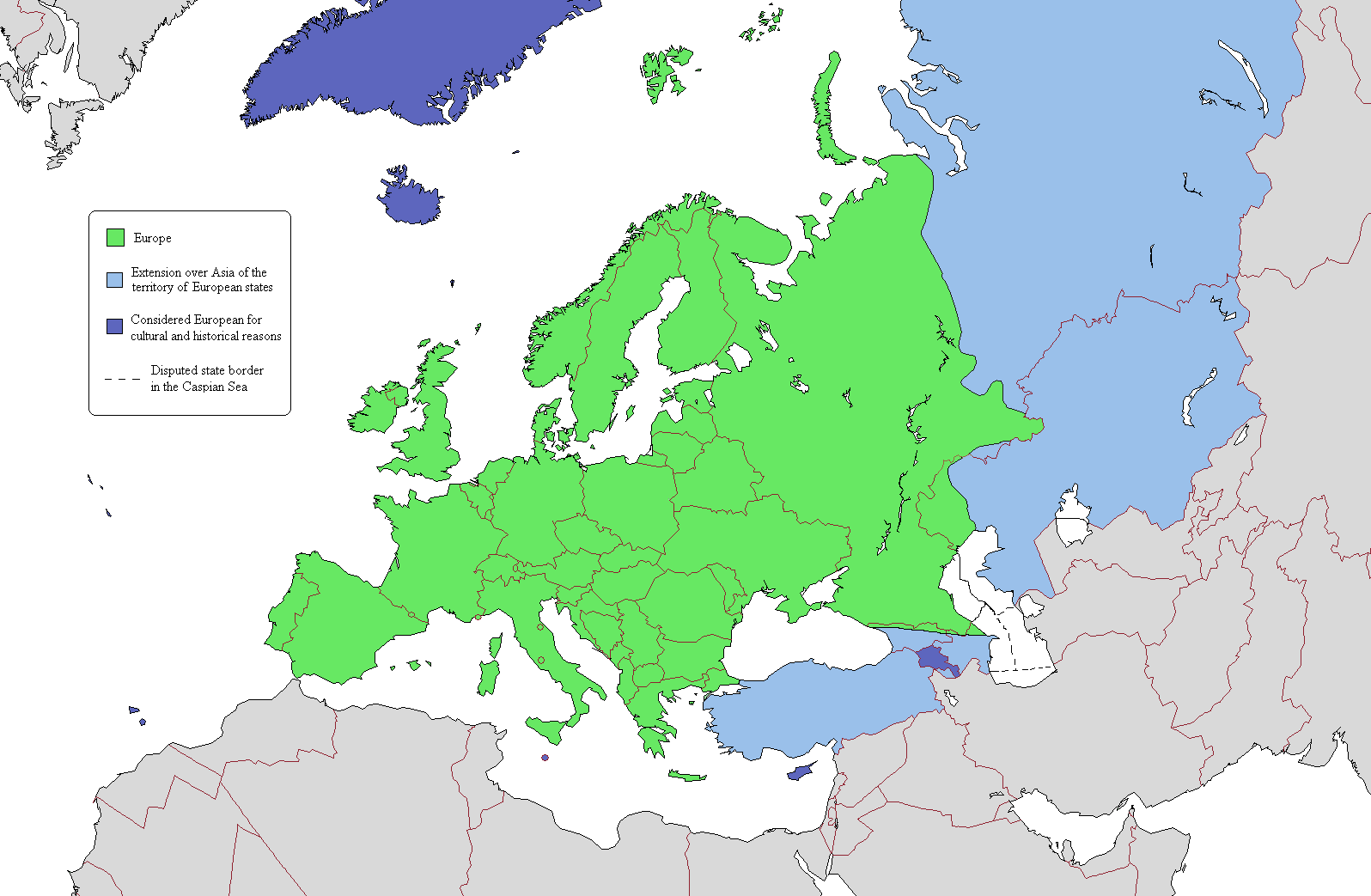
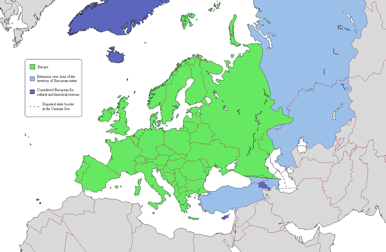
This is a map intended to show the continental boundary of Europe, and the territory of transcontinental states. The map is flawed in a number of ways, and a corrected version is found at [[: File:Europe Asia transcontinental.png]]. Since the latter is a derived version of this one, a copy of the flawed map should be kept around for licencing reasons. The original map appears to have been uploaded to Wikipedia in 2006 by en:User:Alinor.
Derivative works of this file: Europe Asia transcontinental.png
Derivative works of this file: Map of Europe 2007 (political) de.png
_de.png)

|
This map image could be re-created using vector graphics as an SVG file. This has several advantages; see Commons:Media for cleanup for more information. If an SVG form of this image is available, please upload it and afterwards replace this template with
{{vector version available|new image name}}.
It is recommended to name the SVG file “Map of Europe (political).svg”—then the template Vector version available (or Vva) does not need the new image name parameter. |
منښتليک:

|
د دې لاسوند د لمېسلو، وېشلو او/يا هم د بدلولو پرېښه د GNU د وړيا لاسوندکښنې منښتليک 1.2 بڼې او يا هم تر دې نوې بڼې چې د وړيا ساوتريو بنسټ لخوا خپره شوې وي ورکړل شوې، د نابدلېدونکو برخو او د مخ-پوښ او د شا-پوښ د متنونو پرته. د دې منښتليک يوه لمېسه د GNU د وړيا لاسوندکښنې منښتليک په سرليک برخه کې شامل شوی. |
| دا دوتنه د کريټيف کامنز Attribution-Share Alike 3.0 Unported په منښتليک سمبال ده. | ||
| ||
| This licensing tag was added to this file as part of the GFDL licensing update. |
د دوتنې پېښليک
په يوې نېټې/يوه وخت وټوکۍ چې د هماغه وخت او نېټې دوتنه چې څنگه ښکارېده هماغسې درښکاره شي.
.png&dir=prev)
.png&offset=20110409134150)
.png&offset=&limit=20)
.png&offset=&limit=50)
.png&offset=&limit=100)
.png&offset=&limit=250)
.png&offset=&limit=500)
| نېټه/وخت | بټنوک | ډډې | کارن | تبصره | |
|---|---|---|---|---|---|
| اوسنی | ۲۲:۰۳, ۲۰ جون ۲۰۱۹ | | ۱٬۵۹۶ × ۱٬۰۴۳ (۸۶ کيلوبايټ) | Rs4815 | Border in the south-east passes along the Greater Caucasus Range |
| ۰۴:۰۵, ۱۶ اپرېل ۲۰۱۱ |  | ۱٬۵۹۶ × ۱٬۰۴۳ (۱۰۷ کيلوبايټ) | Wsiegmund | Reverted to version as of 19:16, 13 November 2009; see http://commons.wikimedia.org/w/index.php?title=User_talk:Wsiegmund&oldid=53219388#File:Map_of_Europe_.28political.29.png | |
| ۰۳:۲۸, ۱۳ اپرېل ۲۰۱۱ |  | ۱٬۵۹۶ × ۱٬۰۴۳ (۷۱ کيلوبايټ) | Green, White and Gold | Reverted to Dbachmann's version as of 11:49, 8 April 2011 | |
| ۰۲:۳۷, ۱۳ اپرېل ۲۰۱۱ |  | ۱٬۵۹۶ × ۱٬۰۴۳ (۷۱ کيلوبايټ) | Gerge | Reverted to version as of 06:06, 12 April 2011 | |
| ۲۳:۱۲, ۱۲ اپرېل ۲۰۱۱ |  | ۱٬۵۹۶ × ۱٬۰۴۳ (۷۱ کيلوبايټ) | Green, White and Gold | Reverted to Dbachmann's version as of 11:49, 8 April 2011 | |
| ۲۳:۰۹, ۱۲ اپرېل ۲۰۱۱ |  | ۱٬۵۹۶ × ۱٬۰۴۳ (۱۰۷ کيلوبايټ) | Green, White and Gold | Reverted to Dbachmann's version as of 13:41, 9 April 2011 | |
| ۰۶:۰۶, ۱۲ اپرېل ۲۰۱۱ |  | ۱٬۵۹۶ × ۱٬۰۴۳ (۷۱ کيلوبايټ) | Sigismun | Reverted to version as of 19:54, 10 April 2011 | |
| ۰۱:۰۶, ۱۲ اپرېل ۲۰۱۱ |  | ۱٬۵۹۶ × ۱٬۰۴۳ (۱۰۷ کيلوبايټ) | Green, White and Gold | Reverted to Dbachmann's version as of 13:41, 9 April 2011 | |
| ۱۹:۵۴, ۱۰ اپرېل ۲۰۱۱ |  | ۱٬۵۹۶ × ۱٬۰۴۳ (۷۱ کيلوبايټ) | ComtesseDeMingrelie | rv. per Commons:Avoid overwriting existing files | |
| ۱۳:۴۱, ۹ اپرېل ۲۰۱۱ |  | ۱٬۵۹۶ × ۱٬۰۴۳ (۱۰۷ کيلوبايټ) | Dbachmann | so, since this map is going to be useless anyway, rv to 3 February 2009 per "Commons:Avoid overwriting existing files." |
د دوتنې کارېدنه
داسې هېڅ کوم مخ نه شته چې د دغې دوتنې سره تړنې ولري.
د نړېوالې دوتنې کارېدنه
همدا دوتنه لاندينۍ نورې ويکي گانې کاروي:
- په cs.wikipedia.org کارونې
- په da.wikipedia.org کارونې
- په de.wikipedia.org کارونې
- په en.wikipedia.org کارونې
- User:Rashed
- User:Siyavash
- User:Kenzilla
- User:Australian Jezza
- Template:User Eurasian
- User:WiKID Daryl
- User:Royaljared
- User:Angelo De La Paz
- User:PinkPanthress
- Talk:Georgia/Archive 1
- User:Finlandlover
- User talk:BadYodels
- User:Tweisbach
- User:Obaidz96/UBX
- User:Czar Choi
- User:Lenoxus/Subpages/Public/Old
- User:Masumisyan
- User:PKLion
- User:Sweet & Sour Grapes
- User:Shakarian141
- User:Niceguy90
- User:Epileptic Mushroom
- Talk:Armenia/Archive 5
- User:Alexander Rudik
- User:Kunayev
- User:Bush111
- Wikipedia:Graphics Lab/Map workshop/Archive/Apr 2010
- Template talk:Passports/Archive 1
- User:Bgh1111
- User:Lukex115
- User:Lukex115/Userboxen
- User:RussLover
- User:Jextredo
- User:Azndrumsticks
- User:Katangais/Travel
- Wikipedia:Userboxes/Life/Ethnicity
- User:Slawful Justice
- User:Weidorje
- User:Alfredcranham
- User:Chinggis6/Tengerid Traits
- په es.wikipedia.org کارونې
- په fr.wikipedia.org کارونې
- په it.wikipedia.org کارونې
- په ko.wikipedia.org کارونې
- په mk.wikipedia.org کارونې
- په pl.wikipedia.org کارونې
د دې دوتنې نورې نړېوالې کارېدنې کتل.
.png)
.png)