
دوتنه:Map Norway political-geo.png

اصلي دوتنه (۱٬۹۲۰ × ۲٬۹۰۲ پېکسل, د دوتنې کچه: ۹۲۴ کيلوبايټ, MIME بڼه: image/png)
لنډيز
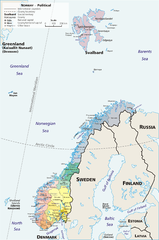
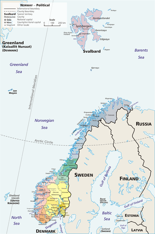
Map: Norway – geopolitical
Exhibits counties (fylker) of Norway (19); colours correspond to regions of Norway:
- yellow: Østlandet (Austlandet)
- orange: Sørlandet
- red: Vestlandet
- green: Trøndelag
- blue: Nord-Norge
Also:
Drawn by E Pluribus Anthony, adapted from:
- Statistics Norway: This is Norway Yearbook, p. 44 (PDF)
- National Geographic Xpeditions Atlas (Map Machine): Norway (PDF)
- Image:Bjornoya map.png

|
This map image could be re-created using vector graphics as an SVG file. This has several advantages; see Commons:Media for cleanup for more information. If an SVG form of this image is available, please upload it and afterwards replace this template with
{{vector version available|new image name}}.
It is recommended to name the SVG file “Map Norway political-geo.svg”—then the template Vector version available (or Vva) does not need the new image name parameter. |
منښتليک:
| This work has been released into the public domain by its author, E Pluribus Anthony. This applies worldwide. In some countries this may not be legally possible; if so: |
Link: http://en.wikipedia.org/wiki/Image:Map_Norway_political-geo.png
derivative works
Derivative works of this file: Jan Mayen ringed.png
د دوتنې پېښليک
په يوې نېټې/يوه وخت وټوکۍ چې د هماغه وخت او نېټې دوتنه چې څنگه ښکارېده هماغسې درښکاره شي.
| نېټه/وخت | بټنوک | ډډې | کارن | تبصره | |
|---|---|---|---|---|---|
| اوسنی | ۰۶:۳۶, ۳۰ جولای ۲۰۱۰ | | ۱٬۹۲۰ × ۲٬۹۰۲ (۹۲۴ کيلوبايټ) | Hayden120 | Restored map proportions to original. |
| ۰۶:۲۶, ۳۰ جولای ۲۰۱۰ |  | ۱٬۹۲۰ × ۲٬۹۰۲ (۱٫۰۴ مېگابايټ) | Hayden120 | Corrected spelling of Trøndelag. | |
| ۱۴:۲۵, ۱ مې ۲۰۰۶ |  | ۱٬۹۲۰ × ۲٬۹۰۲ (۹۶۹ کيلوبايټ) | Mortadelo2005 | == Summary == Map: Norway – geopolitical Exhibits counties (''fylker'') of Norway (19); colours correspond to regions of Norway: * yellow: Østlandet (Austlandet) * orange: Sørlandet * red: Vestlandet * g |
د دوتنې کارېدنه
داسې هېڅ کوم مخ نه شته چې د دغې دوتنې سره تړنې ولري.
د نړېوالې دوتنې کارېدنه
همدا دوتنه لاندينۍ نورې ويکي گانې کاروي:
- په af.wikipedia.org کارونې
- په ang.wikipedia.org کارونې
- په ar.wikipedia.org کارونې
- په ast.wikipedia.org کارونې
- په awa.wikipedia.org کارونې
- په azb.wikipedia.org کارونې
- په az.wikipedia.org کارونې
- په ban.wikipedia.org کارونې
- په be.wikipedia.org کارونې
- په bpy.wikipedia.org کارونې
- په bug.wikipedia.org کارونې
- په ca.wikipedia.org کارونې
- په crh.wikipedia.org کارونې
- په cy.wikipedia.org کارونې
- په da.wikipedia.org کارونې
- په de.wikipedia.org کارونې
- په diq.wikipedia.org کارونې
- په dsb.wikipedia.org کارونې
- په dty.wikipedia.org کارونې
- په el.wikipedia.org کارونې
- په en.wikipedia.org کارونې
- په es.wikipedia.org کارونې
- په es.wikibooks.org کارونې
- په fa.wikipedia.org کارونې
- په fj.wikipedia.org کارونې
- په fo.wikipedia.org کارونې
- په fr.wikipedia.org کارونې
د دې دوتنې نورې نړېوالې کارېدنې کتل.