
دوتنه:Location Austria EU Europe.png

د همدې ليدنې کچه: ۷۲۱ × ۶۰۰ پېکسل. نورې ژورليدنې: ۲۸۹ × ۲۴۰ پېکسل | ۵۷۷ × ۴۸۰ پېکسل | ۹۲۳ × ۷۶۸ پېکسل | ۱٬۲۳۱ × ۱٬۰۲۴ پېکسل | ۲٬۰۵۶ × ۱٬۷۱۰ پېکسل.
اصلي دوتنه (۲٬۰۵۶ × ۱٬۷۱۰ پېکسل, د دوتنې کچه: ۳۲۰ کيلوبايټ, MIME بڼه: image/png)

|
File:EU-Austria.svg is a vector version of this file. It should be used in place of this PNG file when not inferior.
File:Location Austria EU Europe.png → File:EU-Austria.svg
For more information, see Help:SVG. |
 |
لنډيز
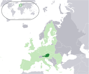
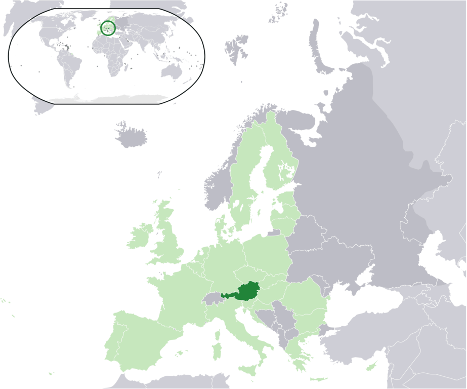
| څرگندونه | Location map: Austria (dark green) / European Union (light green) / Europe (dark grey); inspired by and consistent with general country locator maps by User:Vardion, et al. |
| نېټه | |
| سرچينه | شخصي اثر |
| ليکوال | Quizimodo |
منښتليک:
| This work has been released into the public domain by its author, I, Quizimodo. This applies worldwide. In some countries this may not be legally possible; if so: I, Quizimodo grants anyone the right to use this work for any purpose, without any conditions, unless such conditions are required by law. |
د دوتنې پېښليک
په يوې نېټې/يوه وخت وټوکۍ چې د هماغه وخت او نېټې دوتنه چې څنگه ښکارېده هماغسې درښکاره شي.
| نېټه/وخت | بټنوک | ډډې | کارن | تبصره | |
|---|---|---|---|---|---|
| اوسنی | ۲۱:۲۲, ۱۸ اگسټ ۲۰۱۷ | | ۲٬۰۵۶ × ۱٬۷۱۰ (۳۲۰ کيلوبايټ) | Kontrollstellekundl | added Croatia to EU |
| ۲۱:۱۸, ۱۸ اگسټ ۲۰۱۷ |  | ۲٬۰۵۶ × ۱٬۷۱۰ (۳۲۰ کيلوبايټ) | Kontrollstellekundl | added Croatia | |
| ۰۱:۱۴, ۱۸ جون ۲۰۰۷ |  | ۲٬۰۵۶ × ۱٬۷۱۰ (۱۷۴ کيلوبايټ) | Quizimodo~commonswiki | image (updated) | |
| ۰۹:۴۲, ۱۷ جون ۲۰۰۷ |  | ۲٬۰۵۶ × ۱٬۷۱۰ (۲۲۶ کيلوبايټ) | Quizimodo~commonswiki | image (tweaked) | |
| ۰۷:۲۸, ۱۷ جون ۲۰۰۷ |  | ۲٬۰۵۶ × ۱٬۷۱۰ (۲۲۶ کيلوبايټ) | Quizimodo~commonswiki | image (tweaked) | |
| ۰۷:۱۸, ۱۷ جون ۲۰۰۷ |  | ۲٬۰۵۶ × ۱٬۷۱۰ (۲۲۶ کيلوبايټ) | Quizimodo~commonswiki | {{Information |Description=Location map: Austria (dark green) / European Union (light green) / Europe (dark grey); inspired by and consistent with general country locator maps by User:Vardion, et al |Source=self-made |Date=17 June 2007 |Author= [[User:Qui |
د دوتنې کارېدنه
داسې هېڅ کوم مخ نه شته چې د دغې دوتنې سره تړنې ولري.
د نړېوالې دوتنې کارېدنه
همدا دوتنه لاندينۍ نورې ويکي گانې کاروي:
- په az.wiktionary.org کارونې
- په ceb.wikipedia.org کارونې
- په dz.wikipedia.org کارونې
- په en.wikipedia.org کارونې
- په eu.wiktionary.org کارونې
- په hu.wikipedia.org کارونې
- په it.wikibooks.org کارونې
- په ja.wikipedia.org کارونې
- په ja.wikivoyage.org کارونې
- په kbp.wikipedia.org کارونې
- په kn.wikipedia.org کارونې
- په nl.wikipedia.org کارونې
- په pi.wikipedia.org کارونې
- په pl.wiktionary.org کارونې
- په pt.wikipedia.org کارونې
- په ru.wikipedia.org کارونې