
دوتنه:Karte saarbruecken in deutschland.png
تر دې کچې لوړې بېلن نښې نشته.
Karte_saarbruecken_in_deutschland.png (۱۸۸ × ۲۳۵ پېکسل, د دوتنې کچه: ۵ کيلوبايټ, MIME بڼه: image/png)
لنډيز
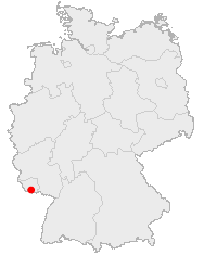
English: Location of Saabruecken in Germany
Lëtzebuergesch: Lag vu Saarbrécken an Däitschland
Zusammenfassung
Lage von Saarbrücken in Deutschland
منښتليک:
This image was generated with OpenGeoDB. The information there is placed in the public domain, images generated from OpenGeoDB are derivative works without passing the threshold of creativity, they are therefore also public domain.
| This work is ineligible for copyright and therefore in the public domain because it consists entirely of information that is common property and contains no original authorship. |
د دوتنې پېښليک
په يوې نېټې/يوه وخت وټوکۍ چې د هماغه وخت او نېټې دوتنه چې څنگه ښکارېده هماغسې درښکاره شي.
| نېټه/وخت | بټنوک | ډډې | کارن | تبصره | |
|---|---|---|---|---|---|
| اوسنی | ۱۶:۱۸, ۲۵ جون ۲۰۰۶ | | ۱۸۸ × ۲۳۵ (۵ کيلوبايټ) | Yassen~commonswiki | english:Location of Saabrucken in Germany<br> deutsch:Lage von Saarbrücken in Deutschland<br> {{GFDL-OpenGeoDB}} Category:Locator_maps_of_cities_in_Germany |
د دوتنې کارېدنه
دا لاندينی مخ د همدې دوتنې سره تړنې لري:
د نړېوالې دوتنې کارېدنه
همدا دوتنه لاندينۍ نورې ويکي گانې کاروي:
- په af.wikipedia.org کارونې
- په azb.wikipedia.org کارونې
- په de.wikipedia.org کارونې
- په de.wikinews.org کارونې
- په fa.wikipedia.org کارونې
- په fy.wikipedia.org کارونې
- په io.wikipedia.org کارونې
- په is.wikipedia.org کارونې
- په ja.wikipedia.org کارونې
- په la.wiktionary.org کارونې
- په lmo.wikipedia.org کارونې
- په pl.wikivoyage.org کارونې
- په pms.wikipedia.org کارونې
- په pnb.wikipedia.org کارونې
- په sq.wikipedia.org کارونې
- په uk.wikipedia.org کارونې
- په zh-yue.wikipedia.org کارونې