
دوتنه:Kaliningrad 05-2017 img10 aerial view.jpg

د همدې ليدنې کچه: ۸۰۰ × ۵۰۰ پېکسل. نورې ژورليدنې: ۳۲۰ × ۲۰۰ پېکسل | ۶۴۰ × ۴۰۰ پېکسل | ۱٬۰۲۴ × ۶۴۰ پېکسل | ۱٬۲۸۰ × ۸۰۰ پېکسل | ۲٬۵۶۰ × ۱٬۶۰۰ پېکسل | ۴٬۳۱۴ × ۲٬۶۹۶ پېکسل.
اصلي دوتنه (۴٬۳۱۴ × ۲٬۶۹۶ پېکسل, د دوتنې کچه: ۵٫۱۶ مېگابايټ, MIME بڼه: image/jpeg)
| څرگندونه |
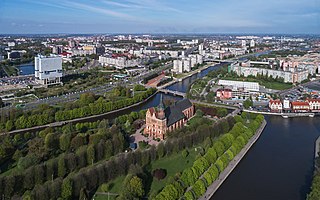
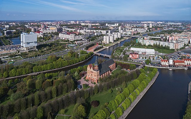
English: Aerial photo, in the foreground: historical Lutheran cathedral in Kaliningrad formerly Königsberg, Kaliningrad Oblast, Russia.
Deutsch: Luftaufnahme, im Vordergrund: ehemaliger Dom in Kaliningrad ehem. Königsberg / Kaliningrader Gebiet, Russland.
Русский: Аэрофотосъёмка города, на переднем плане: исторический кафедральный собор на острове Канта в Калининграде, Россия. |
| نېټه | |
| سرچينه | شخصي اثر |
| ليکوال | A.Savin |
| اجازه (دا دوتنه بيا کارول) |
.svg) Just attribute the author: «A.Savin, Wikipedia»; if you have questions — Telegram, or e-mail to wikiphotospace@gmail.com..svg) Просто укажите в качестве автора: «А.Савин, Википедия»; если есть вопрос — телеграм, или эл.почта на wikiphotospace@gmail.com. Kennzeichnen Sie einfach als Autor: «A.Savin, Wikipedia»; falls Sie Fragen haben — Telegram, oder E-Mail an wikiphotospace@gmail.com.
Thank you. |
| Camera location | | View this and other nearby images on: OpenStreetMap |
|---|
منښتليک:
| Copyleft: This work of art is free; you can redistribute it and/or modify it according to terms of the Free Art License. You will find a specimen of this license on the Copyleft Attitude site as well as on other sites. |
د دوتنې پېښليک
په يوې نېټې/يوه وخت وټوکۍ چې د هماغه وخت او نېټې دوتنه چې څنگه ښکارېده هماغسې درښکاره شي.
| نېټه/وخت | بټنوک | ډډې | کارن | تبصره | |
|---|---|---|---|---|---|
| اوسنی | ۱۴:۳۹, ۱۲ جولای ۲۰۱۷ | | ۴٬۳۱۴ × ۲٬۶۹۶ (۵٫۱۶ مېگابايټ) | A.Savin | {{User:A.Savin/F |Description= {{en|Aerial photo, in the foreground: historical Lutheran cathedral in Kaliningrad formerly Königsberg, Kaliningrad Oblast (Russia).}} {{de|Luftaufnahme, im Vordergrund: ehemaliger Dom in Kaliningrad ehem. Königsberg /... |
د دوتنې کارېدنه
دا لاندينی مخ د همدې دوتنې سره تړنې لري:
د نړېوالې دوتنې کارېدنه
همدا دوتنه لاندينۍ نورې ويکي گانې کاروي:
- په ar.wikipedia.org کارونې
- په arz.wikipedia.org کارونې
- په ast.wikipedia.org کارونې
- په azb.wikipedia.org کارونې
- په az.wikipedia.org کارونې
- په bat-smg.wikipedia.org کارونې
- په be.wikipedia.org کارونې
- په br.wikipedia.org کارونې
- په ca.wikipedia.org کارونې
- په ce.wikipedia.org کارونې
- په ckb.wikipedia.org کارونې
- په crh.wikipedia.org کارونې
- په csb.wikipedia.org کارونې
- په cs.wikipedia.org کارونې
- په cy.wikipedia.org کارونې
- په da.wikipedia.org کارونې
- په de.wikipedia.org کارونې
- په de.wikivoyage.org کارونې
- په diq.wikipedia.org کارونې
- په en.wikipedia.org کارونې
- په en.wikivoyage.org کارونې
- په es.wikipedia.org کارونې
- په eu.wikipedia.org کارونې
- په fr.wikipedia.org کارونې
- په fr.wikivoyage.org کارونې
- په fy.wikipedia.org کارونې
- په ga.wikipedia.org کارونې
- په gl.wikipedia.org کارونې
- په ha.wikipedia.org کارونې
- په he.wikivoyage.org کارونې
- په ie.wikipedia.org کارونې
- په incubator.wikimedia.org کارونې
- په is.wikipedia.org کارونې
- په it.wikipedia.org کارونې
- په ja.wikipedia.org کارونې
- په lij.wikipedia.org کارونې
- په lt.wikipedia.org کارونې
- په mhr.wikipedia.org کارونې
- په myv.wikipedia.org کارونې
- په mzn.wikipedia.org کارونې
- په nl.wikipedia.org کارونې
د دې دوتنې نورې نړېوالې کارېدنې کتل.