دوتنه:Hr-map.png
ښکارېدونکې بڼه
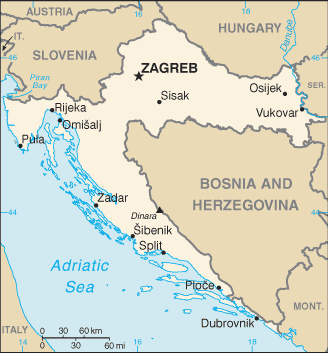
Hr-map.png (۳۲۸ × ۳۵۳ پېکسل, د دوتنې کچه: ۱۵ کيلوبايټ, MIME بڼه: image/png)
د دوتنې پېښليک
په يوې نېټې/يوه وخت وټوکۍ چې د هماغه وخت او نېټې دوتنه چې څنگه ښکارېده هماغسې درښکاره شي.
| نېټه/وخت | بټنوک | ډډې | کارن | تبصره | |
|---|---|---|---|---|---|
| اوسنی | ۰۱:۳۵, ۲۳ اکتوبر ۲۰۰۷ |  | ۳۲۸ × ۳۵۳ (۱۵ کيلوبايټ) | Jeroen | CIA map was overwritten by a UN map, I don't think thats the proper of handle things - btw: UN mao will be uploaded in a while |
| ۰۱:۰۶, ۱۳ مارچ ۲۰۰۷ |  | ۸۹۴ × ۶۸۲ (۱۰۹ کيلوبايټ) | Imbris~commonswiki | UN map of the Republic of Croatia, edited to show correct names of places, and Pelješac on the orriginal is named as an island, not peninsula (it is a peninsula, so green). {{Information |Description=Map of the Republic of Croatia |Source=The Cartogra | |
| ۲۲:۵۹, ۹ مارچ ۲۰۰۷ |  | ۲٬۴۲۵ × ۱٬۸۰۵ (۱٫۰۵ مېگابايټ) | Minestrone | Larger map | |
| ۱۹:۴۵, ۵ مارچ ۲۰۰۷ |  | ۸۹۴ × ۶۸۲ (۱۰۰ کيلوبايټ) | Imbris~commonswiki | {{Information |Description=Map of Croatia |Source=The Cartographic Section of the United Nations (CSUN) |Date=2004-06-15 |Author=Cartographer of the United Nations |Permission={{Template:UN map}} |other_versions= [http://hr.wikipedia.org/wiki/Slika:UN-Zem | |
| ۰۴:۳۵, ۱ جولای ۲۰۰۶ |  | ۳۲۸ × ۳۵۳ (۱۵ کيلوبايټ) | Hoshie | Updated map of Croatia from the CIA World Factbook, 29 June 06 rev. http://www.cia.gov/cia/publications/factbook/maps/hr-map.gif | |
| ۱۴:۵۳, ۳ ډيسمبر ۲۰۰۴ |  | ۳۳۰ × ۳۵۵ (۱۳ کيلوبايټ) | Kneiphof | CIA Croatia map, PD |
د دوتنې کارېدنه
داسې هېڅ کوم مخ نه شته چې د دغې دوتنې سره تړنې ولري.
د نړېوالې دوتنې کارېدنه
همدا دوتنه لاندينۍ نورې ويکي گانې کاروي:
- په az.wikipedia.org کارونې
- په bg.wikipedia.org کارونې
- په bg.wiktionary.org کارونې
- په bs.wikipedia.org کارونې
- په de.wikipedia.org کارونې
- په de.wiktionary.org کارونې
- په dsb.wikipedia.org کارونې
- په en.wikipedia.org کارونې
- په en.wiktionary.org کارونې
- په fi.wikipedia.org کارونې
- په fi.wikivoyage.org کارونې
- په gag.wikipedia.org کارونې
- په hif.wikipedia.org کارونې
- په hr.wikipedia.org کارونې
- په hr.wiktionary.org کارونې
- په hu.wikipedia.org کارونې
- په hu.wiktionary.org کارونې
د دې دوتنې نورې نړېوالې کارېدنې کتل.


