
دوتنه:Golan Heights Map.PNG
تر دې کچې لوړې بېلن نښې نشته.
Golan_Heights_Map.PNG (۴۱۵ × ۳۵۴ پېکسل, د دوتنې کچه: ۱۹ کيلوبايټ, MIME بڼه: image/png)

|
This locator map image could be re-created using vector graphics as an SVG file. This has several advantages; see Commons:Media for cleanup for more information. If an SVG form of this image is available, please upload it and afterwards replace this template with
{{vector version available|new image name}}.
It is recommended to name the SVG file “Golan Heights Map.svg”—then the template Vector version available (or Vva) does not need the new image name parameter. |
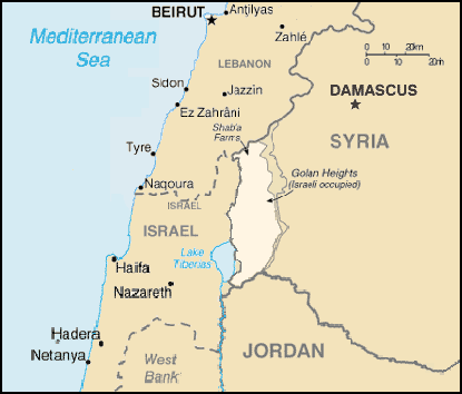
A map of the Golan Heights, made entirely of info from the CIA World Factbook. If this is even elligible for copyright, I hereby release it into the public domain.
This image is in the public domain because it contains materials that originally came from the United States Central Intelligence Agency's World Factbook.
|
 |
د دوتنې پېښليک
په يوې نېټې/يوه وخت وټوکۍ چې د هماغه وخت او نېټې دوتنه چې څنگه ښکارېده هماغسې درښکاره شي.
| نېټه/وخت | بټنوک | ډډې | کارن | تبصره | |
|---|---|---|---|---|---|
| اوسنی | ۲۰:۵۸, ۲۸ جون ۲۰۰۵ | | ۴۱۵ × ۳۵۴ (۱۹ کيلوبايټ) | Quadell | A map of the Golan Heights, made entirely of info from the CIA World Factbook. If this is even elligible for copyright, I hereby release it into the public domain. {{PD-USGov-CIA-WF}} Category:Maps of Israel Category:Maps of Syria |
د دوتنې کارېدنه
دا لاندينی مخ د همدې دوتنې سره تړنې لري:
د نړېوالې دوتنې کارېدنه
همدا دوتنه لاندينۍ نورې ويکي گانې کاروي:
- په af.wikipedia.org کارونې
- په ang.wikipedia.org کارونې
- په ar.wikipedia.org کارونې
- په azb.wikipedia.org کارونې
- په bn.wikipedia.org کارونې
- په ca.wikipedia.org کارونې
- Resolució 429 del Consell de Seguretat de les Nacions Unides
- Resolució 441 del Consell de Seguretat de les Nacions Unides
- Resolució 449 del Consell de Seguretat de les Nacions Unides
- Resolució 456 del Consell de Seguretat de les Nacions Unides
- Resolució 470 del Consell de Seguretat de les Nacions Unides
- Resolució 485 del Consell de Seguretat de les Nacions Unides
- Resolució 493 del Consell de Seguretat de les Nacions Unides
- Resolució 497 del Consell de Seguretat de les Nacions Unides
- Resolució 506 del Consell de Seguretat de les Nacions Unides
- Resolució 524 del Consell de Seguretat de les Nacions Unides
- Resolució 563 del Consell de Seguretat de les Nacions Unides
- Resolució 613 del Consell de Seguretat de les Nacions Unides
- Resolució 645 del Consell de Seguretat de les Nacions Unides
- په ckb.wikipedia.org کارونې
- بڕیارنامەی ٤٢٩ی ئەنجومەنی ئاسایش
- بڕیارنامەی ٤٤٩ی ئەنجومەنی ئاسایش
- بڕیارنامەی ٤٥٦ی ئەنجومەنی ئاسایش
- بڕیارنامەی ٤٧٠ی ئەنجومەنی ئاسایش
- بڕیارنامەی ٤٨١ی ئەنجومەنی ئاسایش
- بڕیارنامەی ٤٨٥ی ئەنجومەنی ئاسایش
- بڕیارنامەی ٤٩٣ی ئەنجومەنی ئاسایش
- بڕیارنامەی ٤٩٧ی ئەنجومەنی ئاسایش
- بڕیارنامەی ٥٠٦ی ئەنجومەنی ئاسایش
- بڕیارنامەی ٥٢٤ی ئەنجومەنی ئاسایش
- بڕیارنامەی ٥٣١ی ئەنجومەنی ئاسایش
- بڕیارنامەی ٥٤٣ی ئەنجومەنی ئاسایش
- بڕیارنامەی ٥٥١ی ئەنجومەنی ئاسایش
- بڕیارنامەی ٥٥٧ی ئەنجومەنی ئاسایش
- بڕیارنامەی ٥٦٣ی ئەنجومەنی ئاسایش
- بڕیارنامەی ٥٧٦ی ئەنجومەنی ئاسایش
- بڕیارنامەی ٥٨٤ی ئەنجومەنی ئاسایش
- بڕیارنامەی ٥٩٠ی ئەنجومەنی ئاسایش
- بڕیارنامەی ٦٠٣ی ئەنجومەنی ئاسایش
- بڕیارنامەی ٦١٣ی ئەنجومەنی ئاسایش
- بڕیارنامەی ٦٢٤ی ئەنجومەنی ئاسایش
- بڕیارنامەی ٦٤٥ی ئەنجومەنی ئاسایش
- بەرزایییەکانی جۆلان
- په cs.wikipedia.org کارونې
- په en.wikipedia.org کارونې
- United Nations Security Council Resolution 497
- Golan Heights
- United Nations Security Council Resolution 429
- United Nations Security Council Resolution 441
- United Nations Security Council Resolution 449
- United Nations Security Council Resolution 456
- United Nations Security Council Resolution 470
- United Nations Security Council Resolution 481
د دې دوتنې نورې نړېوالې کارېدنې کتل.