دوتنه:Gibraltar map-en.svg
Page contents not supported in other languages.
د ويکيپېډيا، وړیا پوهنغونډ له خوا

اصلي دوتنه(SVG دوتنه، نومېنلي ۲٬۰۲۰ × ۳٬۱۴۰ پېکسل، د دوتنې کچه: ۲۸۹ کيلوبايټ)

دا دوتنه د ويکيمېډيا کامنز لخوا خپرېږې او کېدای شي چې دا په نورو پروژو هم کارېدلې وي. د دوتنې د کارېدنې لا نور مالومات د دوتنې د څرگندنو په مخ کې لاندې ښودل شوی.

Image of the year
Image of the year
Featured image

ويکيخونديځ

This file was a candidate in Picture of the Year 2007.
This is a featured picture on Wikimedia Commons (Featured pictures) and is considered one of the finest images. See its nomination here.

If you have an image of similar quality that can be published under a suitable copyright license, be sure to upload it, tag it, and nominate it.

لنډيز

Camera location۳۶° ۰۸′ ۰۰″ N, ۵° ۲۱′ ۰۰″ W Kartographer map based on OpenStreetMap.View this and other nearby images on: OpenStreetMapinfo
څرگندونه
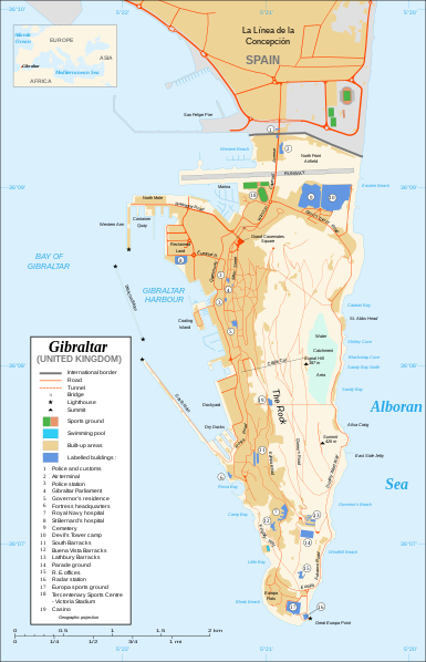
Čeština: Mapa ostrova Gibraltar v angličtině.
English: Map in English of Gibraltar.
Français : * Sujet : Carte en anglais de Gibraltar ;
  • Sources : Création personnelle ;
  • Carte créée à partir de captures d'écran d'images satellite de Google Earth d'un point de vue placé à 1,18 km d'altitude (imagerie disponible de novembre 2007) ;
  • Références complémentaires :
  • Échelle approximative : 1:40 000 (précision : environ 10 m) ;
  • Note : Largeur du tracé des routes proportionnelle à la réalité ;
  • Auteur : Eric Gaba (fr:Sting) ;
  • Date : Novembre 2007.
Português: Mapa (em Inglês) de Gibraltar.
نېټه
سرچينه Own work ;
Map created using screenshots of Google Earth satellite imagery from a point of view located at 1.18 km of altitude (available imagery of November 2007) ;
Other references :
* CIA map ;
* Gibnet map ;
* U.K. MoD map
Locator map : Image:Blank_map_of_South_Europe_and_North_Africa.svg (modified) created by Historicair ;
Approximate scale : 1:40,000 (accuracy : about 10 m)
Note : The roads width is proportional to reality
ليکوال Eric Gaba (Sting)
اجازه
(دا دوتنه بيا کارول)
Attribution and Share-Alike required
نورې بڼې

[سمول]

Disputed isthmus and land
SVG genesis
InfoField
 
The SVG code is valid.
 
This map was created with Inkscape…important.
 
 This map uses embedded text that can be easily translated using a text editor.

منښتليک:

I, the copyright holder of this work, hereby publish it under the following licenses:
GNU head د دې لاسوند د لمېسلو، وېشلو او/يا هم د بدلولو پرېښه د GNU د وړيا لاسوندکښنې منښتليک 1.2 بڼې او يا هم تر دې نوې بڼې چې د وړيا ساوتريو بنسټ لخوا خپره شوې وي ورکړل شوې، د نابدلېدونکو برخو او د مخ-پوښ او د شا-پوښ د متنونو پرته. د دې منښتليک يوه لمېسه د GNU د وړيا لاسوندکښنې منښتليک په سرليک برخه کې شامل شوی.
w:ps:کريېټيو کامانز
اړوندېدنه يوشان شريکول
This file is licensed under the Creative Commons Attribution-Share Alike Attribution-Share Alike 4.0 International, 3.0 Unported, 2.5 Generic, 2.0 Generic and 1.0 Generic license.
تاسې کولی شئ چې:
  • بيا يې د نورو سره شريک کړئ – همدا اثر ولمېسئ، و وېشئ او بيا يې خپور کړئ
  • بيا ادلون بدلون راولئ – بدل شوی اثر خپل کړئ
د لاندې شرطونو له مخې:
  • اړوندېدنه – تاسې بايد دا اثر د ليکوال يا منښتگر لخوا د ځانگړو شويو اصولو سره اړونده وگڼئ (خو په دې توگه نه چې داسې ښکاره شي چې گنې تاسې يا ستاسې لخوا کارېدنه د اثر د ملاتړ سبب شوی)
  • يوشان شريکول – که تاسې همدا اثر بدلوئ، رغوئ، او يا يې هم سر له نوي جوړوئ نو په پايله کې رامېنځ ته شوی اثر به يوازې د همدې دوتنې ورته منښتليک پر بنسټ خپروئ.
تاسې د خپلې خوښې منښتليک ټاکلی شی.

Captions

Add a one-line explanation of what this file represents

Items portrayed in this file

depicts انګليسي

copyright status انګليسي

copyrighted انګليسي

36°7'59.999"N, 5°21'0.000"W

media type انګليسي

image/svg+xml

د دوتنې پېښليک

په يوې نېټې/يوه وخت وټوکۍ چې د هماغه وخت او نېټې دوتنه چې څنگه ښکارېده هماغسې درښکاره شي.

نېټه/وختبټنوکډډېکارنتبصره
اوسنی۲۰:۱۰, ۲۱ فبروري ۲۰۲۰د ۲۰:۱۰, ۲۱ فبروري ۲۰۲۰ پورې د بټنوک بڼه۲٬۰۲۰ × ۳٬۱۴۰ (۲۸۹ کيلوبايټ)JoKalliauermalformed svg (compare firefox/chrome rendering with librsvg-rendering) actually firefox/chrome were correct, also it looks wrong
۰۶:۰۱, ۲۹ جون ۲۰۱۷د ۰۶:۰۱, ۲۹ جون ۲۰۱۷ پورې د بټنوک بڼه۲٬۰۲۰ × ۳٬۱۴۰ (۵۳۸ کيلوبايټ)Wereldburger758Removal error in file. Valid SVG now.
۲۱:۵۲, ۲۷ اگسټ ۲۰۰۸د ۲۱:۵۲, ۲۷ اگسټ ۲۰۰۸ پورې د بټنوک بڼه۲٬۰۲۰ × ۳٬۱۴۰ (۵۶۹ کيلوبايټ)RedCoatRemove "claimed by Spain", completely gratuitous for a map
۱۱:۲۸, ۱۱ ډيسمبر ۲۰۰۷د ۱۱:۲۸, ۱۱ ډيسمبر ۲۰۰۷ پورې د بټنوک بڼه۲٬۰۲۰ × ۳٬۱۴۰ (۵۷۰ کيلوبايټ)StingNotification of the Spanish claims
۱۴:۴۰, ۲۷ نومبر ۲۰۰۷د ۱۴:۴۰, ۲۷ نومبر ۲۰۰۷ پورې د بټنوک بڼه۲٬۰۲۰ × ۳٬۱۴۰ (۵۶۹ کيلوبايټ)StingAdditional names ; up-to-date corrections
۲۱:۳۵, ۲۶ نومبر ۲۰۰۷د ۲۱:۳۵, ۲۶ نومبر ۲۰۰۷ پورې د بټنوک بڼه۲٬۰۲۰ × ۳٬۱۴۰ (۵۶۱ کيلوبايټ)RedCoatHouse of Assembly → Gibraltar Parliament
۱۹:۵۱, ۲۶ نومبر ۲۰۰۷د ۱۹:۵۱, ۲۶ نومبر ۲۰۰۷ پورې د بټنوک بڼه۲٬۰۲۰ × ۳٬۱۴۰ (۵۶۱ کيلوبايټ)Sting+ info
۱۴:۱۲, ۲۶ نومبر ۲۰۰۷د ۱۴:۱۲, ۲۶ نومبر ۲۰۰۷ پورې د بټنوک بڼه۲٬۰۲۰ × ۳٬۱۴۰ (۵۶۱ کيلوبايټ)Sting+ info
۱۳:۲۱, ۲۶ نومبر ۲۰۰۷د ۱۳:۲۱, ۲۶ نومبر ۲۰۰۷ پورې د بټنوک بڼه۲٬۰۲۰ × ۳٬۱۴۰ (۵۶۱ کيلوبايټ)Sting{{Information |Description=Map in English of Gibraltar |Source=Own work ;<br/>Map created using screenshots of Google Earth satellite imagery from a point of view located at 1.18 km of altitude (available image

داسې هېڅ کوم مخ نه شته چې د دغې دوتنې سره تړنې ولري.

د نړېوالې دوتنې کارېدنه

همدا دوتنه لاندينۍ نورې ويکي گانې کاروي:

مېټاډاټا