
دوتنه:Floristic regions in Europe (english).png

د همدې ليدنې کچه: ۷۵۱ × ۶۰۰ پېکسل. نورې ژورليدنې: ۳۰۱ × ۲۴۰ پېکسل | ۶۰۱ × ۴۸۰ پېکسل | ۹۶۲ × ۷۶۸ پېکسل | ۱٬۲۸۰ × ۱٬۰۲۲ پېکسل | ۱٬۷۹۷ × ۱٬۴۳۵ پېکسل.
اصلي دوتنه (۱٬۷۹۷ × ۱٬۴۳۵ پېکسل, د دوتنې کچه: ۱٫۹۵ مېگابايټ, MIME بڼه: image/png)
.png)
لنډيز
| څرگندونه |
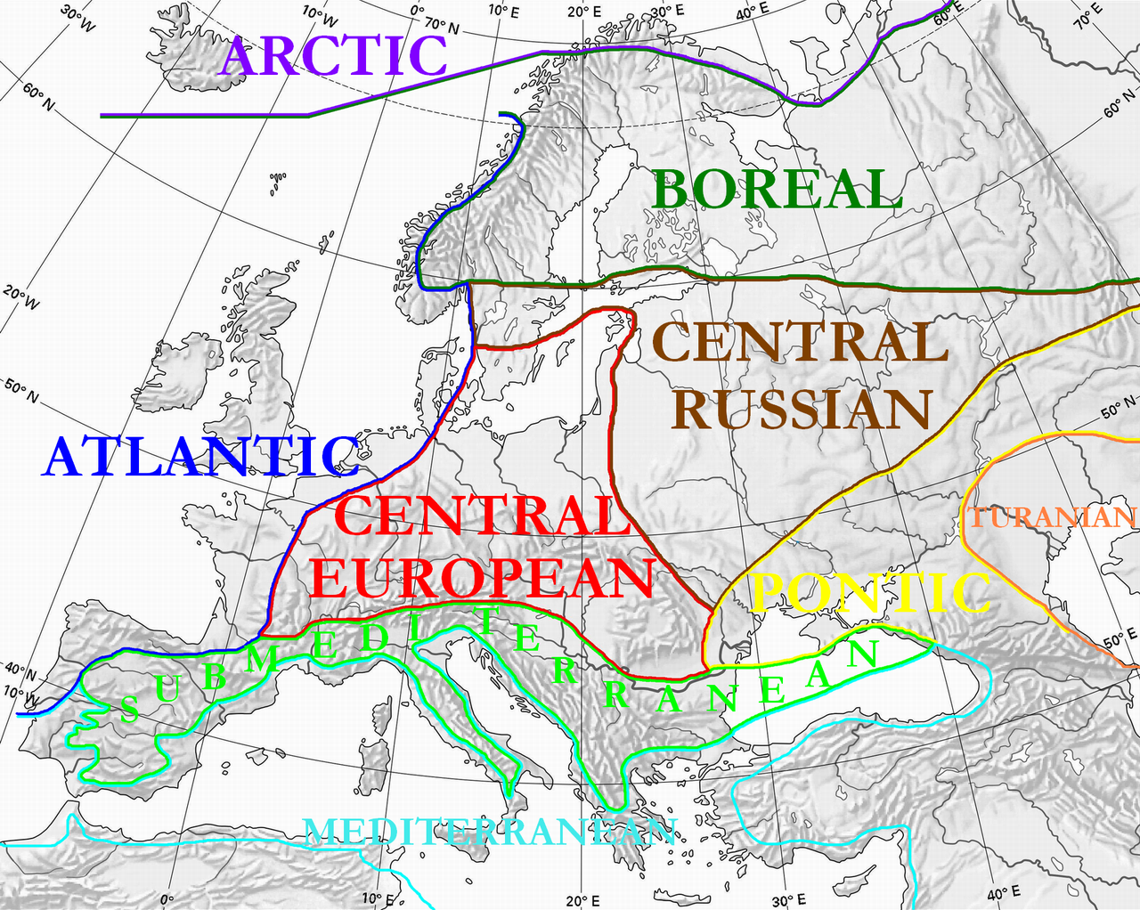
English: Floristic regions in Europe and western Siberia, according to Wolfgang Frey and Rainer Lösch
Français : Régions floristiques européennes actuelles (Europe et Siberie occidentale), selon Wolfgang Frey et Rainer Lösch |
| نېټه | |
| سرچينه | شخصي اثر |
| ليکوال | User:Olahus |
| نورې بڼې | Derivative works of this file: Floristic regions in Europe-de.png |

|
This biogeographical map image could be re-created using vector graphics as an SVG file. This has several advantages; see Commons:Media for cleanup for more information. If an SVG form of this image is available, please upload it and afterwards replace this template with
{{vector version available|new image name}}.
It is recommended to name the SVG file “Floristic regions in Europe (english).svg”—then the template Vector version available (or Vva) does not need the new image name parameter. |
منښتليک:
| I, the copyright holder of this work, release this work into the public domain. This applies worldwide. In some countries this may not be legally possible; if so: I grant anyone the right to use this work for any purpose, without any conditions, unless such conditions are required by law. |
د دوتنې پېښليک
په يوې نېټې/يوه وخت وټوکۍ چې د هماغه وخت او نېټې دوتنه چې څنگه ښکارېده هماغسې درښکاره شي.
| نېټه/وخت | بټنوک | ډډې | کارن | تبصره | |
|---|---|---|---|---|---|
| اوسنی | ۰۰:۳۶, ۳ جولای ۲۰۱۰ | | ۱٬۷۹۷ × ۱٬۴۳۵ (۱٫۹۵ مېگابايټ) | Ras67 | cropped |
| ۲۲:۱۵, ۲۸ مارچ ۲۰۰۸ |  | ۱٬۸۰۰ × ۱٬۴۴۲ (۲٫۱۷ مېگابايټ) | Olahus | {{Information |Description=Floristic regions in Europe and western Siberia, according to Wolfgang Frey and Rainer Lösch |Source=own work |Date=2008 |Author= Olahus |Permission= |other_versions= }} |
د دوتنې کارېدنه
داسې هېڅ کوم مخ نه شته چې د دغې دوتنې سره تړنې ولري.
د نړېوالې دوتنې کارېدنه
همدا دوتنه لاندينۍ نورې ويکي گانې کاروي:
- په ar.wikipedia.org کارونې
- په bn.wikipedia.org کارونې
- په br.wikipedia.org کارونې
- په bs.wikipedia.org کارونې
- په ca.wikipedia.org کارونې
- په cs.wikipedia.org کارونې
- په el.wikipedia.org کارونې
- په en.wikipedia.org کارونې
- په eo.wikipedia.org کارونې
- په es.wikipedia.org کارونې
- په fa.wikipedia.org کارونې
- په fi.wikipedia.org کارونې
- په frp.wikipedia.org کارونې
- په fr.wikipedia.org کارونې
- په gl.wikipedia.org کارونې
- په hi.wikipedia.org کارونې
- په hu.wikipedia.org کارونې
- په hy.wikipedia.org کارونې
- په it.wikipedia.org کارونې
- په ja.wikipedia.org کارونې
- په kk.wikipedia.org کارونې
- په ko.wikipedia.org کارونې
د دې دوتنې نورې نړېوالې کارېدنې کتل.
.png)
.png)