
دوتنه:British Columbia-map.png
تر دې کچې لوړې بېلن نښې نشته.
British_Columbia-map.png (۲۸۰ × ۲۳۰ پېکسل, د دوتنې کچه: ۱۴ کيلوبايټ, MIME بڼه: image/png)

|
File:British Columbia, Canada.svg is a vector version of this file. It should be used in place of this PNG file when not inferior.
File:British Columbia-map.png → File:British Columbia, Canada.svg
For more information, see Help:SVG. |
 |
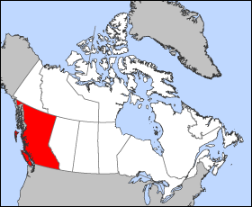
Map of British Columbia
Projection: Lambert azimuthal equal-area
Geospatial data from: The Atlas of Canada, The National Atlas of the United States archive copy at the Wayback Machine and U.S. Geological Survey
Cartographer: John Fowler
| I, the copyright holder of this work, release this work into the public domain. This applies worldwide. In some countries this may not be legally possible; if so: I grant anyone the right to use this work for any purpose, without any conditions, unless such conditions are required by law. |
د دوتنې پېښليک
په يوې نېټې/يوه وخت وټوکۍ چې د هماغه وخت او نېټې دوتنه چې څنگه ښکارېده هماغسې درښکاره شي.
| نېټه/وخت | بټنوک | ډډې | کارن | تبصره | |
|---|---|---|---|---|---|
| اوسنی | ۱۲:۱۲, ۲۴ مارچ ۲۰۰۵ | | ۲۸۰ × ۲۳۰ (۱۴ کيلوبايټ) | Voyager | Map of British Columbia Projection: Lambert azimuthal equal-area Geospatial data from: [http://atlas.gc.ca/ The Atlas of Canada], [http://www.nationalatlas.gov/ The National Atlas of the United States] and [http://www.usgs.gov U.S. Geological Survey] C |
د دوتنې کارېدنه
داسې هېڅ کوم مخ نه شته چې د دغې دوتنې سره تړنې ولري.
د نړېوالې دوتنې کارېدنه
همدا دوتنه لاندينۍ نورې ويکي گانې کاروي:
- په fr.wikipedia.org کارونې
- په he.wikivoyage.org کارونې