
دوتنه:BlankMap-World-Subdivisions.PNG
د همدې ليدنې کچه: ۸۰۰ × ۳۹۵ پېکسل. نورې ژورليدنې: ۳۲۰ × ۱۵۸ پېکسل | ۶۴۰ × ۳۱۶ پېکسل | ۱٬۵۰۰ × ۷۴۰ پېکسل.
اصلي دوتنه (۱٬۵۰۰ × ۷۴۰ پېکسل, د دوتنې کچه: ۱۱۸ کيلوبايټ, MIME بڼه: image/png)

|
File:Blank Map World Secondary Political Divisions.svg is a vector version of this file. It should be used in place of this PNG file when not inferior.
File:BlankMap-World-Subdivisions.PNG → File:Blank Map World Secondary Political Divisions.svg
For more information, see Help:SVG. |
 |
h
لنډيز
| څرگندونه |
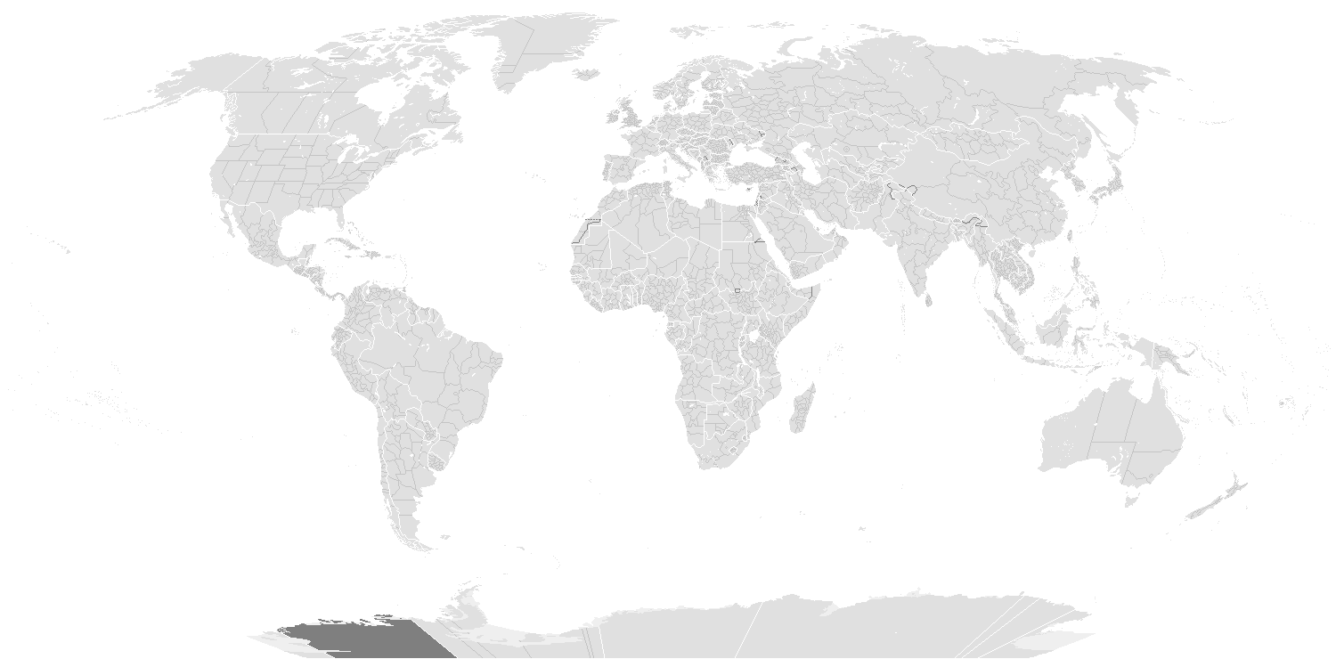
English: A blank world map showing subdivisions of the world. Areas in black boxes are unrecognized countries or disputed territories (Kashmir). Feel free to fix subdivisions (mainly Russia, Mongolia, and Kazakhstan. If you use the subdivision maps for any other image I strongly advise changing the subdivision colours to suit your purposes (eg. In Photoshop use the bucket of paint thing with contiguous and anti-alias turned off and click on any subdivision border with your preferred colour.) The colours chosen here are to differentiate the types of borders, not dictate use.
Français : Carte du monde vierge montrant les subdivisions de premier niveau de chaque pays. Les régions encadrées en noir montrent des États non reconnus ou des territoires disputés (comme le Cachemire. Ne vous gênez pas pour arranger certaines limites de subdivisions — notamment en Russie, en Mongolie et au Kazakhstan. Si vous utilisez cette carte pour faire une autre image, il vous est vivement conseillé d’en changer les couleurs pour qu’elles conviennent à votre usage ; ces couleurs-ci ne sont choisies que pour distinguer les différents types de frontières. |
||
| نېټه | |||
| سرچينه |
|
||
| ليکوال |
English: see upload log? |
||
| اجازه (دا دوتنه بيا کارول) |
|
||
| نورې بڼې | Derivative works of this file: BlankMap-World-Subdivisions1.png |
Key
|
Water-bodies
Landmasses
Unclaimed Landmasses
National Borders
Subnational Borders
|
Colours
| Name | Decimal | Hex | |
| Water-bodies: | 255,255,255 | #FFFFFF | |
| Landmasses: | 224,224,224 | #E0E0E0 | |
| Unclaimed Landmasses: | 127,127,127 | #7F7F7F | |
| National Borders: | 255,255,255 | #FFFjjj | |
| Subnational Borders: | 202,202,202 | #CACACA |
| Annotations | This image is annotated: View the annotations at Commons |
د دوتنې پېښليک
په يوې نېټې/يوه وخت وټوکۍ چې د هماغه وخت او نېټې دوتنه چې څنگه ښکارېده هماغسې درښکاره شي.
| نېټه/وخت | بټنوک | ډډې | کارن | تبصره | |
|---|---|---|---|---|---|
| اوسنی | ۲۲:۳۶, ۱۴ مارچ ۲۰۲۰ | | ۱٬۵۰۰ × ۷۴۰ (۱۱۸ کيلوبايټ) | Dylmur | Reverted to version as of 18:58, 14 March 2020 (UTC) hopefully this works again |
| ۱۹:۰۰, ۱۴ مارچ ۲۰۲۰ |  | ۱٬۵۰۰ × ۷۴۰ (۹۱ کيلوبايټ) | Dylmur | Reverted to version as of 00:56, 29 October 2017 (UTC) didn’t work | |
| ۱۸:۵۸, ۱۴ مارچ ۲۰۲۰ |  | ۱٬۵۰۰ × ۷۴۰ (۱۱۸ کيلوبايټ) | Dylmur | Ladakh (2019) | |
| ۰۰:۵۶, ۲۹ اکتوبر ۲۰۱۷ |  | ۱٬۵۰۰ × ۷۴۰ (۹۱ کيلوبايټ) | Erhik | Golan Heights | |
| ۰۰:۲۵, ۲۹ اکتوبر ۲۰۱۷ |  | ۱٬۵۰۰ × ۷۴۰ (۹۱ کيلوبايټ) | Erhik | Minor adjustments in Oceania, Ukraine. | |
| ۱۱:۲۷, ۱۰ اکتوبر ۲۰۱۷ |  | ۱٬۵۰۰ × ۷۴۰ (۱۰۴ کيلوبايټ) | Expertseeker90 | Major overhall to the projection! Continents, coastlines, national boundary and internal boundaries fixed. Islands, atolls and reefs added or adjusted! | |
| ۲۱:۳۴, ۴ جولای ۲۰۱۷ |  | ۱٬۵۰۰ × ۷۴۰ (۱۰۰ کيلوبايټ) | Forthrunner | Catalonia isn't independent | |
| ۰۹:۴۷, ۲۱ جولای ۲۰۱۶ |  | ۱٬۵۰۰ × ۷۴۰ (۶۷ کيلوبايټ) | Simonsyo | Added British Regions. | |
| ۱۸:۲۱, ۱۹ جنوري ۲۰۱۶ |  | ۱٬۵۰۰ × ۷۴۰ (۶۷ کيلوبايټ) | Userboker | Added new French regions as of 2016, fixed Catalonia being represented as independent | |
| ۱۴:۵۸, ۱۶ ډيسمبر ۲۰۱۴ |  | ۱٬۵۰۰ × ۷۴۰ (۸۳ کيلوبايټ) | Ransewiki | Did not work last time. |
د دوتنې کارېدنه
داسې هېڅ کوم مخ نه شته چې د دغې دوتنې سره تړنې ولري.
د نړېوالې دوتنې کارېدنه
همدا دوتنه لاندينۍ نورې ويکي گانې کاروي:
- په de.wikipedia.org کارونې
- Vorwahlergebnisse der Präsidentschaftswahl in den Vereinigten Staaten 2008
- Vorwahlergebnisse der Präsidentschaftswahl in den Vereinigten Staaten 2016
- Vorwahlergebnisse der Präsidentschaftswahl in den Vereinigten Staaten 2020
- Vorwahlergebnisse der Präsidentschaftswahl in den Vereinigten Staaten 2024
- Benutzer:Sarkana/Vorwahlergebnisse 2024
- په en.wikipedia.org کارونې
- په fr.wikipedia.org کارونې
- په sv.wikipedia.org کارونې
- په zh.wikipedia.org کارونې