
دوتنه:Asian Highways.png

د همدې ليدنې کچه: ۴۵۳ × ۵۹۹ پېکسل. نورې ژورليدنې: ۱۸۱ × ۲۴۰ پېکسل | ۳۶۳ × ۴۸۰ پېکسل | ۵۸۱ × ۷۶۸ پېکسل | ۷۷۵ × ۱٬۰۲۴ پېکسل | ۲٬۰۲۶ × ۲٬۶۷۸ پېکسل.
اصلي دوتنه (۲٬۰۲۶ × ۲٬۶۷۸ پېکسل, د دوتنې کچه: ۶٫۸۵ مېگابايټ, MIME بڼه: image/png)
| This work has been released into the public domain by its author, SPUI. This applies worldwide. In some countries this may not be legally possible; if so: |
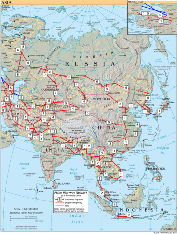
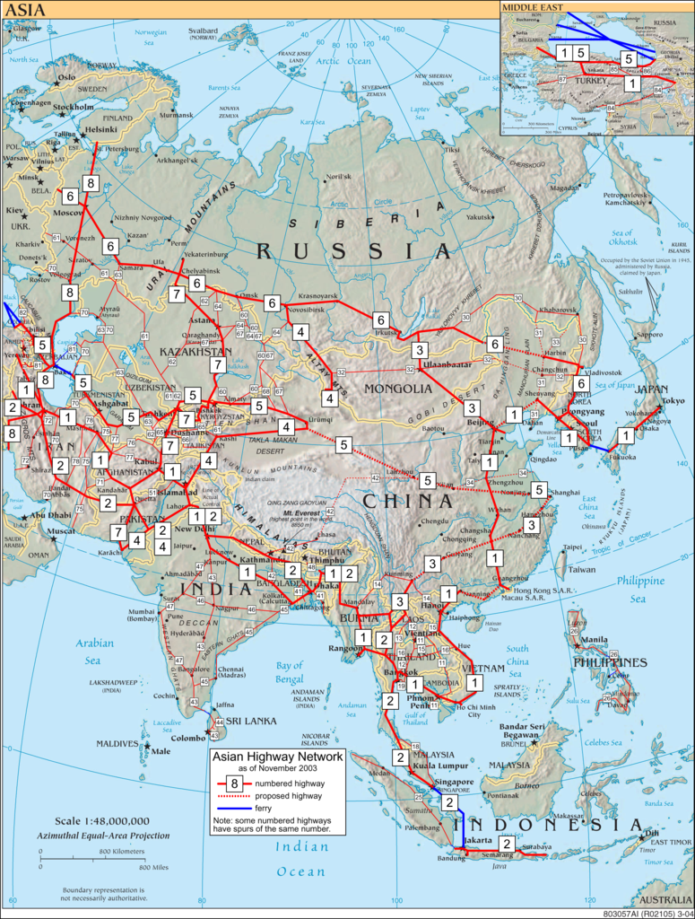
Asian Highway Network, drawn on a public domain CIA map.

|
This road map image could be re-created using vector graphics as an SVG file. This has several advantages; see Commons:Media for cleanup for more information. If an SVG form of this image is available, please upload it and afterwards replace this template with
{{vector version available|new image name}}.
It is recommended to name the SVG file “Asian Highways.svg”—then the template Vector version available (or Vva) does not need the new image name parameter. |
د دوتنې پېښليک
په يوې نېټې/يوه وخت وټوکۍ چې د هماغه وخت او نېټې دوتنه چې څنگه ښکارېده هماغسې درښکاره شي.
| نېټه/وخت | بټنوک | ډډې | کارن | تبصره | |
|---|---|---|---|---|---|
| اوسنی | ۱۰:۰۶, ۱۶ اپرېل ۲۰۰۵ | | ۲٬۰۲۶ × ۲٬۶۷۸ (۶٫۸۵ مېگابايټ) | SPUI~commonswiki | {{spuimap}} Asian Highway Network, drawn on a public domain CIA map. category:Asian Highway Networkcategory:road maps |
د دوتنې کارېدنه
دا 2 لانديني مخونه د همدې دوتنې سره تړنې لري:
د نړېوالې دوتنې کارېدنه
همدا دوتنه لاندينۍ نورې ويکي گانې کاروي:
- په bn.wikipedia.org کارونې
- په cs.wikipedia.org کارونې
- په de.wikipedia.org کارونې
- په de.wikiversity.org کارونې
- په en.wikipedia.org کارونې
- Asian Highway Network
- AH7
- Route 9 (Hong Kong)
- Controlled-access highway
- Trans-Sumatra Highway
- AH1
- Pan-Borneo Highway
- AH18
- Pan-Philippine Highway
- AH6 (highway)
- AH2
- National Highway 6 (India, old numbering)
- AH46
- AH45
- AH43
- AH47
- AH42
- National Highway 16 (India)
- Route 10 (Hong Kong)
- Mahendra Highway
- Template:Asian Highway Network
- AH3
- North Coast Road (Java)
- AH31
- Tribhuvan Highway
- G1011 Harbin–Tongjiang Expressway
- AH5
- AH12
- AH143
- AH4
- AH140
- AH141
- AH142
- AH8
- AH72
د دې دوتنې نورې نړېوالې کارېدنې کتل.