
دوتنه:The States of Austria Numbered.svg

Size of this PNG preview of this SVG file: ۵۱۲ × ۲۸۰ پېکسل. نورې ژورليدنې: ۳۲۰ × ۱۷۵ پېکسل | ۶۴۰ × ۳۵۰ پېکسل | ۱٬۰۲۴ × ۵۶۰ پېکسل | ۱٬۲۸۰ × ۷۰۰ پېکسل | ۲٬۵۶۰ × ۱٬۴۰۰ پېکسل.
اصلي دوتنه (SVG دوتنه، نومېنلي ۵۱۲ × ۲۸۰ پېکسل، د دوتنې کچه: ۶۸ کيلوبايټ)
لنډيز
| څرگندونه |
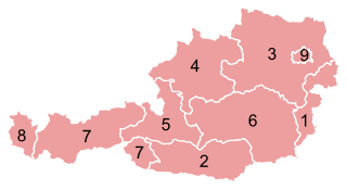
Deutsch: Karte der Bundesländer Österreichs.
English: Map of the States of Austria.
Français : Carte des Länder autrichiens.
Svenska: Karta över Österrikes förbundsländer. |
|||
| نېټه | ||||
| سرچينه |
This file was derived from: Karte A Wien.svg |
|||
| ليکوال |
Original: Vector: . |
|||
| اجازه (دا دوتنه بيا کارول) |
|
|||
| SVG genesis | This vector image was created with unknown tool.
|


د دوتنې پېښليک
په يوې نېټې/يوه وخت وټوکۍ چې د هماغه وخت او نېټې دوتنه چې څنگه ښکارېده هماغسې درښکاره شي.
| نېټه/وخت | بټنوک | ډډې | کارن | تبصره | |
|---|---|---|---|---|---|
| اوسنی | ۰۰:۴۱, ۲۵ ډيسمبر ۲۰۱۲ | | ۵۱۲ × ۲۸۰ (۶۸ کيلوبايټ) | GeMet | {{Information |Description = {{de|Karte der Bundesländer Österreichs.}} {{en|Map of the States of Austria.}} {{fr|Carte des Länder autrichiens.}} {{sv|Karta öve... |
د دوتنې کارېدنه
دا لاندينی مخ د همدې دوتنې سره تړنې لري:
د نړېوالې دوتنې کارېدنه
همدا دوتنه لاندينۍ نورې ويکي گانې کاروي:
- په ami.wikipedia.org کارونې
- په an.wikipedia.org کارونې
- په ar.wikipedia.org کارونې
- په azb.wikipedia.org کارونې
- په az.wikipedia.org کارونې
- په ba.wikipedia.org کارونې
- په be-tarask.wikipedia.org کارونې
- په be.wikipedia.org کارونې
- په bs.wikipedia.org کارونې
- په ca.wikipedia.org کارونې
- په cs.wikipedia.org کارونې
- په de.wikipedia.org کارونې
- په de.wikinews.org کارونې
- په el.wikipedia.org کارونې
- په eml.wikipedia.org کارونې
- په en.wikipedia.org کارونې
- په eo.wikipedia.org کارونې
- په es.wikipedia.org کارونې
- په et.wikipedia.org کارونې
- په eu.wikipedia.org کارونې
- په fa.wikipedia.org کارونې
- په frr.wikipedia.org کارونې
- په fr.wikipedia.org کارونې
- په gag.wikipedia.org کارونې
- په gd.wikipedia.org کارونې
- په gl.wikipedia.org کارونې
- په he.wikipedia.org کارونې
د دې دوتنې نورې نړېوالې کارېدنې کتل.