
دوتنه:Map-Lusophone World-en.png

د همدې ليدنې کچه: ۸۰۰ × ۳۷۰ پېکسل. نورې ژورليدنې: ۳۲۰ × ۱۴۸ پېکسل | ۶۴۰ × ۲۹۶ پېکسل | ۱٬۳۵۷ × ۶۲۸ پېکسل.
اصلي دوتنه (۱٬۳۵۷ × ۶۲۸ پېکسل, د دوتنې کچه: ۳۷ کيلوبايټ, MIME بڼه: image/png)
لنډيز
| څرگندونه |
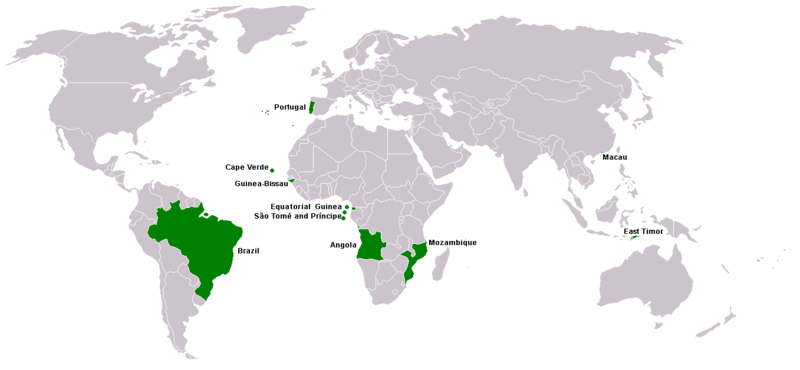
Map of Lusophone world. Map made from Image:BlankMap-World.png. The blank map was made by User:Vardion and adapted by User:E Pluribus Anthony for Wikipedia. |
||||
| نېټه | |||||
| سرچينه | شخصي اثر | ||||
| ليکوال | This version was made by User:Yug with country names by User:Sting. Fixed by User:The Ogre | ||||
| اجازه (دا دوتنه بيا کارول) |
|
||||
| نورې بڼې |
|


د دوتنې پېښليک
په يوې نېټې/يوه وخت وټوکۍ چې د هماغه وخت او نېټې دوتنه چې څنگه ښکارېده هماغسې درښکاره شي.
| نېټه/وخت | بټنوک | ډډې | کارن | تبصره | |
|---|---|---|---|---|---|
| اوسنی | ۲۱:۳۵, ۷ مارچ ۲۰۱۸ | | ۱٬۳۵۷ × ۶۲۸ (۳۷ کيلوبايټ) | Maphobbyist | South Sudan border |
| ۱۵:۱۳, ۲۱ اپرېل ۲۰۱۶ |  | ۱٬۳۵۷ × ۶۲۸ (۱۴ کيلوبايټ) | Avayak | optimized losslessly | |
| ۲۳:۰۹, ۲۲ فبروري ۲۰۰۸ |  | ۱٬۳۵۷ × ۶۲۸ (۴۷ کيلوبايټ) | The Ogre | New version, taken from the English wikipedia, where en:User:Domaleixo had done a new version of this map adding Equatorial Guinea, that also has Portuguese as official language. The license is "I, the copyright holder of this work, hereby release it | |
| ۰۳:۲۰, ۴ جون ۲۰۰۷ |  | ۱٬۳۵۷ × ۶۲۸ (۴۷ کيلوبايټ) | Hoshie | added Cabinda (Angola) and Montenegro. Same license. Put Cabinda in green as it is a part of Angola. | |
| ۱۶:۰۶, ۴ مې ۲۰۰۷ |  | ۱٬۳۵۷ × ۶۲۸ (۱۹ کيلوبايټ) | Tene~commonswiki | Optimised (0) | |
| ۱۴:۰۰, ۴ مې ۲۰۰۷ |  | ۱٬۳۵۷ × ۶۲۸ (۴۷ کيلوبايټ) | EugeneZelenko | Corrected version from Image:Map-Lusophone World-eng.png by User:The Ogre. Same license. | |
| ۱۸:۵۰, ۲۳ جنوري ۲۰۰۶ |  | ۱٬۳۵۷ × ۶۲۸ (۳۸ کيلوبايټ) | Sting | Map of Lusophone world. Map made from Image:BlankMap-World.png The blank map was made by User:Vardion and adapted by User:E Pluribus Anthony for Wikipedia. This version was made by User:Yug with country names by [[Us |
د دوتنې کارېدنه
داسې هېڅ کوم مخ نه شته چې د دغې دوتنې سره تړنې ولري.
د نړېوالې دوتنې کارېدنه
همدا دوتنه لاندينۍ نورې ويکي گانې کاروي:
- په da.wikipedia.org کارونې
- په de.wikipedia.org کارونې
- په en.wikipedia.org کارونې
- په fr.wikipedia.org کارونې
- په nl.wikipedia.org کارونې
- په nn.wikipedia.org کارونې
- په no.wikipedia.org کارونې
- په pt.wikinews.org کارونې
- په sv.wikipedia.org کارونې
- په zh.wikipedia.org کارونې