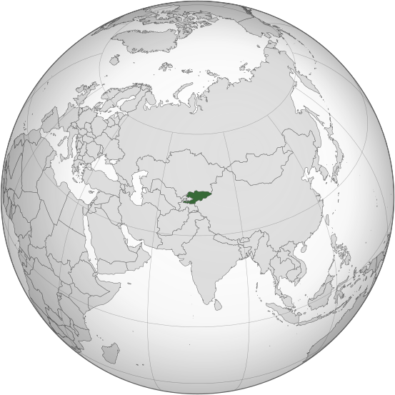
دوتنه:Kyrgyzstan (orthographic projection).svg

Size of this PNG preview of this SVG file: ۵۵۳ × ۵۵۳ پېکسل. نورې ژورليدنې: ۲۴۰ × ۲۴۰ پېکسل | ۴۸۰ × ۴۸۰ پېکسل | ۷۶۸ × ۷۶۸ پېکسل | ۱٬۰۲۴ × ۱٬۰۲۴ پېکسل | ۲٬۰۴۸ × ۲٬۰۴۸ پېکسل.
اصلي دوتنه (SVG دوتنه، نومېنلي ۵۵۳ × ۵۵۳ پېکسل، د دوتنې کچه: ۳۴۶ کيلوبايټ)
د دوتنې پېښليک
په يوې نېټې/يوه وخت وټوکۍ چې د هماغه وخت او نېټې دوتنه چې څنگه ښکارېده هماغسې درښکاره شي.
| نېټه/وخت | بټنوک | ډډې | کارن | تبصره | |
|---|---|---|---|---|---|
| اوسنی | ۰۱:۰۸, ۳۱ جولای ۲۰۲۳ |  | ۵۵۳ × ۵۵۳ (۳۴۶ کيلوبايټ) | Cutlass | rv sock edits |
| ۱۶:۰۹, ۶ جون ۲۰۲۳ |  | ۵۵۳ × ۵۵۳ (۳۱۰ کيلوبايټ) | Cutlerys | Reverted to version as of 12:34, 4 August 2013 (UTC) | |
| ۱۶:۰۸, ۶ جون ۲۰۲۳ |  | ۵۵۳ × ۵۵۳ (۳۰۶ کيلوبايټ) | Cutlerys | Reverted to version as of 23:39, 16 March 2015 (UTC) | |
| ۱۸:۱۷, ۱ مې ۲۰۱۶ |  | ۵۵۳ × ۵۵۳ (۳۴۶ کيلوبايټ) | Nicolay Sidorov | ... | |
| ۲۳:۳۹, ۱۶ مارچ ۲۰۱۵ |  | ۵۵۳ × ۵۵۳ (۳۰۶ کيلوبايټ) | Flappiefh | Removed Somaliland and Kosovo. Separated Western Sahara and Morroco. | |
| ۱۲:۳۴, ۴ اگسټ ۲۰۱۳ |  | ۵۵۳ × ۵۵۳ (۳۱۰ کيلوبايټ) | Flappiefh | Added South Sudan. The map is now centered on Kyrgyzstan. | |
| ۱۶:۰۲, ۹ جولای ۲۰۱۲ |  | ۵۵۰ × ۵۵۰ (۴۹۰ کيلوبايټ) | Hariboneagle927 |
د دوتنې کارېدنه
دا لاندينی مخ د همدې دوتنې سره تړنې لري:
د نړېوالې دوتنې کارېدنه
همدا دوتنه لاندينۍ نورې ويکي گانې کاروي:
- په ady.wikipedia.org کارونې
- په af.wikipedia.org کارونې
- په ami.wikipedia.org کارونې
- په ar.wikipedia.org کارونې
- په arz.wikipedia.org کارونې
- په ast.wikipedia.org کارونې
- په as.wikipedia.org کارونې
- په av.wikipedia.org کارونې
- په azb.wikipedia.org کارونې
- په bcl.wikipedia.org کارونې
- په bg.wikipedia.org کارونې
- په bh.wikipedia.org کارونې
- په bi.wikipedia.org کارونې
- په blk.wikipedia.org کارونې
- په bn.wikipedia.org کارونې
- په ca.wikipedia.org کارونې
- په cdo.wikipedia.org کارونې
- په ceb.wikipedia.org کارونې
- په cs.wikipedia.org کارونې
- په cy.wikipedia.org کارونې
- په dag.wikipedia.org کارونې
- په da.wikipedia.org کارونې
- په de.wikivoyage.org کارونې
- په diq.wikipedia.org کارونې
- په el.wikipedia.org کارونې
- په en.wikipedia.org کارونې
- په en.wikinews.org کارونې
- په eo.wikipedia.org کارونې
- په es.wikipedia.org کارونې
- په fa.wikipedia.org کارونې
- په fi.wikipedia.org کارونې
- په fo.wikipedia.org کارونې
- په frr.wikipedia.org کارونې
د دې دوتنې نورې نړېوالې کارېدنې کتل.

