
دوتنه:Konya districts.png

د همدې ليدنې کچه: ۷۳۷ × ۵۹۹ پېکسل. نورې ژورليدنې: ۲۹۵ × ۲۴۰ پېکسل | ۵۹۰ × ۴۸۰ پېکسل | ۹۵۸ × ۷۷۹ پېکسل.
اصلي دوتنه (۹۵۸ × ۷۷۹ پېکسل, د دوتنې کچه: ۵۶ کيلوبايټ, MIME بڼه: image/png)
لنډيز
Created by Rarelibra 22:01, 1 December 2006 (UTC) for public domain use, using MapInfo Professional v8.5 and various mapping resources. Edited by One Homo Sapiens Corrected text where İ,Ş,ı,ğ,or ş occurs in name. Source: [statoids-com]. Increased font size and enhanced color differences among adjacent districts.
| څرگندونه |
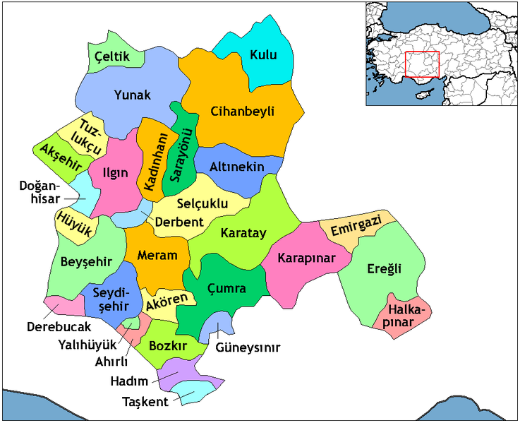
English: Map of the districts in the Province of Konya — in the Central Anatolia Region of Asian Turkey.
Svenska: Konya_Districts.png |
| نېټه | |
| سرچينه | Created by Rarelibra, edited by One Homo Sapiens |
| ليکوال | Rarelibra, One Homo Sapiens |
منښتليک:
| I, the copyright holder of this work, release this work into the public domain. This applies worldwide. In some countries this may not be legally possible; if so: I grant anyone the right to use this work for any purpose, without any conditions, unless such conditions are required by law. |
د دوتنې پېښليک
په يوې نېټې/يوه وخت وټوکۍ چې د هماغه وخت او نېټې دوتنه چې څنگه ښکارېده هماغسې درښکاره شي.
| نېټه/وخت | بټنوک | ډډې | کارن | تبصره | |
|---|---|---|---|---|---|
| اوسنی | ۲۱:۰۶, ۲۹ اکتوبر ۲۰۱۴ | | ۹۵۸ × ۷۷۹ (۵۶ کيلوبايټ) | Kimsaka | white frame cropped |
| ۱۰:۱۴, ۲۳ جون ۲۰۱۱ |  | ۱٬۰۵۶ × ۸۱۶ (۵۵ کيلوبايټ) | Yrytyr | Districts of Konya | |
| ۱۹:۰۰, ۸ فبروري ۲۰۱۱ |  | ۷۳۰ × ۶۰۰ (۲۲۲ کيلوبايټ) | Kurdische 1 | Districts Of Konya | |
| ۱۸:۵۰, ۸ فبروري ۲۰۱۱ |  | ۷۳۰ × ۶۰۰ (۲۲۰ کيلوبايټ) | Kurdische 1 | Districtrs Of Konya | |
| ۱۸:۰۸, ۸ فبروري ۲۰۱۱ |  | ۸۰۰ × ۶۰۰ (۲۷۰ کيلوبايټ) | Kurdische 1 | Districts Of Konya | |
| ۱۴:۴۳, ۵ فبروري ۲۰۱۱ |  | ۷۱۲ × ۵۸۳ (۲۲۱ کيلوبايټ) | Kurdische 1 | Districts_of_Konya.png | |
| ۱۴:۳۱, ۵ فبروري ۲۰۱۱ |  | ۹۶۰ × ۷۲۰ (۲۳۲ کيلوبايټ) | Kurdische 1 | Districts_of_Konya.png | |
| ۱۸:۰۳, ۲۰ جنوري ۲۰۱۱ |  | ۸۰۰ × ۶۰۰ (۱۶۲ کيلوبايټ) | Kurdische 1 | Konya_Turkey_Districts.png | |
| ۱۷:۴۶, ۲۰ جنوري ۲۰۱۱ |  | ۱٬۰۵۶ × ۸۱۶ (۴۶ کيلوبايټ) | Kurdische 1 | Reverted to version as of 22:01, 1 December 2006 | |
| ۰۱:۲۶, ۲۹ ډيسمبر ۲۰۰۸ |  | ۱٬۰۵۶ × ۸۱۶ (۵۵ کيلوبايټ) | One Homo Sapiens | Corrected text where İ,Ş,ı,ğ,or ş occurs in name. Source: [statoids-com]. Increased font size and enhanced color differences among adjacent districts. |
د دوتنې کارېدنه
دا لاندينی مخ د همدې دوتنې سره تړنې لري:
د نړېوالې دوتنې کارېدنه
همدا دوتنه لاندينۍ نورې ويکي گانې کاروي:
- په ar.wikipedia.org کارونې
- په ast.wikipedia.org کارونې
- په av.wikipedia.org کارونې
- په azb.wikipedia.org کارونې
- په ba.wikipedia.org کارونې
- په be.wikipedia.org کارونې
- په ca.wikipedia.org کارونې
- په ceb.wikipedia.org کارونې
- په ce.wikipedia.org کارونې
- په da.wikipedia.org کارونې
- په de.wikipedia.org کارونې
- Konya
- Ereğli (Konya)
- Konya (Provinz)
- Diskussion:Konya
- Akşehir
- Beyşehir
- Doğanhisar
- Kulu (Konya)
- Cihanbeyli
- Vorlage:Navigationsleiste Landkreise der Provinz Konya
- Ahırlı
- Akören
- Altınekin
- Bozkır
- Çeltik
- Çumra
- Derbent (Konya)
- Derebucak
- Emirgazi
- Güneysınır
- Hadim (Konya)
- Halkapınar
- Hüyük
- Ilgın
- Kadınhanı
- Karatay (Konya)
- Meram (Konya)
- Sarayönü
- Selçuklu
- Seydişehir
- Taşkent
- Tuzlukçu
د دې دوتنې نورې نړېوالې کارېدنې کتل.