
دوتنه:Khyber Pakhtunkhwa Districts.svg

Size of this PNG preview of this SVG file: ۳۸۶ × ۵۹۹ پېکسل. نورې ژورليدنې: ۱۵۴ × ۲۴۰ پېکسل | ۳۰۹ × ۴۸۰ پېکسل | ۴۹۴ × ۷۶۸ پېکسل | ۶۵۹ × ۱٬۰۲۴ پېکسل | ۱٬۳۱۹ × ۲٬۰۴۸ پېکسل | ۶۴۴ × ۱٬۰۰۰ پېکسل.
اصلي دوتنه (SVG دوتنه، نومېنلي ۶۴۴ × ۱٬۰۰۰ پېکسل، د دوتنې کچه: ۸۷ کيلوبايټ)
لنډيز
| څرگندونه |
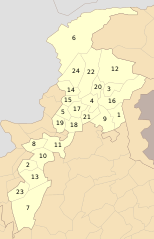
English: The up shown map is of October 2014. It contains only 24 districts and it doesn't contain a new District Torghar. The new map which include 25 districts and created in December 2014 was available here: Khyber Pakhtunkhwa Districts 2014.png |
| نېټه | |
| سرچينه | شخصي اثر |
| ليکوال | Schajee |
| SVG genesis |
منښتليک:
| I, the copyright holder of this work, release this work into the public domain. This applies worldwide. In some countries this may not be legally possible; if so: I grant anyone the right to use this work for any purpose, without any conditions, unless such conditions are required by law. |
د دوتنې پېښليک
په يوې نېټې/يوه وخت وټوکۍ چې د هماغه وخت او نېټې دوتنه چې څنگه ښکارېده هماغسې درښکاره شي.
| نېټه/وخت | بټنوک | ډډې | کارن | تبصره | |
|---|---|---|---|---|---|
| اوسنی | ۲۳:۲۸, ۱۹ نومبر ۲۰۱۹ | | ۶۴۴ × ۱٬۰۰۰ (۸۷ کيلوبايټ) | আফতাবুজ্জামান | File uploaded using svgtranslate tool (https://tools.wmflabs.org/svgtranslate/). Added translation for bn. |
| ۱۴:۰۴, ۳۱ جولای ۲۰۱۶ |  | ۶۴۴ × ۱٬۰۰۰ (۵۶ کيلوبايټ) | Furfur | enlarged the numbers, such that they can be read in the preview | |
| ۱۴:۳۱, ۲۰ جنوري ۲۰۱۵ |  | ۶۴۴ × ۱٬۰۰۰ (۶۲ کيلوبايټ) | Ciaurlec | Reverted to version as of 21:15, 10 October 2010 | |
| ۰۳:۱۴, ۳ ډيسمبر ۲۰۱۴ |  | ۸۰۰ × ۱٬۲۴۳ (۵۲۱ بايټ) | UsmanKhan | Included the new District "Torghar". | |
| ۲۱:۱۵, ۱۰ اکتوبر ۲۰۱۰ |  | ۶۴۴ × ۱٬۰۰۰ (۶۲ کيلوبايټ) | Schajee | {{Information |Description={{en|1=Districts of Khyber Pakhtunkhwa as of Oct 2010}} |Source={{own}} |Author=Schajee |Date=2010-10-10 |Permission= |other_versions= }} Category:Maps of Pakistan |
د دوتنې کارېدنه
دا 4 لانديني مخونه د همدې دوتنې سره تړنې لري:
د نړېوالې دوتنې کارېدنه
همدا دوتنه لاندينۍ نورې ويکي گانې کاروي:
- په bn.wikipedia.org کارونې
- সোয়াত জেলা
- টেমপ্লেট:খাইবার পাখতুনখোয়ার জেলা
- মালাকান্দ জেলা
- হরিপুর জেলা
- পেশাওয়ার জেলা
- বান্নু জেলা
- লাক্কি মারওয়াত জেলা
- ডেরা ইসমাইল খান জেলা
- উত্তর ওয়াজিরিস্তান
- দক্ষিণ ওয়াজিরিস্তান
- ট্যাঙ্ক জেলা
- অ্যাবোটাবাদ জেলা
- বট্টগ্রাম জেলা
- কলাই-পলাস জেলা
- নিম্ন কোহিস্তান জেলা
- মনসেহরা জেলা
- তরঘার জেলা
- উচ্চ কোহিস্তান জেলা
- হঙ্গু জেলা
- কারাক জেলা
- কোহাত জেলা
- কুররাম জেলা
- ওরাকজাই জেলা
- বাজৌর জেলা
- বুনের জেলা
- চিত্রাল জেলা
- নিম্ন দির জেলা
- শাংলা জেলা
- উচ্চ দির জেলা
- মর্দান জেলা
- সোয়াবি জেলা
- চরসাদ্দা জেলা (পাকিস্তান)
- খাইবার জেলা
- মোহমান্দ জেলা
- নওশেরা জেলা
- খাইবার পাখতুনখোয়ার জেলার তালিকা
- په en.wikipedia.org کارونې
- په fa.wikipedia.org کارونې
د دې دوتنې نورې نړېوالې کارېدنې کتل.