
دوتنه:Kenya topographic map-fr.svg

Size of this PNG preview of this SVG file: ۵۷۵ × ۵۹۹ پېکسل. نورې ژورليدنې: ۲۳۰ × ۲۴۰ پېکسل | ۴۶۰ × ۴۸۰ پېکسل | ۷۳۷ × ۷۶۸ پېکسل | ۹۸۲ × ۱٬۰۲۴ پېکسل | ۱٬۹۶۵ × ۲٬۰۴۸ پېکسل | ۱٬۱۸۱ × ۱٬۲۳۱ پېکسل.
اصلي دوتنه (SVG دوتنه، نومېنلي ۱٬۱۸۱ × ۱٬۲۳۱ پېکسل، د دوتنې کچه: ۳٫۲۶ مېگابايټ)
لنډيز
| څرگندونه |
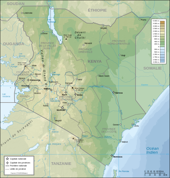
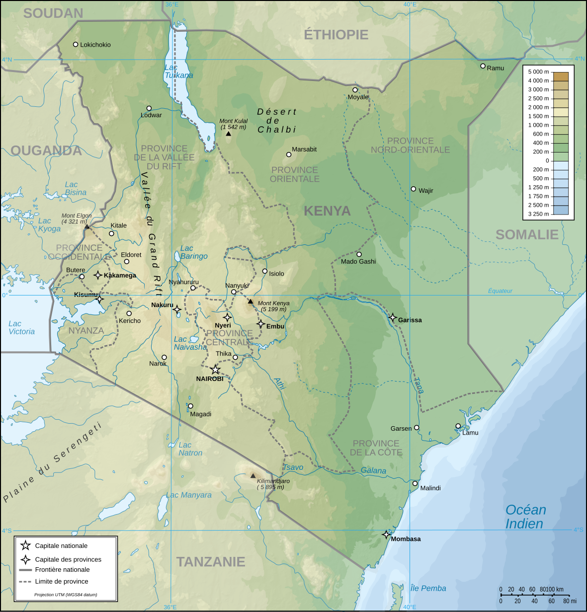
Français : Carte topographique du Kenya. Version française
English: Topographic map in French of Kenya |
| نېټه | |
| سرچينه |
شخصي اثر (Original text: Own Work made with Inkscape From Topographic map : NASA Shuttle Radar Topography Mission (SRTM3 v.2) (public domain) edited with Global Mapper 9 from Visualization Software LLC and vectorized with Inkscape ; UTM projection ; WGS84 datum ; shaded relief (composite image of N-W, W and N lightning positions) ; Rivers, borders, cities : Demis add-on for World Wind ; Other references used : * NASA World Wind ; * File:Kenya-relief-map-towns.jpg ; Notes : The shaded relief is a raster image embedded in the SVG file which increases its size. If you want a lighter map for other purposes, delete the shaded relief image in your file.) |
| ليکوال | Pinpin |
| نورې بڼې |
Derivative works of this file: |
| SVG genesis |

| Camera location | | View this and other nearby images on: OpenStreetMap |
|---|
منښتليک:
I, the copyright holder of this work, hereby publish it under the following licenses:
| Copyleft: This work of art is free; you can redistribute it and/or modify it according to terms of the Free Art License. You will find a specimen of this license on the Copyleft Attitude site as well as on other sites. |
This file is licensed under the Creative Commons Attribution-Share Alike 4.0 International, 3.0 Unported, 2.5 Generic, 2.0 Generic and 1.0 Generic license.
- تاسې کولی شئ چې:
- بيا يې د نورو سره شريک کړئ – همدا اثر ولمېسئ، و وېشئ او بيا يې خپور کړئ
- بيا ادلون بدلون راولئ – بدل شوی اثر خپل کړئ
- د لاندې شرطونو له مخې:
- اړوندېدنه – تاسې بايد دا اثر د ليکوال يا منښتگر لخوا د ځانگړو شويو اصولو سره اړونده وگڼئ (خو په دې توگه نه چې داسې ښکاره شي چې گنې تاسې يا ستاسې لخوا کارېدنه د اثر د ملاتړ سبب شوی)
- يوشان شريکول – که تاسې همدا اثر بدلوئ، رغوئ، او يا يې هم سر له نوي جوړوئ نو په پايله کې رامېنځ ته شوی اثر به يوازې د همدې دوتنې ورته منښتليک پر بنسټ خپروئ.
تاسې د خپلې خوښې منښتليک ټاکلی شی.
| Annotations | This image is annotated: View the annotations at Commons |
د دوتنې پېښليک
په يوې نېټې/يوه وخت وټوکۍ چې د هماغه وخت او نېټې دوتنه چې څنگه ښکارېده هماغسې درښکاره شي.
| نېټه/وخت | بټنوک | ډډې | کارن | تبصره | |
|---|---|---|---|---|---|
| اوسنی | ۱۹:۴۸, ۱۴ اگسټ ۲۰۲۳ | | ۱٬۱۸۱ × ۱٬۲۳۱ (۳٫۲۶ مېگابايټ) | Sémhur | Correction des latitudes et longitudes |
| ۱۰:۰۰, ۳۰ اپرېل ۲۰۰۸ |  | ۱٬۱۸۱ × ۱٬۲۳۱ (۳٫۲۸ مېگابايټ) | Sémhur | Orthograph : provence => province | |
| ۱۹:۴۸, ۷ اپرېل ۲۰۰۸ |  | ۱٬۱۸۱ × ۱٬۲۳۱ (۳٫۲۸ مېگابايټ) | Pinpin | == Description == {{Information |Description={{fr|Carte topographique du Kenya. Version française}} {{en|Topographic map in French of Kenya}} |Source=Own Work made with Inkscape From <br/>Topographic map : [http://www2.jpl.nasa.gov/srtm NASA Shuttle Rada |
د دوتنې کارېدنه
دا لاندينی مخ د همدې دوتنې سره تړنې لري:
د نړېوالې دوتنې کارېدنه
همدا دوتنه لاندينۍ نورې ويکي گانې کاروي:
- په avk.wikipedia.org کارونې
- په ca.wikipedia.org کارونې
- په de.wikipedia.org کارونې
- په en.wikipedia.org کارونې
- په es.wikipedia.org کارونې
- په fr.wikipedia.org کارونې
- په nl.wikipedia.org کارونې
- په ru.wikipedia.org کارونې
- په uk.wikipedia.org کارونې