
دوتنه:FATA Districts.svg

Size of this PNG preview of this SVG file: ۳۷۱ × ۵۹۹ پېکسل. نورې ژورليدنې: ۱۴۸ × ۲۴۰ پېکسل | ۲۹۷ × ۴۸۰ پېکسل | ۴۷۵ × ۷۶۸ پېکسل | ۶۳۴ × ۱٬۰۲۴ پېکسل | ۱٬۲۶۸ × ۲٬۰۴۸ پېکسل | ۶۱۹ × ۱٬۰۰۰ پېکسل.
اصلي دوتنه (SVG دوتنه، نومېنلي ۶۱۹ × ۱٬۰۰۰ پېکسل، د دوتنې کچه: ۳۱ کيلوبايټ)
لنډيز
| څرگندونه |
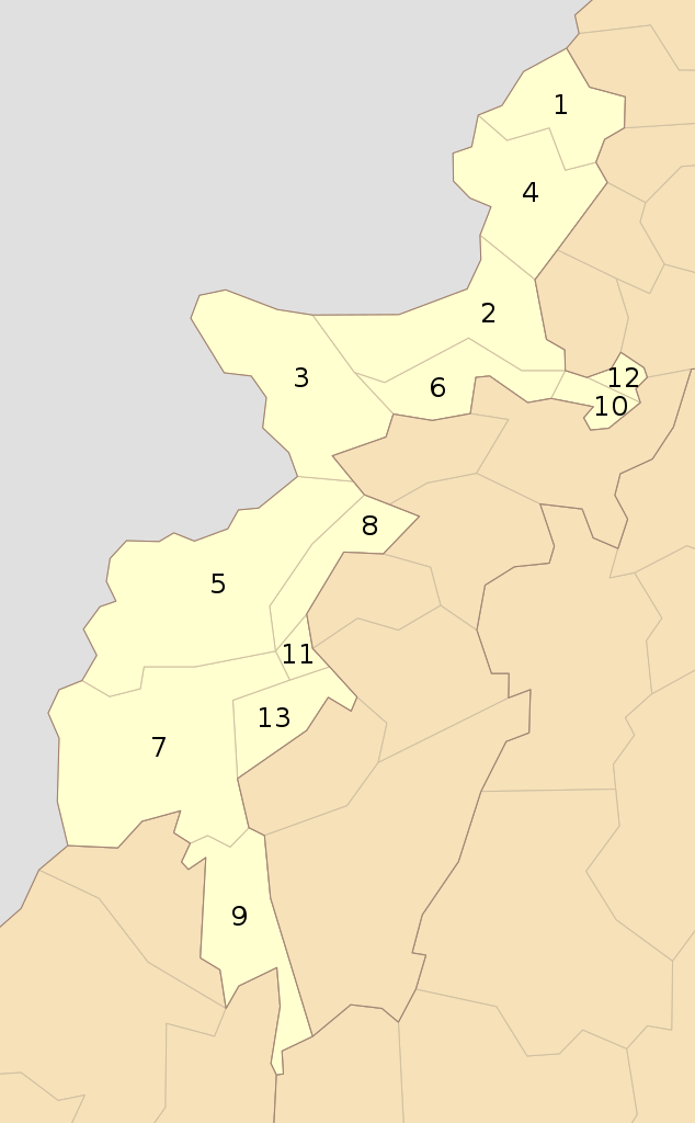
English: Districts of Federally Administered Tribal Areas and Frontier Regions as of Oct 2010 |
| نېټه | |
| سرچينه | شخصي اثر |
| ليکوال | Schajee |
| SVG genesis |
منښتليک:
| I, the copyright holder of this work, release this work into the public domain. This applies worldwide. In some countries this may not be legally possible; if so: I grant anyone the right to use this work for any purpose, without any conditions, unless such conditions are required by law. |
د دوتنې پېښليک
په يوې نېټې/يوه وخت وټوکۍ چې د هماغه وخت او نېټې دوتنه چې څنگه ښکارېده هماغسې درښکاره شي.
| نېټه/وخت | بټنوک | ډډې | کارن | تبصره | |
|---|---|---|---|---|---|
| اوسنی | ۱۴:۰۴, ۳۱ جولای ۲۰۱۶ | | ۶۱۹ × ۱٬۰۰۰ (۳۱ کيلوبايټ) | Furfur | enlarged the numbers, such that they can be read in the preview |
| ۰۶:۱۷, ۱۱ اکتوبر ۲۰۱۰ |  | ۶۱۹ × ۱٬۰۰۰ (۳۴ کيلوبايټ) | Schajee | {{Information |Description={{en|1=Districts of Federally Administered Tribal Areas and Frontier Regions as of Oct 2010}} |Source={{own}} |Author=Schajee |Date= |Permission= |other_versions= }} Category:Maps of Pakistan |
د دوتنې کارېدنه
دا لاندينی مخ د همدې دوتنې سره تړنې لري:
د نړېوالې دوتنې کارېدنه
همدا دوتنه لاندينۍ نورې ويکي گانې کاروي:
- په ms.wikipedia.org کارونې
- په pt.wikipedia.org کارونې
- په ru.wikipedia.org کارونې
- په simple.wikipedia.org کارونې