
دوتنه:Black Americans by county.png

د همدې ليدنې کچه: ۸۰۰ × ۴۲۷ پېکسل. نورې ژورليدنې: ۳۲۰ × ۱۷۱ پېکسل | ۶۴۰ × ۳۴۱ پېکسل | ۱٬۰۲۴ × ۵۴۶ پېکسل | ۱٬۲۸۰ × ۶۸۳ پېکسل | ۲٬۵۶۰ × ۱٬۳۶۵ پېکسل | ۷٬۵۰۰ × ۴٬۰۰۰ پېکسل.
اصلي دوتنه (۷٬۵۰۰ × ۴٬۰۰۰ پېکسل, د دوتنې کچه: ۴٫۴۱ مېگابايټ, MIME بڼه: image/png)

|
This map image could be re-created using vector graphics as an SVG file. This has several advantages; see Commons:Media for cleanup for more information. If an SVG form of this image is available, please upload it and afterwards replace this template with
{{vector version available|new image name}}.
It is recommended to name the SVG file “Black Americans by county.svg”—then the template Vector version available (or Vva) does not need the new image name parameter. |
لنډيز
| څرگندونه |
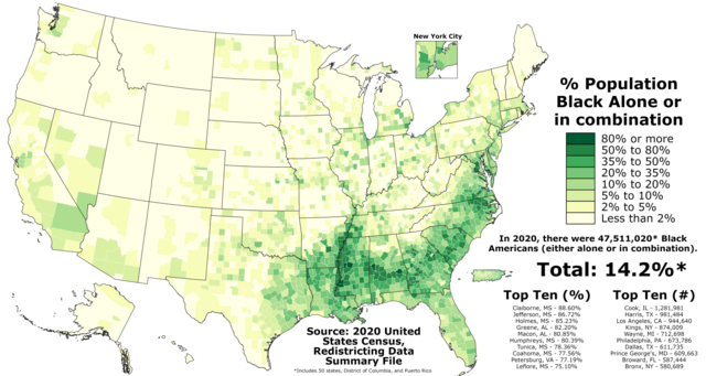
English: The map above shows the proportion of Black Americans (alone or in combination) in each county in the fifty states, the District of Columbia, and Puerto Rico according to the official results of the 2020 United States Census. The data can be found here.
This file should next be updated when the 2021 Vintage Racial and Ethnic Population Estimates are released on the county level, currently expected to occur in June 2022. |
| نېټه | |
| سرچينه | شخصي اثر |
| ليکوال | Abbasi786786 |
منښتليک:
زه، د دې اثر د خپرولو او لمېسلو خاوند، دا دوتنه د لاندې منښتليک پر بنسټ دلته خپروم:
This file is licensed under the Creative Commons Attribution-Share Alike 4.0 International license.
- تاسې کولی شئ چې:
- بيا يې د نورو سره شريک کړئ – همدا اثر ولمېسئ، و وېشئ او بيا يې خپور کړئ
- بيا ادلون بدلون راولئ – بدل شوی اثر خپل کړئ
- د لاندې شرطونو له مخې:
- اړوندېدنه – تاسې بايد دا اثر د ليکوال يا منښتگر لخوا د ځانگړو شويو اصولو سره اړونده وگڼئ (خو په دې توگه نه چې داسې ښکاره شي چې گنې تاسې يا ستاسې لخوا کارېدنه د اثر د ملاتړ سبب شوی)
- يوشان شريکول – که تاسې همدا اثر بدلوئ، رغوئ، او يا يې هم سر له نوي جوړوئ نو په پايله کې رامېنځ ته شوی اثر به يوازې د همدې دوتنې ورته منښتليک پر بنسټ خپروئ.
د دوتنې پېښليک
په يوې نېټې/يوه وخت وټوکۍ چې د هماغه وخت او نېټې دوتنه چې څنگه ښکارېده هماغسې درښکاره شي.
| نېټه/وخت | بټنوک | ډډې | کارن | تبصره | |
|---|---|---|---|---|---|
| اوسنی | ۲۲:۰۹, ۶ ډيسمبر ۲۰۲۱ | | ۷٬۵۰۰ × ۴٬۰۰۰ (۴٫۴۱ مېگابايټ) | Abbasi786786 | Uploaded own work with UploadWizard |
د دوتنې کارېدنه
دا لاندينی مخ د همدې دوتنې سره تړنې لري:
د نړېوالې دوتنې کارېدنه
همدا دوتنه لاندينۍ نورې ويکي گانې کاروي:
- په ckb.wikipedia.org کارونې
- په de.wikipedia.org کارونې
- په el.wikipedia.org کارونې
- په en.wikipedia.org کارونې
- په en.wikiquote.org کارونې
- په es.wikipedia.org کارونې
- په et.wikipedia.org کارونې
- په fi.wikipedia.org کارونې
- په gl.wikipedia.org کارونې
- په he.wikipedia.org کارونې
- په hu.wikipedia.org کارونې
- په id.wikipedia.org کارونې
- په io.wikipedia.org کارونې
- په ko.wikipedia.org کارونې
- په ku.wikipedia.org کارونې
- په lv.wikipedia.org کارونې
- په pl.wikipedia.org کارونې