
دوتنه:1864 Johnson's Map of India (Hindostan or British India) - Geographicus - India-j-64.jpg

اصلي دوتنه (۲٬۵۰۰ × ۱٬۹۹۰ پېکسل, د دوتنې کچه: ۱٫۶۳ مېگابايټ, MIME بڼه: image/jpeg)
_-_Geographicus_-_India-j-64.jpg)
| Alvin Jewett Johnson: Johnson’s Hindostan or British India.
( |
|||||||||||||||||||||||
|---|---|---|---|---|---|---|---|---|---|---|---|---|---|---|---|---|---|---|---|---|---|---|---|
| هنرمند |
|
||||||||||||||||||||||
| لقب |
Johnson’s Hindostan or British India. |
||||||||||||||||||||||
| څرگندونه |
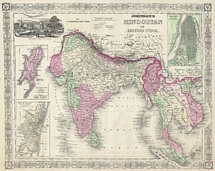
English: A very nice example of A. J. Johnson’s 1864 map of India and Southeast Asia. Covers from the Indus River eastward to include all of India, Burma, Siam (Thailand), Laos, Cambodia, Malaysia (Malacca) and Vietnam (Tonquin and Chochin). Also includes parts of Pakistan, Nepal, China, Bhutan, Sumatra and Ceylon (Sri Lanka). Offers color coding according to country and region as well as notations regarding roadways, cities, towns, and river systems. Three inset maps focus on the Island of Bombay (Mumbai), Madras, and Calcutta. An view of the Government House and Treasury in Calcutta adorns the upper left corner. Features the fretwork style border common to Johnson’s atlas work from 1864 to 1869. Published by A. J. Johnson and Ward as plate number 95 in the 1864 edition of Johnson’s New Illustrated Family Atlas. This is the last edition of the Johnson Atlas to bear the Johnson and Ward imprint, subsequent editions were attributed to Johnson exclusively. |
||||||||||||||||||||||
| نېټه | ۱۸۶۴ (undated) | ||||||||||||||||||||||
| Dimensions | height: ۱۳٫۰ in (۳۳٫۰ cm); width: ۱۷٫۰ in (۴۳٫۱ cm) | ||||||||||||||||||||||
| Accession number |
Geographicus link: India-j-64 |
||||||||||||||||||||||
| سرچينه/انځورگر |
Johnson, A. J., Johnson's New Illustrated Family Atlas of The World with Physical Geography, and with Descriptions Geographical, Statistical, and Historic including The Latest Federal Census, A Geographical Index, and a Chronological History of the Civil War in America, 1864.
|
||||||||||||||||||||||
| اجازه (دا دوتنه بيا کارول) |
|
||||||||||||||||||||||
د دوتنې پېښليک
په يوې نېټې/يوه وخت وټوکۍ چې د هماغه وخت او نېټې دوتنه چې څنگه ښکارېده هماغسې درښکاره شي.
| نېټه/وخت | بټنوک | ډډې | کارن | تبصره | |
|---|---|---|---|---|---|
| اوسنی | ۰۹:۴۴, ۱۶ مارچ ۲۰۱۱ | | ۲٬۵۰۰ × ۱٬۹۹۰ (۱٫۶۳ مېگابايټ) | BotMultichill | {{subst:User:Multichill/Geographicus |link=http://www.geographicus.com/P/AntiqueMap/India-j-64 |product_name=1864 Johnson's Map of India (Hindostan or British India) |map_title=Johnson’s Hindostan or British India. |description=A very nice example of A. |
د دوتنې کارېدنه
دا لاندينی مخ د همدې دوتنې سره تړنې لري:
د نړېوالې دوتنې کارېدنه
همدا دوتنه لاندينۍ نورې ويکي گانې کاروي:
- په ar.wikipedia.org کارونې
- په azb.wikipedia.org کارونې
- په en.wikipedia.org کارونې
- په fa.wikipedia.org کارونې
- په incubator.wikimedia.org کارونې
- په it.wikipedia.org کارونې
- په ml.wikipedia.org کارونې
- په nl.wikipedia.org کارونې
- په ru.wiktionary.org کارونې
- په sd.wikipedia.org کارونې
- په skr.wikipedia.org کارونې
- په sr.wikipedia.org کارونې
- په ta.wikipedia.org کارونې
- په th.wikipedia.org کارونې
- په ur.wikipedia.org کارونې
- په zh.wikipedia.org کارونې
_-_Geographicus_-_India-j-64.jpg)