
دوتنه:Mapa Myotis daubentonii.png

د همدې ليدنې کچه: ۸۰۰ × ۳۵۱ پېکسل. نورې ژورليدنې: ۳۲۰ × ۱۴۰ پېکسل | ۶۴۰ × ۲۸۱ پېکسل | ۱٬۴۲۵ × ۶۲۵ پېکسل.
اصلي دوتنه (۱٬۴۲۵ × ۶۲۵ پېکسل, د دوتنې کچه: ۵۰ کيلوبايټ, MIME بڼه: image/png)
لنډيز
| څرگندونه |
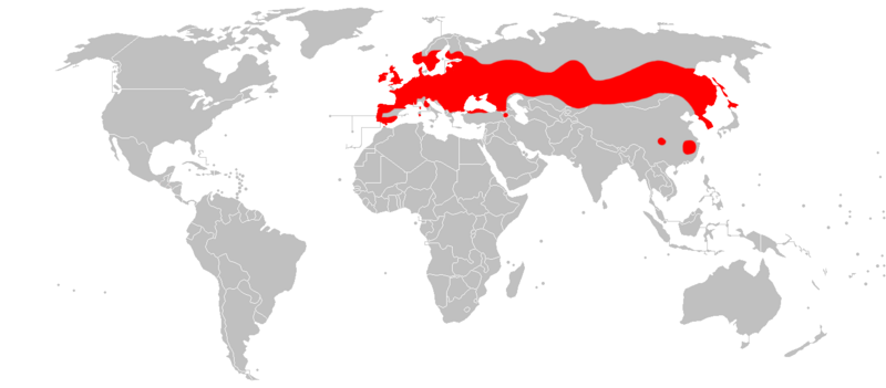
English: Distribution map of Myotis daubentonii.
Español: Mapa de distribución del murciélago de ribera (Myotis daubentonii). |
| نېټه | |
| سرچينه | شخصي اثر |
| ليکوال | Osado |
Data source:IUCN
منښتليک:
| I, the copyright holder of this work, release this work into the public domain. This applies worldwide. In some countries this may not be legally possible; if so: I grant anyone the right to use this work for any purpose, without any conditions, unless such conditions are required by law. |
د دوتنې پېښليک
په يوې نېټې/يوه وخت وټوکۍ چې د هماغه وخت او نېټې دوتنه چې څنگه ښکارېده هماغسې درښکاره شي.
| نېټه/وخت | بټنوک | ډډې | کارن | تبصره | |
|---|---|---|---|---|---|
| اوسنی | ۱۹:۴۰, ۲۱ مارچ ۲۰۱۸ | | ۱٬۴۲۵ × ۶۲۵ (۵۰ کيلوبايټ) | Maphobbyist | South Sudan border |
| ۱۶:۱۳, ۱۰ فبروري ۲۰۱۰ |  | ۱٬۴۲۵ × ۶۲۵ (۵۰ کيلوبايټ) | Osado | {{Information |Description={{en|1=Distribution map of ''Myotis daubentonii''.}} {{es|1=Mapa de distribución del murciélago de ribera (''Myotis daubentonii'').}} |Source={{own}} |Author=Osado |Date=2010 |Permission= |other_versions= }} Dat |
د دوتنې کارېدنه
دا لاندينی مخ د همدې دوتنې سره تړنې لري:
د نړېوالې دوتنې کارېدنه
همدا دوتنه لاندينۍ نورې ويکي گانې کاروي:
- په an.wikipedia.org کارونې
- په avk.wikipedia.org کارونې
- په be.wikipedia.org کارونې
- په bg.wikipedia.org کارونې
- په ca.wikipedia.org کارونې
- په ceb.wikipedia.org کارونې
- په cs.wikipedia.org کارونې
- په da.wikipedia.org کارونې
- په de.wikipedia.org کارونې
- په en.wikipedia.org کارونې
- په es.wikipedia.org کارونې
- په et.wikipedia.org کارونې
- په eu.wikipedia.org کارونې
- په fi.wikipedia.org کارونې
- په fr.wikipedia.org کارونې
- Liste des mammifères en France métropolitaine
- Liste des mammifères en Belgique
- Liste des mammifères en Espagne
- Liste des mammifères en Suisse
- Liste des mammifères au Luxembourg
- Liste des mammifères au Portugal continental
- Liste des mammifères en Italie
- Liste des mammifères en Allemagne
- Liste des mammifères au Royaume-Uni
- Liste des mammifères aux Pays-Bas européens
- Liste des mammifères en Roumanie
- Liste des mammifères en Norvège
- Liste des mammifères en Grèce
- Liste des mammifères en Autriche
- Liste des mammifères en Pologne
- Liste des mammifères en Andorre
- Liste des mammifères au Danemark
- Liste des mammifères en Irlande
- Liste des mammifères en Suède
- Liste des mammifères en Tchéquie
- Liste des mammifères en Finlande
- Liste des mammifères en Croatie
- Liste des mammifères en Hongrie
- Liste des mammifères en Ukraine
د دې دوتنې نورې نړېوالې کارېدنې کتل.