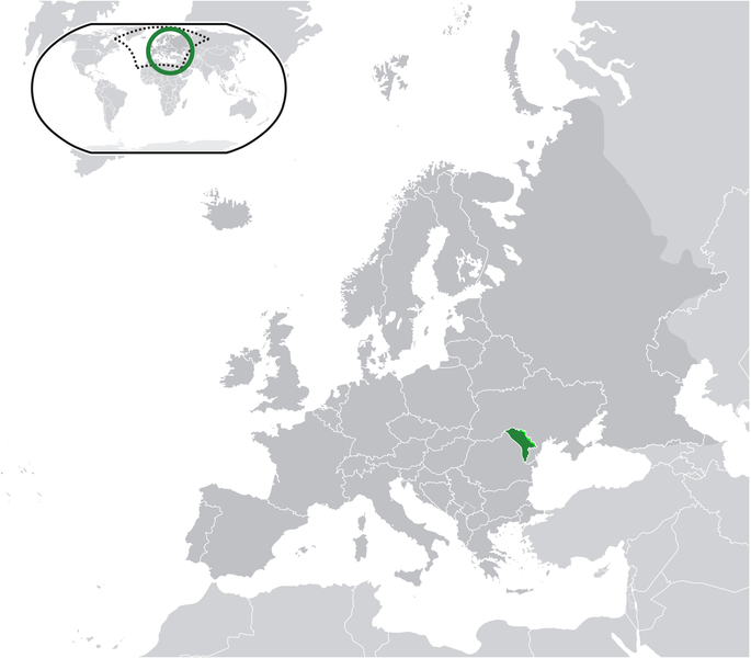
دوتنه:Location Moldova Europe.png

د همدې ليدنې کچه: ۶۸۵ × ۶۰۰ پېکسل. نورې ژورليدنې: ۲۷۴ × ۲۴۰ پېکسل | ۵۴۸ × ۴۸۰ پېکسل | ۸۷۷ × ۷۶۸ پېکسل | ۱٬۱۷۰ × ۱٬۰۲۴ پېکسل | ۲٬۰۵۶ × ۱٬۸۰۰ پېکسل.
اصلي دوتنه (۲٬۰۵۶ × ۱٬۸۰۰ پېکسل, د دوتنې کچه: ۴۲۲ کيلوبايټ, MIME بڼه: image/png)
د دوتنې پېښليک
په يوې نېټې/يوه وخت وټوکۍ چې د هماغه وخت او نېټې دوتنه چې څنگه ښکارېده هماغسې درښکاره شي.
| نېټه/وخت | بټنوک | ډډې | کارن | تبصره | |
|---|---|---|---|---|---|
| اوسنی | ۰۹:۵۸, ۲۲ مې ۲۰۲۱ |  | ۲٬۰۵۶ × ۱٬۸۰۰ (۴۲۲ کيلوبايټ) | Lupishor | Reverted to version as of 23:13, 11 July 2020 (UTC) Map is wrong, showing a part of Ukraine as part of Moldova |
| ۱۸:۱۰, ۱۹ مې ۲۰۲۱ |  | ۲٬۰۵۶ × ۱٬۸۰۰ (۳۲۷ کيلوبايټ) | Yesua Rafael Jara Alcivar | Reverted to version as of 01:27, 19 May 2021 (UTC) | |
| ۰۱:۲۷, ۱۹ مې ۲۰۲۱ |  | ۲٬۰۵۶ × ۱٬۸۰۰ (۴۲۶ کيلوبايټ) | Yesua Rafael Jara Alcivar | Reverted to version as of 01:20, 19 May 2021 (UTC) | |
| ۰۱:۲۷, ۱۹ مې ۲۰۲۱ |  | ۲٬۰۵۶ × ۱٬۸۰۰ (۳۲۷ کيلوبايټ) | Yesua Rafael Jara Alcivar | Agregando sus verdaderos territorios | |
| ۰۱:۲۰, ۱۹ مې ۲۰۲۱ |  | ۲٬۰۵۶ × ۱٬۸۰۰ (۴۲۶ کيلوبايټ) | Yesua Rafael Jara Alcivar | Añadiendo territorios que le pertenecen | |
| ۲۳:۱۳, ۱۱ جولای ۲۰۲۰ |  | ۲٬۰۵۶ × ۱٬۸۰۰ (۴۲۲ کيلوبايټ) | De728631 | added South Sudan to World map | |
| ۱۵:۵۷, ۲۲ فبروري ۲۰۱۰ |  | ۲٬۰۵۶ × ۱٬۸۰۰ (۳۵۵ کيلوبايټ) | Dinamik | colors | |
| ۲۳:۳۴, ۱۷ جون ۲۰۰۹ |  | ۲٬۰۵۶ × ۱٬۸۰۰ (۳۶۵ کيلوبايټ) | Bosonic dressing | {{Information |Description={{en|1=Moldova (green) / Transnistria (light green) / Europe (all green & dark grey); inspired by and consistent with general country locator maps by User:Vardion, et al}} |Source=Own work by uploader |Author=[[User:Bosonic dres |
د دوتنې کارېدنه
دا لاندينی مخ د همدې دوتنې سره تړنې لري:
د نړېوالې دوتنې کارېدنه
همدا دوتنه لاندينۍ نورې ويکي گانې کاروي:
- په af.wikipedia.org کارونې
- په af.wiktionary.org کارونې
- په ami.wikipedia.org کارونې
- په an.wikipedia.org کارونې
- په ar.wikipedia.org کارونې
- په ary.wikipedia.org کارونې
- په arz.wikipedia.org کارونې
- په ast.wikipedia.org کارونې
- په avk.wikipedia.org کارونې
- په awa.wikipedia.org کارونې
- په azb.wikipedia.org کارونې
- په az.wikipedia.org کارونې
- په az.wiktionary.org کارونې
- په ban.wikipedia.org کارونې
- په ba.wikipedia.org کارونې
- په be-tarask.wikipedia.org کارونې
- په be.wikipedia.org کارونې
- په bh.wikipedia.org کارونې
- په bi.wikipedia.org کارونې
- په bn.wikipedia.org کارونې
- په bo.wikipedia.org کارونې
- په bs.wikipedia.org کارونې
- په bxr.wikipedia.org کارونې
- په ca.wikipedia.org کارونې
- په cbk-zam.wikipedia.org کارونې
- په ce.wikipedia.org کارونې
- په chr.wikipedia.org کارونې
- په ckb.wikipedia.org کارونې
- په csb.wikipedia.org کارونې
- په cs.wikipedia.org کارونې
- په cv.wikipedia.org کارونې
- په cy.wikipedia.org کارونې
- په de.wikipedia.org کارونې
- په diq.wikipedia.org کارونې
- په dty.wikipedia.org کارونې
- په dv.wikipedia.org کارونې
- په el.wikipedia.org کارونې
- په el.wikivoyage.org کارونې
- په en.wikipedia.org کارونې
د دې دوتنې نورې نړېوالې کارېدنې کتل.

