
دوتنه:Israel - Location Map (2012) - ISR - UNOCHA.svg

اصلي دوتنه (SVG دوتنه، نومېنلي ۲۵۰ × ۲۵۰ پېکسل، د دوتنې کچه: ۱۴۱ کيلوبايټ)
لنډيز
| څرگندونه |
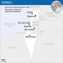
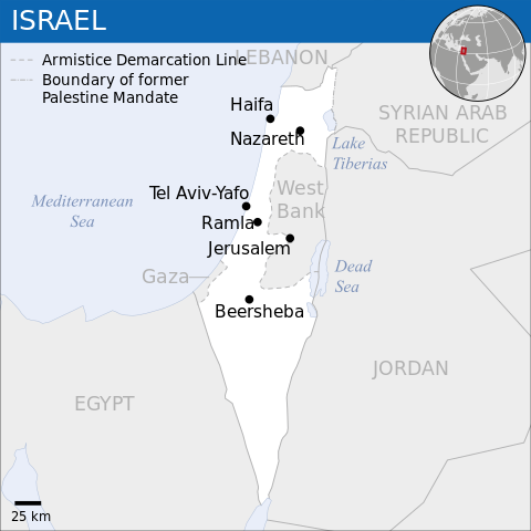
English: Locator map of Israel. العربية: خريطة إسرائيل. |
| نېټه | |
| سرچينه |
English: [1], OCHA, UNCS |
| ليکوال | |
| نورې بڼې |
|
| SVG genesis |
_-_ISR_-_UNOCHA-ar.svg)
_-_ISR_-_UNOCHA-ur.svg)
_-_ISR_-_UNOCHA-zh.svg)
_-_ISR_-_UNOCHA-id.svg)
_-_ISR_-_UNOCHA.svg)
منښتليک:
- تاسې کولی شئ چې:
- بيا يې د نورو سره شريک کړئ – همدا اثر ولمېسئ، و وېشئ او بيا يې خپور کړئ
- بيا ادلون بدلون راولئ – بدل شوی اثر خپل کړئ
- د لاندې شرطونو له مخې:
- اړوندېدنه – تاسې بايد دا اثر د ليکوال يا منښتگر لخوا د ځانگړو شويو اصولو سره اړونده وگڼئ (خو په دې توگه نه چې داسې ښکاره شي چې گنې تاسې يا ستاسې لخوا کارېدنه د اثر د ملاتړ سبب شوی)
 This map is part of a collection of 216 free country maps, created by the UN Office for the Coordination of Humanitarian Affairs (OCHA), to be used in print, web or broadcast products.
The ReliefWeb Location Maps released here are maps that highlight a country, its capital, major populated places and the surrounding regions. Attribution Requirements
Using the map without modifications: ensure that the sources and the disclaimer are below the map. Credit as follows: "Credit: OCHA". For use with alteration: remove the OCHA logo and disclaimer following any modification to the map, but keep the data sources as mentioned below the map. Credit the modified map as follows: "Based on OCHA map". You are responsible for the content of your map. We are keen to receive your feedback and hear how you used OCHA's maps. We would be grateful if you would notify us by e-mail and share your work with us. UN Disclaimer
The designations employed and the presentation of material of this map do not imply the expression of any opinion whatsoever on the part of the Secretariat of the United Nations concerning the legal status of any country, territory, city or area or of its authorities or concerning the delimitation of its frontiers or boundaries. |

|
Textual information (e.g. timestamp) once visible in the image itself has been moved into the image metadata and/or image description page. This makes the image easier to reuse and more language-neutral, and makes the text easier to process and search for. Commons discourages placing visible textual information in images. All licenses accepted on Commons permit this type of modification as a derivative work.
If attribution information were removed and the image is not public domain, replace this tag with {{Attribution metadata from licensed image}}.
|
د دوتنې پېښليک
په يوې نېټې/يوه وخت وټوکۍ چې د هماغه وخت او نېټې دوتنه چې څنگه ښکارېده هماغسې درښکاره شي.
| نېټه/وخت | بټنوک | ډډې | کارن | تبصره | |
|---|---|---|---|---|---|
| اوسنی | ۰۸:۲۶, ۸ اکتوبر ۲۰۲۳ | | ۲۵۰ × ۲۵۰ (۱۴۱ کيلوبايټ) | Trần Nguyễn Minh Huy | File uploaded using svgtranslate tool (https://svgtranslate.toolforge.org/). Added translation for vi. |
| ۰۶:۳۹, ۲۷ جولای ۲۰۲۲ |  | ۲۵۰ × ۲۵۰ (۱۴۰ کيلوبايټ) | Enkhsaihan2005 | File uploaded using svgtranslate tool (https://svgtranslate.toolforge.org/). Added translation for mn. | |
| ۰۶:۳۸, ۲۷ جولای ۲۰۲۲ |  | ۲۵۰ × ۲۵۰ (۱۳۹ کيلوبايټ) | Enkhsaihan2005 | File uploaded using svgtranslate tool (https://svgtranslate.toolforge.org/). Added translation for mn. | |
| ۰۱:۴۸, ۲۸ مارچ ۲۰۲۲ |  | ۲۵۰ × ۲۵۰ (۱۳۶ کيلوبايټ) | Nyilvoskt | File uploaded using svgtranslate tool (https://svgtranslate.toolforge.org/). Added translation for id. | |
| ۱۵:۲۱, ۱۷ فبروري ۲۰۲۲ |  | ۲۵۰ × ۲۵۰ (۱۳۴ کيلوبايټ) | Kurmanbek | File uploaded using svgtranslate tool (https://svgtranslate.toolforge.org/). Added translation for tr. | |
| ۲۲:۲۷, ۱۷ فبروري ۲۰۱۶ |  | ۲۵۰ × ۲۵۰ (۱۳۰ کيلوبايټ) | Wereldburger758 | Resized page to drawing. Removal watermark. Validation of image. | |
| ۰۳:۲۱, ۱۹ اگسټ ۲۰۱۴ |  | ۲۵۰ × ۲۵۰ (۱۸۵ کيلوبايټ) | Pharos | == {{int:filedesc}} == {{Information |description={{en|1=Locator map of Chile.}} |date=2013 |source={{en|1=[http://reliefweb.int/map/chile/chile-location-map-2013 Chile Locator Map (ReliefWeb)]}} |author={{en|1=[[w:en:United Nations Offi... |
د دوتنې کارېدنه
دا لاندينی مخ د همدې دوتنې سره تړنې لري:
د نړېوالې دوتنې کارېدنه
همدا دوتنه لاندينۍ نورې ويکي گانې کاروي:
- په ar.wikipedia.org کارونې
- په az.wikipedia.org کارونې
- په ban.wikipedia.org کارونې
- په bcl.wikipedia.org کارونې
- په bh.wikipedia.org کارونې
- په blk.wikipedia.org کارونې
- په bxr.wikipedia.org کارونې
- په dty.wikipedia.org کارونې
- په en.wikipedia.org کارونې
- په es.wikipedia.org کارونې
- په eu.wikipedia.org کارونې
- په fa.wikipedia.org کارونې
- په fr.wikipedia.org کارونې
- په gu.wikipedia.org کارونې
- په hy.wikipedia.org کارونې
- په id.wikipedia.org کارونې
- په incubator.wikimedia.org کارونې
- په ka.wikipedia.org کارونې
- په lo.wikipedia.org کارونې
- په ml.wikipedia.org کارونې
- په mn.wikipedia.org کارونې
- په mzn.wikipedia.org کارونې
- په ne.wikipedia.org کارونې
- په nso.wikipedia.org کارونې
- په pa.wikipedia.org کارونې
- په pnb.wikipedia.org کارونې
- په ro.wikipedia.org کارونې
- په ru.wikipedia.org کارونې
- په sco.wikipedia.org کارونې
- په sd.wikipedia.org کارونې
- په si.wikipedia.org کارونې
- په sl.wikipedia.org کارونې
- په sq.wikipedia.org کارونې
- په su.wikipedia.org کارونې
- په tcy.wikipedia.org کارونې
- په te.wikipedia.org کارونې
- په th.wikipedia.org کارونې
- په to.wikipedia.org کارونې
- په tr.wikipedia.org کارونې
د دې دوتنې نورې نړېوالې کارېدنې کتل.
_-_ISR_-_UNOCHA.svg)
_-_ISR_-_UNOCHA.svg)