
دوتنه:Czechoslovakia IV.png
د همدې ليدنې کچه: ۸۰۰ × ۳۶۴ پېکسل. نورې ژورليدنې: ۳۲۰ × ۱۴۶ پېکسل | ۶۴۰ × ۲۹۱ پېکسل | ۱٬۱۲۸ × ۵۱۳ پېکسل.
اصلي دوتنه (۱٬۱۲۸ × ۵۱۳ پېکسل, د دوتنې کچه: ۱۳۰ کيلوبايټ, MIME بڼه: image/png)
| څرگندونه |
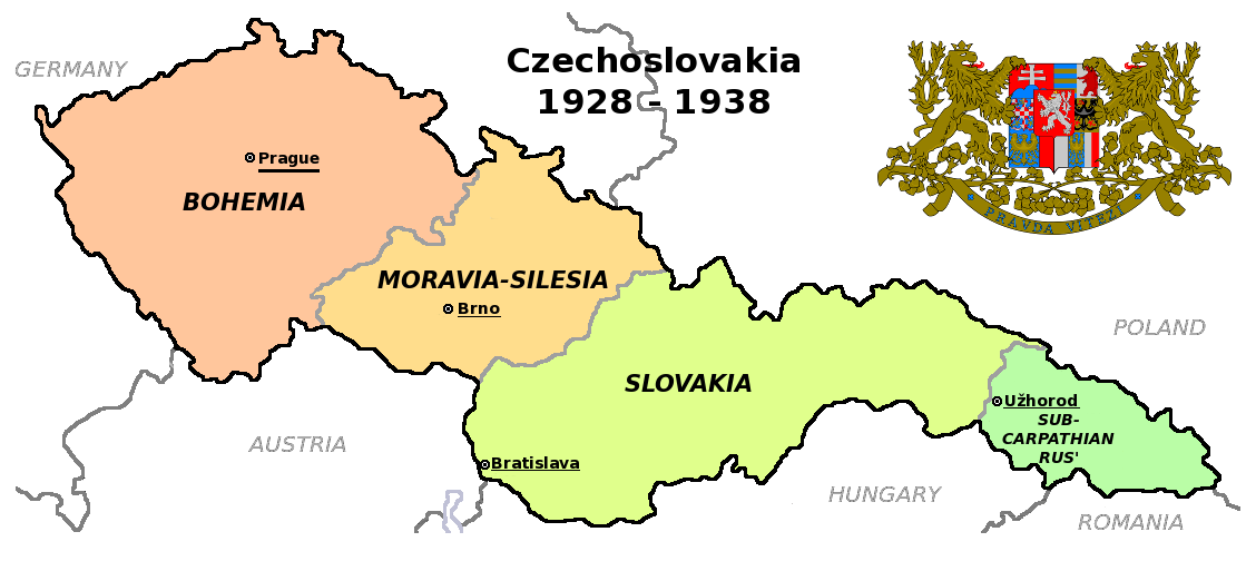
Čeština: Zemská mapa Československa v letech 1928 až 1938 s vyznačenými zemskými hlavními městy English: Maps of Czechoslovakia in 1928-1938 with marked borders of all four Czechoslovak lands and their regional capital cities |
| نېټه | (UTC) |
| سرچينه | |
| ليکوال |
|
| نورې بڼې |
Derivative works of this file: |
| This is a retouched picture, which means that it has been digitally altered from its original version. Modifications: Simplified map. The original can be viewed here: Czechoslovakia COA large.svg:
|
دا دوتنه د کريټيف کامنز Attribution-Share Alike 3.0 Unported په منښتليک سمبال ده.
- تاسې کولی شئ چې:
- بيا يې د نورو سره شريک کړئ – همدا اثر ولمېسئ، و وېشئ او بيا يې خپور کړئ
- بيا ادلون بدلون راولئ – بدل شوی اثر خپل کړئ
- د لاندې شرطونو له مخې:
- اړوندېدنه – تاسې بايد دا اثر د ليکوال يا منښتگر لخوا د ځانگړو شويو اصولو سره اړونده وگڼئ (خو په دې توگه نه چې داسې ښکاره شي چې گنې تاسې يا ستاسې لخوا کارېدنه د اثر د ملاتړ سبب شوی)
- يوشان شريکول – که تاسې همدا اثر بدلوئ، رغوئ، او يا يې هم سر له نوي جوړوئ نو په پايله کې رامېنځ ته شوی اثر به يوازې د همدې دوتنې ورته منښتليک پر بنسټ خپروئ.
Original upload log
This image is a derivative work of the following images:
- File:Czechoslovakia01.png licensed with PD-self
- 2011-05-19T10:54:48Z PANONIAN 1128x513 (64020 Bytes) minor change, marked provincial capitals
- 2011-05-17T09:53:27Z PANONIAN 1128x513 (63994 Bytes) Reverted to version as of 10:38, 24 April 2011 - because this is map of Czechoslovakia and it was capital of Czechoslovakia
- 2011-05-17T05:07:38Z Millenium187 1128x513 (56086 Bytes) Why was Prague underlined and Vienna, Brno, Bratislava and other capital cities were not? -- corrected
- 2011-04-24T10:38:30Z PANONIAN 1128x513 (63994 Bytes) few corrections
- 2011-04-23T11:31:49Z PANONIAN 1128x509 (62348 Bytes) improved version
- 2008-12-20T20:58:14Z Kirk 1100x497 (80038 Bytes) {{Information |Description= |Source= |Date= |Author= |Permission= |other_versions= }}
- 2006-12-28T16:11:35Z Electionworld 1100x497 (92110 Bytes) {{ew|en|PANONIAN}} Map of {{link|Czechoslovakia}} (self made) Note: The provinces shown on the map were introduced by Act No. 125/1927 Zb. and became effective in 1928. {{PD-self}} [[Category:Maps of Czechoslovakia]] [[Cat
- File:Czechoslovakia_COA_large.svg licensed with Cc-by-sa-3.0-migrated, GFDL
- 2010-09-06T23:55:59Z Fry1989 635x350 (1316079 Bytes) Reverted to version as of 23:52, 6 September 2010 this version will have to stay, message me with any corrections you want and I'll see what I can do
- 2010-09-06T23:53:49Z Kwasura 635x350 (1440388 Bytes) correction
- 2010-09-06T23:52:33Z Fry1989 635x350 (1316079 Bytes) lets see if it'll upload for me, checks out fine in inkscape
- 2010-09-06T23:50:19Z Kwasura 635x350 (1440373 Bytes) correction
- 2010-08-12T19:52:16Z Delta 51 635x350 (1440480 Bytes) Reverted to version as of 08:13, 5 November 2006 (the new versions don't work at all)
- 2010-08-09T20:16:25Z Kwasura 635x350 (1026422 Bytes) trying
- 2010-08-09T20:06:57Z Kwasura 635x350 (1976 Bytes) well, I just don't know how to do it...
- 2010-08-09T20:05:24Z Kwasura 635x350 (1976 Bytes) one more try
- 2010-08-09T20:02:09Z Kwasura 635x350 (1976 Bytes) correction 2nd try
- 2010-08-09T19:57:24Z Kwasura 635x350 (1976 Bytes) correction
- 2006-11-05T08:13:30Z Happenstance 635x350 (1440480 Bytes) crowns for the eagles
- 2006-06-17T05:00:05Z Happenstance 635x350 (1439900 Bytes) ==Author:== * commons: [[user:Shazz|Shazz]] * pl.wiki: [[w:pl:user:Shazz|Shazz]] ==Description== * '''cs:''' Znak Československa - velký * '''pl:''' Godło Czechosłowacji - duże * '''en:''' Coat of Arms of Czechoslovakia
Uploaded with derivativeFX
د دوتنې پېښليک
په يوې نېټې/يوه وخت وټوکۍ چې د هماغه وخت او نېټې دوتنه چې څنگه ښکارېده هماغسې درښکاره شي.
| نېټه/وخت | بټنوک | ډډې | کارن | تبصره | |
|---|---|---|---|---|---|
| اوسنی | ۱۸:۳۶, ۱۲ اگسټ ۲۰۱۱ | | ۱٬۱۲۸ × ۵۱۳ (۱۳۰ کيلوبايټ) | Millenium187 | {{Information |Description={{cs|Zemská mapa Československa v letech 1928 až 1938}} {{en|Maps of Czechoslovakia in 1928-1938 with marked borders of all four Czechoslovak countries}} |Source=*File:Czechoslovakia01.png *[[:File:Czechoslovakia_COA_l |
د دوتنې کارېدنه
دا لاندينی مخ د همدې دوتنې سره تړنې لري:
د نړېوالې دوتنې کارېدنه
همدا دوتنه لاندينۍ نورې ويکي گانې کاروي:
- په ca.wikipedia.org کارونې
- په en.wikipedia.org کارونې
- په fa.wikipedia.org کارونې
- په fr.wikipedia.org کارونې