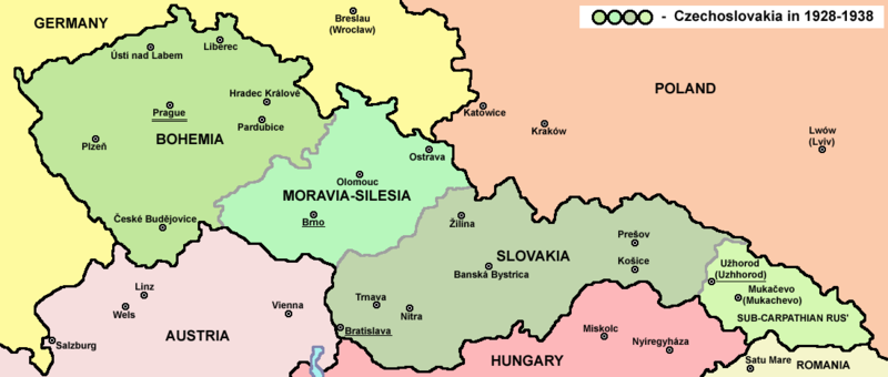
دوتنه:Czechoslovakia01.png

د همدې ليدنې کچه: ۸۰۰ × ۳۴۰ پېکسل. نورې ژورليدنې: ۳۲۰ × ۱۳۶ پېکسل | ۱٬۱۰۰ × ۴۶۸ پېکسل.
اصلي دوتنه (۱٬۱۰۰ × ۴۶۸ پېکسل, د دوتنې کچه: ۶۳ کيلوبايټ, MIME بڼه: image/png)
د دوتنې پېښليک
په يوې نېټې/يوه وخت وټوکۍ چې د هماغه وخت او نېټې دوتنه چې څنگه ښکارېده هماغسې درښکاره شي.
| نېټه/وخت | بټنوک | ډډې | کارن | تبصره | |
|---|---|---|---|---|---|
| اوسنی | ۱۴:۴۸, ۱۲ جولای ۲۰۲۲ |  | ۱٬۱۰۰ × ۴۶۸ (۶۳ کيلوبايټ) | Sebastian Wallroth | cropped |
| ۱۰:۵۴, ۱۹ مې ۲۰۱۱ |  | ۱٬۱۲۸ × ۵۱۳ (۶۳ کيلوبايټ) | PANONIAN | minor change, marked provincial capitals | |
| ۰۹:۵۳, ۱۷ مې ۲۰۱۱ |  | ۱٬۱۲۸ × ۵۱۳ (۶۲ کيلوبايټ) | PANONIAN | Reverted to version as of 10:38, 24 April 2011 - because this is map of Czechoslovakia and it was capital of Czechoslovakia | |
| ۰۵:۰۷, ۱۷ مې ۲۰۱۱ |  | ۱٬۱۲۸ × ۵۱۳ (۵۵ کيلوبايټ) | Millenium187 | Why was Prague underlined and Vienna, Brno, Bratislava and other capital cities were not? -- corrected | |
| ۱۰:۳۸, ۲۴ اپرېل ۲۰۱۱ |  | ۱٬۱۲۸ × ۵۱۳ (۶۲ کيلوبايټ) | PANONIAN | few corrections | |
| ۱۱:۳۱, ۲۳ اپرېل ۲۰۱۱ |  | ۱٬۱۲۸ × ۵۰۹ (۶۱ کيلوبايټ) | PANONIAN | improved version | |
| ۲۰:۵۸, ۲۰ ډيسمبر ۲۰۰۸ |  | ۱٬۱۰۰ × ۴۹۷ (۷۸ کيلوبايټ) | Kirk979 | {{Information |Description= |Source= |Date= |Author= |Permission= |other_versions= }} | |
| ۱۶:۱۱, ۲۸ ډيسمبر ۲۰۰۶ |  | ۱٬۱۰۰ × ۴۹۷ (۹۰ کيلوبايټ) | Electionworld | {{ew|en|PANONIAN}} Map of {{link|Czechoslovakia}} (self made) Note: The provinces shown on the map were introduced by Act No. 125/1927 Zb. and became effective in 1928. {{PD-self}} Category:Maps of Czechoslovakia Category:Maps of Czech history |
د دوتنې کارېدنه
داسې هېڅ کوم مخ نه شته چې د دغې دوتنې سره تړنې ولري.
د نړېوالې دوتنې کارېدنه
همدا دوتنه لاندينۍ نورې ويکي گانې کاروي:
- په af.wikipedia.org کارونې
- په als.wikipedia.org کارونې
- په ang.wikipedia.org کارونې
- په an.wikipedia.org کارونې
- په ar.wikipedia.org کارونې
- په arz.wikipedia.org کارونې
- په azb.wikipedia.org کارونې
- په az.wikipedia.org کارونې
- په ba.wikipedia.org کارونې
- په bcl.wikipedia.org کارونې
- په be-tarask.wikipedia.org کارونې
- په be.wikipedia.org کارونې
- په bg.wikipedia.org کارونې
- په bn.wikipedia.org کارونې
- په br.wikipedia.org کارونې
- په ca.wikipedia.org کارونې
- په cs.wikipedia.org کارونې
- په cv.wikipedia.org کارونې
- په cy.wikipedia.org کارونې
- په de.wikipedia.org کارونې
- په diq.wikipedia.org کارونې
- په dsb.wikipedia.org کارونې
- په el.wikipedia.org کارونې
- په en.wikipedia.org کارونې
د دې دوتنې نورې نړېوالې کارېدنې کتل.


